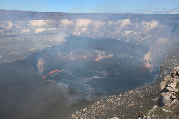
Map showing the June 27th flow in Kīlauea's East Rift Zone as of September 3, 2014. The area of the flow as mapped on September 1 is shown in pink, while widening and advancement of the flow as of September 3 is shown in red. Last night, lava welled up out of the crack it was filling and spilled out onto the ground to feed new surface flows.
Images
Hawaiian Volcano Observatory images of eruptive activity, field work, and more.
Map showing the June 27th flow in Kīlauea's East Rift Zone as of September 3, 2014. The area of the flow as mapped on September 1 is shown in pink, while widening and advancement of the flow as of September 3 is shown in red. Last night, lava welled up out of the crack it was filling and spilled out onto the ground to feed new surface flows.
Lava breakout flowing into deep ground crack along Kīlauea, Pu‘u ‘Ō‘ō
Lava breakout flowing into deep ground crack along Kīlauea, Pu‘u ‘Ō‘ōLava from June 27 breakout flowing into deep ground crack along Kīlauea East Rift Zone, Pu‘u ‘Ō‘ō, Hawai‘i
Lava breakout flowing into deep ground crack along Kīlauea, Pu‘u ‘Ō‘ō
Lava breakout flowing into deep ground crack along Kīlauea, Pu‘u ‘Ō‘ōLava from June 27 breakout flowing into deep ground crack along Kīlauea East Rift Zone, Pu‘u ‘Ō‘ō, Hawai‘i
Map showing the June 27th flow in Kīlauea's East Rift Zone as of September 1, 2014. The area of the flow as mapped on August 29 is shown in pink, while widening and advancement of the flow as of September 1 is shown in red.
Map showing the June 27th flow in Kīlauea's East Rift Zone as of August 29, 2014. The area of the flow as mapped on August 28 is shown in pink, while widening and advancement of the flow as of August 29 is shown in red. All older lava flows (1983-2014) are shown in gray. The thin yellow line marks a portion of the lava tube feeding the flow.
Steam rising from Kīlauea's ERZ ground crack - lava flowing within ...
Steam rising from Kīlauea's ERZ ground crack - lava flowing within ...Steam rising from Kīlauea's East Rift Zone ground crack - lava flowing within crack from June 27 breakout. Pu‘u ‘Ō‘ō cone center horizon Kīlauea volcano, Hawai‘i.
leading edge of the June 27th lava flow, looking east down Kīlauea'...
leading edge of the June 27th lava flow, looking east down Kīlauea'...A wide view of the leading edge of the June 27th lava flow, looking east down Kīlauea's East Rift Zone. The main body of the June 27th flow ends near the center of the photograph, where lava poured into a deep ground crack.
Map showing the June 27th flow in Kīlauea's East Rift Zone as of August 28, 2014. The area of the flow as mapped on August 27 is shown in pink, while widening and advancement of the flow as of August 28 is shown in red. All older lava flows (1983-2014) are shown in gray. The thin yellow line marks a portion of the lava tube feeding the flow.
Map showing the June 27th flow in Kīlauea's East Rift Zone as of August 25, 2014. The area of the flow as mapped on August 22 is shown in pink, while widening and advancement of the flow as of August 25 is shown in red. The brown line marks the ground crack that channeled lava to the east, where it emerged to form a new pad of lava over the past couple of days.
Map showing the June 27th flow in Kīlauea's East Rift Zone as of August 22, 2014. The area of the flow as mapped on August 12 is shown in pink, while widening and advancement of the flow as of August 22 is shown in red. The heavy brown line marks the extent of steaming along a ground crack into which lava is flowing.
Map showing the June 27th flow at Pu‘u ‘Ō‘ō in Kīlauea's East Rift Zone in relation to the eastern part of the Island of Hawai‘i as of August 12, 2014. The area of the flow as mapped on August 6 is shown in pink, while widening and advancement of the flow as of August 12 is shown in red.
Map showing the June 27th flow at Pu‘u ‘Ō‘ō in Kīlauea's East Rift Zone in relation to the eastern part of the Island of Hawai‘i as of August 6, 2014. The area of the flow as mapped on July 29 is shown in pink, while widening and advancement of the flow as of August 6 is shown in red.
Map showing the June 27th flow at Pu‘u ‘Ō‘ō in Kīlauea's East Rift Zone. The area of the flow as mapped on July 18 is shown in pink, while widening of the flow as of July 29 is shown in red.
Map showing the June 27, 2014, breakout and the Kahauale‘a 2 flow in relation to the eastern part of the Island of Hawai‘i as of June 30, 2014. The Kahauale‘a 2 flow (pale orange) is no longer active — it was beheaded when the lava level at Pu‘u ‘Ō‘ō dropped with the onset of the June 27 breakout.
Map showing the June 27, 2014, breakout at Pu‘u ‘Ō‘ō in Kīlauea's East Rift Zone. The area of the new flow as mapped on June 27 is shown in pink, while widening of the flow as June 30 is shown in red.
Lava flow breakout from NE flank of Pu‘u ‘Ō‘ō on the ERZ of Kīlauea
Lava flow breakout from NE flank of Pu‘u ‘Ō‘ō on the ERZ of KīlaueaLava flow breakout from northeast flank of Pu‘u ‘Ō‘ō on the East Rift Zone of Kīlauea volcano.
Lava flow breakout from NE flank of Pu‘u ‘Ō‘ō on the ERZ of Kīlauea
Lava flow breakout from NE flank of Pu‘u ‘Ō‘ō on the ERZ of KīlaueaLava flow breakout from northeast flank of Pu‘u ‘Ō‘ō on the East Rift Zone of Kīlauea volcano.
Map showing the Kahauale‘a 2 flow (pink) in relation to the eastern part of the Island of Hawai‘i as of June 17, 2014. The most distant active Kahauale‘a 2 lava flows were 7.1 km (4.4 miles) straight-line distance northeast of Pu‘u ‘Ō‘ō.
As noted above, the new flows have caused withdrawal of magma within Pu‘u ‘Ō‘ō and small collapses of the several cones on the crater floor.
The withdrawal of magma from within Pu‘u ‘Ō‘ō, to feed the new flows, has caused minor subsidence of the Pu‘u ‘Ō‘ō crater floor since this morning. This was associated with small collapses at the spatter cones on the crater floor.
Hilo was again threatened by a Mauna Loa lava flow in 1882
Hilo was again threatened by a Mauna Loa lava flow in 1882A sketch by Joseph Nāwahī showing the 1881 lava flow approaching Hilo. (Courtesy of National Park Service, Hawai‘i Volcanoes National Park, HAVO 394, Volcano House Guest Register 1873 to 1885, illustration by Joseph Nāwahī, February 21, 1881.)
Monitoring Volcanic Gases on Kilauea's East Rift Zone
Monitoring Volcanic Gases on Kilauea's East Rift ZoneHawaiian Volcano Observatory Geochemist Jeff Sutton and CSAV international volcanology students visit a continuous gas monitoring site on Kilauea's east rift zone during field studies portion of the summer training course.
Monitoring Volcanic Gases on Kilauea's East Rift Zone II
Monitoring Volcanic Gases on Kilauea's East Rift Zone IIHawaiian Volcano Observatory Geochemist Jeff Sutton and CSAV international volcanology students visit a continuous gas monitoring site on Kilauea's east rift zone during field studies portion of the summer training course.