Kīlauea: a youngster among world's active volcanoes
Kīlauea: a youngster among world's active volcanoesKīlauea: a youngster among world's active volcanoes


Official websites use .gov
A .gov website belongs to an official government organization in the United States.

Secure .gov websites use HTTPS
A lock () or https:// means you’ve safely connected to the .gov website. Share sensitive information only on official, secure websites.

Hawaiian Volcano Observatory images of eruptive activity, field work, and more.

Kīlauea: a youngster among world's active volcanoes
Kīlauea: a youngster among world's active volcanoes

This video shows a rockfall and subsequent explosion that occurred at 7:03 a.m. HST today within the "Overlook crater" at the summit of Kīlauea. This collapse was followed by a smaller rockfall at 7:07 a.m. (not shown in video).
This video shows a rockfall and subsequent explosion that occurred at 7:03 a.m. HST today within the "Overlook crater" at the summit of Kīlauea. This collapse was followed by a smaller rockfall at 7:07 a.m. (not shown in video).

On January 8, 2018, Kīlauea Volcano's summit lava lake level was 38 m (125 ft) below the rim of "Overlook crater," the small crater that formed above the active vent in Halema‘uma‘u.
On January 8, 2018, Kīlauea Volcano's summit lava lake level was 38 m (125 ft) below the rim of "Overlook crater," the small crater that formed above the active vent in Halema‘uma‘u.

First high-definition thermal image of the Halema‘uma‘u lava lake in the New Year, taken shortly after midnight on January 1, 2018. This camera was deployed to track the dynamic surface activity of the lava lake at the summit of Kīlauea.
First high-definition thermal image of the Halema‘uma‘u lava lake in the New Year, taken shortly after midnight on January 1, 2018. This camera was deployed to track the dynamic surface activity of the lava lake at the summit of Kīlauea.

Example Hydrotherm output. Hydrotherm is a three-dimensional simulation of multiphase groundwater flow and heat transport in the temperature range of 0 to 1200 degrees Celsius and the pressure range of 1 to 1000 MPa.
Example Hydrotherm output. Hydrotherm is a three-dimensional simulation of multiphase groundwater flow and heat transport in the temperature range of 0 to 1200 degrees Celsius and the pressure range of 1 to 1000 MPa.
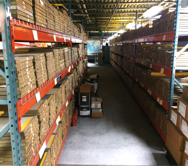
Boxes of historical seismograms (thousands of them!) in the basement of the USGS Hawaiian Volcano Observatory in the summer of 2017. These records span over a century of earthquake monitoring in Hawaii. Dr. Thomas Jaggar installed the first seismometer in 1912, and paper records were used for recording into the 1990s.
Boxes of historical seismograms (thousands of them!) in the basement of the USGS Hawaiian Volcano Observatory in the summer of 2017. These records span over a century of earthquake monitoring in Hawaii. Dr. Thomas Jaggar installed the first seismometer in 1912, and paper records were used for recording into the 1990s.

A bursting bubble on the surface of a lava lake produces an impulsive signal on an infrasound recording. This photo shows a group of bubbles about 5 m (16 ft) across bursting on the Halema‘uma‘u lava lake at the summit of Kīlauea Volcano. The blue line is an infrasound recording of 50 seconds of similar activity.
A bursting bubble on the surface of a lava lake produces an impulsive signal on an infrasound recording. This photo shows a group of bubbles about 5 m (16 ft) across bursting on the Halema‘uma‘u lava lake at the summit of Kīlauea Volcano. The blue line is an infrasound recording of 50 seconds of similar activity.

Aerial view of a bomb detonating on Mauna Loa near the 8500-foot elevation source of the 1935 lava flow on the morning of December 27, 1935. This was one of twenty 600-pound bombs dropped on the lava flow that morning by the Army Bombing Squadron from Luke Field, O‘ahu. Photo by Army Air Corps, 11th Photo Section.
Aerial view of a bomb detonating on Mauna Loa near the 8500-foot elevation source of the 1935 lava flow on the morning of December 27, 1935. This was one of twenty 600-pound bombs dropped on the lava flow that morning by the Army Bombing Squadron from Luke Field, O‘ahu. Photo by Army Air Corps, 11th Photo Section.

Kīlauea Volcano's Kamokuna lava delta on October 6, 2017. Multiple streams of lava entering the ocean on both sides of the delta created small plumes of laze (lava haze). The visible part of the delta, which is deceptively stable, was built by many small lava flows accumulating on an unstable foundation of unconsolidated volcanic rock fragments. USGS photo by L.
Kīlauea Volcano's Kamokuna lava delta on October 6, 2017. Multiple streams of lava entering the ocean on both sides of the delta created small plumes of laze (lava haze). The visible part of the delta, which is deceptively stable, was built by many small lava flows accumulating on an unstable foundation of unconsolidated volcanic rock fragments. USGS photo by L.

Kīlauea Volcano's summit lava lake activity over the past few days has been typical, with intermittent sites of spattering and migration of the crust from north to south (top to bottom of image). This view of the lava lake was captured on the evening of Saturday, November 18.
Kīlauea Volcano's summit lava lake activity over the past few days has been typical, with intermittent sites of spattering and migration of the crust from north to south (top to bottom of image). This view of the lava lake was captured on the evening of Saturday, November 18.

View of Moku‘āweoweo's North Pit, looking to the west-southwest. The summit of Mauna Loa is the peak visible in the background, slightly left of center. The two linear features in the foreground are ramparts from previous fissure eruptions.
View of Moku‘āweoweo's North Pit, looking to the west-southwest. The summit of Mauna Loa is the peak visible in the background, slightly left of center. The two linear features in the foreground are ramparts from previous fissure eruptions.

Close up of Sheet 2 of "Lava inundation zone maps for Mauna Loa, Island of Hawai‘i," recently published by the U.S. Geological Survey. Colors depict lava Inundation zones for the Kaumana, Waiākea, and Volcano-Mountain View regions on Mauna Loa. Yellow indicates the volcano's Northeast Rift Zone, one area along which lava could erupt.
Close up of Sheet 2 of "Lava inundation zone maps for Mauna Loa, Island of Hawai‘i," recently published by the U.S. Geological Survey. Colors depict lava Inundation zones for the Kaumana, Waiākea, and Volcano-Mountain View regions on Mauna Loa. Yellow indicates the volcano's Northeast Rift Zone, one area along which lava could erupt.

The lava lake within Halema‘uma‘u, a crater at the summit of Kīlauea, was about 30 m (98 ft) below the vent rim on the day of this photo (January 7, 2016).
The lava lake within Halema‘uma‘u, a crater at the summit of Kīlauea, was about 30 m (98 ft) below the vent rim on the day of this photo (January 7, 2016).
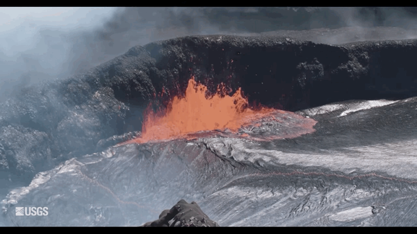
Animated GIF of lava bubbling up from Kīlauea Volcano in Hawaiʻi Volcanoes National Park. The source of the GIF comes from footage found within the USGS video: Kīlauea Summit Eruption | Lava Returns to Halemaʻumaʻu.
Animated GIF of lava bubbling up from Kīlauea Volcano in Hawaiʻi Volcanoes National Park. The source of the GIF comes from footage found within the USGS video: Kīlauea Summit Eruption | Lava Returns to Halemaʻumaʻu.

This view of Halema‘uma‘u as it appeared in the 1917 relief model by George Carroll Curtis shows fine details around the crater, including the first road for automobiles, which ended near the crater rim. The light-colored circular feature around Halema‘uma‘u is a nearly continuous escarpment along which subsidence occurred. Photo by Burr A. Church.
This view of Halema‘uma‘u as it appeared in the 1917 relief model by George Carroll Curtis shows fine details around the crater, including the first road for automobiles, which ended near the crater rim. The light-colored circular feature around Halema‘uma‘u is a nearly continuous escarpment along which subsidence occurred. Photo by Burr A. Church.

The 1917 Curtis relief model of Kīlauea Volcano's summit shows many well-known geologic features, including the summit caldera (large depression), Halema‘uma‘u (crater within the caldera), Kīlauea Iki (crater at far right), and elaborate drainage patterns (foreground). Photo by Burr A. Church.
The 1917 Curtis relief model of Kīlauea Volcano's summit shows many well-known geologic features, including the summit caldera (large depression), Halema‘uma‘u (crater within the caldera), Kīlauea Iki (crater at far right), and elaborate drainage patterns (foreground). Photo by Burr A. Church.

Aerial view of Mauna Loa erupting on the morning of March 25, 1984, the first day of the volcano's most recent eruption. The lava flow was advancing southeast, toward Kīlauea, from fissure vents at an elevation of about 11,200 feet on Mauna Loa's Northeast Rift Zone. Moku‘āweoweo, Mauna Loa's summit caldera, is visible at top left.
Aerial view of Mauna Loa erupting on the morning of March 25, 1984, the first day of the volcano's most recent eruption. The lava flow was advancing southeast, toward Kīlauea, from fissure vents at an elevation of about 11,200 feet on Mauna Loa's Northeast Rift Zone. Moku‘āweoweo, Mauna Loa's summit caldera, is visible at top left.

A USGS Hawaiian Volcano Observatory geologist monitored the advance of an ‘A‘ā lava flow on April 6 during the 1984 Mauna Loa eruption. This flow was about 4 m (13 ft) high and advancing at a rate of 50 m (55 yards) per hour. Lava reached within 6 km (4 mi) of Hilo city limits before the 22-day-long eruption ended on April 15.
A USGS Hawaiian Volcano Observatory geologist monitored the advance of an ‘A‘ā lava flow on April 6 during the 1984 Mauna Loa eruption. This flow was about 4 m (13 ft) high and advancing at a rate of 50 m (55 yards) per hour. Lava reached within 6 km (4 mi) of Hilo city limits before the 22-day-long eruption ended on April 15.

Spattering is common in Kīlauea Volcano's summit lava lake, and consists of many large bursting gas bubbles. The fluid nature of the lake can be seen when lava hits the wall and flows downward like syrup. The thin, flexible nature of the crust is also shown here, as the bursting gas bubbles rip and fold the thin skin on the lake.
Spattering is common in Kīlauea Volcano's summit lava lake, and consists of many large bursting gas bubbles. The fluid nature of the lake can be seen when lava hits the wall and flows downward like syrup. The thin, flexible nature of the crust is also shown here, as the bursting gas bubbles rip and fold the thin skin on the lake.

USGS Hawaiian Volcano Observatory field engineers begin the process of lowering a tiltmeter into a deep borehole on the west flank of Mauna Loa. The installation is guided by a custom-built apparatus that includes a 3-D printed jig. This tiltmeter will help monitor the currently elevated activity of Mauna Loa Volcano. USGS photo.
USGS Hawaiian Volcano Observatory field engineers begin the process of lowering a tiltmeter into a deep borehole on the west flank of Mauna Loa. The installation is guided by a custom-built apparatus that includes a 3-D printed jig. This tiltmeter will help monitor the currently elevated activity of Mauna Loa Volcano. USGS photo.

This perched lava channel, which was as much as 150 feet (45 meters) above the ground, carried lava downslope from the Pu‘u ‘Ō‘ō Fissure D vent during episode 58 of Kīlauea Volcano's ongoing East Rift Zone eruption. The channel was the main path for lava between July and November 2007. Episode 58 continued until early March 2011.
This perched lava channel, which was as much as 150 feet (45 meters) above the ground, carried lava downslope from the Pu‘u ‘Ō‘ō Fissure D vent during episode 58 of Kīlauea Volcano's ongoing East Rift Zone eruption. The channel was the main path for lava between July and November 2007. Episode 58 continued until early March 2011.