
Lua Hou, a pit crater located at the southern extent of Moku‘āweoweo, near where it meets the Southwest Rift Zone. USGS image by K. Mulliken.
Images
Hawaiian Volcano Observatory images of eruptive activity, field work, and more.
Filter Total Items: 4072

October 28, 2022 — Mauna Loa Overflight, Lua Hou
Lua Hou, a pit crater located at the southern extent of Moku‘āweoweo, near where it meets the Southwest Rift Zone. USGS image by K. Mulliken.

October 28, 2022—Kīlauea summit thermal map
A helicopter overflight on October 28, 2022, allowed for aerial visual and thermal imagery to be collected of Halema‘uma‘u crater at the summit of Kīlauea. The active lake surface is limited to the western portion of the crater.
A helicopter overflight on October 28, 2022, allowed for aerial visual and thermal imagery to be collected of Halema‘uma‘u crater at the summit of Kīlauea. The active lake surface is limited to the western portion of the crater.

October 28, 2022 — Mauna Loa Overflight, 1950 Fissures
October 28, 2022 — Mauna Loa Overflight, 1950 FissuresGas issues from a crack marking the location of fissures that erupted from Mauna Loa’s Southwest Rift Zone in 1950. The presence of gas is normal at this location, near Sulphur Cone. USGS image by K. Mulliken.

October 28, 2022 — Mauna Loa Overflight, Lua Poholo
October 28, 2022 — Mauna Loa Overflight, Lua PoholoLua Poholo, a pit crater located on the northern side of Moku‘āweoweo, Mauna Loa’s summit caldera, near where the Northeast Rift Zone meets the summit caldera. Part of the pre-collapse floor of the pit crater remained intact as the pit crater formed, and is visible as the slanted slab at the base.

Plot showing the magnitude and time of earthquakes in the October 2022 Pāhala sequence
Plot showing the magnitude and time of earthquakes in the October 2022 Pāhala sequencePlot showing the magnitude and time of earthquakes in the October 2022 Pāhala sequence. The magnitude 5.0 mainshock is shown in blue and the aftershocks with 6.2 miles (10 km) of that event are shown in yellow to red with the color based on their time of occurrence. USGS plot.

Halema‘uma‘u crater and lava lake—12 October 2022
Panoramic view of Halema‘uma‘u crater, looking east, at Kīlauea summit. Lava continues to erupt from the west vent complex into the active lava lake. USGS photo taken by F. Trusdell on the morning of October 12, 2022.
Panoramic view of Halema‘uma‘u crater, looking east, at Kīlauea summit. Lava continues to erupt from the west vent complex into the active lava lake. USGS photo taken by F. Trusdell on the morning of October 12, 2022.

Halema‘uma‘u lava lake—12 October 2022
Image of the Kīlauea summit eruption within Halema‘uma‘u crater. The western vent complex (fuming cones in foreground), Halema‘uma‘u lava lake and south pond (silvery surface in center), and large island (darker lava in upper left) and all visible in this view from the west rim. Incandescent lava spatter is visible at the east end of the active lava lake.
Image of the Kīlauea summit eruption within Halema‘uma‘u crater. The western vent complex (fuming cones in foreground), Halema‘uma‘u lava lake and south pond (silvery surface in center), and large island (darker lava in upper left) and all visible in this view from the west rim. Incandescent lava spatter is visible at the east end of the active lava lake.

October 7, 2022—Kīlauea summit eruption reference map
October 7, 2022—Kīlauea summit eruption reference mapThis reference map depicts the ongoing Kīlauea summit eruption on October 7, 2022. One eruptive vent (orange) is active within Halema‘uma‘u, on the western side of the crater floor. An adjacent pond (purple) is feeding lava to a larger lake (red) via a crusted-over tube.

Hawaiian Volcano Observatory Mauna Loa monitoring data August-October 2022
Hawaiian Volcano Observatory Mauna Loa monitoring data August-October 2022Hawaiian Volcano Observatory Mauna Loa monitoring data showing increased ground deformation rates (top) and earthquake rates (bottom) from August 8 through October 5, 2022.

October 5, 2022 - Active lava lake and western vent complex within Halema‘uma‘u
October 5, 2022 - Active lava lake and western vent complex within Halema‘uma‘uThe eruption continues within Halema‘uma‘u at the summit of Kīlauea. This telephoto, looking east from the rim of Halema‘uma‘u, shows the active lava lake (center), with active lava ponds to the southeast (upper right) and west (lower center). The silvery surface of these three features is the active lava.

October 5, 2022 - Active lava lake and crater floor within Halema‘uma‘u, Kīlauea
October 5, 2022 - Active lava lake and crater floor within Halema‘uma‘u, KīlaueaView of over half of the crater floor and active lava lake (center right) within Halema‘uma‘u at the summit of Kīlauea on October 5, 2022. In this view looking east, all but the southwest portion of Halema‘uma‘u's crater floor is visible. USGS photo by N. Deligne.

UAS mission at Kīlauea summit - October 5, 2022
This photo shows a Unoccupied Aircraft System (UAS) unit staged for take-off on October 5, 2022. Data from this flight will be used to construct an updated high resolution map of Halema‘uma‘u at the summit of Kīlauea.
This photo shows a Unoccupied Aircraft System (UAS) unit staged for take-off on October 5, 2022. Data from this flight will be used to construct an updated high resolution map of Halema‘uma‘u at the summit of Kīlauea.

October 5, 2022—Kīlauea summit UAS thermal maps
Uncrewed aircraft systems (UAS) flights on October 5, 2022, allowed for aerial visual and thermal imagery to be collected of Halema‘uma‘u crater at the summit of Kīlauea. The active lake surface is limited to the western portion of the crater.
Uncrewed aircraft systems (UAS) flights on October 5, 2022, allowed for aerial visual and thermal imagery to be collected of Halema‘uma‘u crater at the summit of Kīlauea. The active lake surface is limited to the western portion of the crater.

“Noisy” InSAR interferogram examples covering the Island of Hawaiʻi
“Noisy” InSAR interferogram examples covering the Island of Hawaiʻi“Noisy” InSAR interferogram examples covering the Island of Hawaiʻi. (A) shows data that spans 12 days. This InSAR image show similar concentric ring patterns over both Mauna Loa and Mauna Kea.

2022 Kīlauea GPS Campaign
In September 2022, HVO scientists set up GPS equipment at various benchmarks on Kīlauea volcano as part of routine annual deformation monitoring. USGS photo by A.P. Ellis.
In September 2022, HVO scientists set up GPS equipment at various benchmarks on Kīlauea volcano as part of routine annual deformation monitoring. USGS photo by A.P. Ellis.
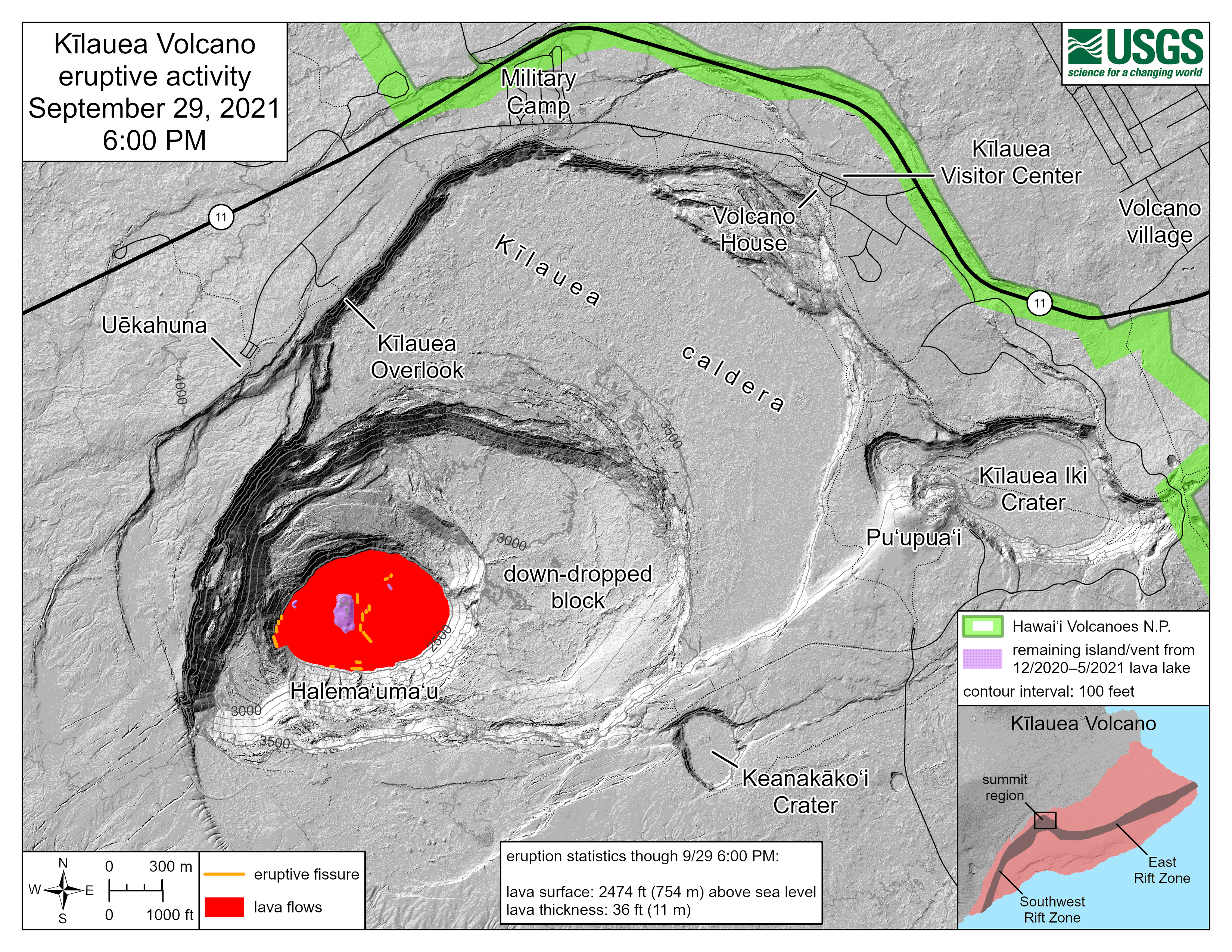
Kīlauea summit eruption reference maps over the past year
Kīlauea summit eruption reference maps over the past yearThis animated gif shows one year of reference maps depicting the ongoing Kīlauea summit eruption, which began on September 29, 2021. The animated gif shows how the active lava lake has decreased in area over the past year, while the crater floor has grown in area.

Kīlauea summit thermal maps over the past year
This animated gif shows one year of thermal maps made from aerial visual and thermal imagery collected of Halema‘uma‘u crater at the summit of Kīlauea. The animated gif shows how the active lava lake has decreased in area over the past year, while the crater floor has grown in area.
This animated gif shows one year of thermal maps made from aerial visual and thermal imagery collected of Halema‘uma‘u crater at the summit of Kīlauea. The animated gif shows how the active lava lake has decreased in area over the past year, while the crater floor has grown in area.

September 29, 2022 — One year of eruption in Halema‘uma‘u, Kīlauea
September 29, 2022 — One year of eruption in Halema‘uma‘u, KīlaueaKīlauea volcano's summit eruption, within Hawai‘i Volcanoes National Park, began one year ago—on September 29, 2021. Image is the cover photo for a three-minute video, produced by the Hawaiian Volcano Observatory, featuring footage from the past year and summarizing the eruption.

KWcam image September 29, 2022, at 11:03 a.m. HST
This image, taken from the KWcam around 11 am on September 29, 2022, shows the lava lake and ongoing eruption within Halemaʻumaʻu crater, at the summit of Kīlauea volcano.
This image, taken from the KWcam around 11 am on September 29, 2022, shows the lava lake and ongoing eruption within Halemaʻumaʻu crater, at the summit of Kīlauea volcano.

Kīlauea summit eruption reference map gif of the past year
Kīlauea summit eruption reference map gif of the past yearThis animated gif shows one year of reference maps depicting the ongoing Kīlauea summit eruption, which began on September 29, 2021. The animated gif shows how the active lava lake has decreased in area over the past year, while the crater floor has grown in area.