
Oregon Waters: Winter 2024
Dear Friends and Partners,
As 2024 draws to a close, we are thrilled to share highlights from an impactful year at the USGS Oregon Water Science Center in our first ever newsletter. Our work continues to advance the understanding of Oregon’s diverse and dynamic water resources. Below, you’ll find a recap of new gage installations, publications, data releases, top news stories, and some projects that shaped 2024.
New gage installations across the state
Our Data and Studies Section field offices worked tremendously hard this year to expand Oregon’s USGS stream gaging network across the state by adding dozens of new gages, a truly staggering feat. In addition, we expanded water-quality data coverage by adding new temperature, turbidity, and dissolved oxygen sensors to several existing stream gages.
Several hydrologic technicians from Portland, Willamette Valley, Eugene, Medford, Bend, and Klamath Falls field offices with support from office staff worked tirelessly to complete these installations. A special thank you to our funding partners who made expanding the gage network possible.
To explore new gage locations please see the links below!
| Site Name | Site Number |
| Big Elk Creek Near Elk City | 14306032 |
| Clackamas River at Big Bottom | 14208000 |
| Clear Creek at Carver | 14210750 |
| Cougar Dam Regulating Outlet Tailrace near Rainbow | 14159405 |
| Collowash River near Breitenbush | 14208300 |
| Crabtree Creek Near Scio | 14188750 |
| Elk Creek at Elkton | 14322810 |
| Fall Creek above Tiller Creek near Lowell | 14150250 |
| Illinois River Near Agness | 14378200 |
| Irving Creek Near Lenz | 11491450 |
| Jackson Creek Near Lenz | 11491470 |
| Keno Reservoir at Keno | 11509380 |
| Klamath River Near Klamath Falls | 11508600 |
| Lake Creek at Swisshome | 14307605 |
| Luckiamute River Near Buena Vista | 14190610 |
| Middle Fork Willamette below Mac Creek near Oakridge | 14144780 |
| Miller Creek Near Beaver Marsh | 11491950 |
| Nehalem River at Jewell | 14300350 |
| North Fork Coquille River Near Myrtle Point | 14327000 |
| North Fork of the Middle Fork Willamette River above Parker Creek near Oakridge | 14147200 |
| North Santiam River below Big Cliff Dam near Detroit | 14181415 |
| North Santiam River at Minto Fish Facility near Gates | 14181650 |
| Sand Creek Below Sand Creek Canal Near Chinchalo | 11492550 |
| Scott Creek Below Sand Creek Canal Near Chinchalo | 11493100 |
| Siletz River Near Siletz | 14305800 |
| Siuslaw River Near Alma | 14306950 |
| Sixes River at Sixes | 14327150 |
| South Fork Coquille River at Myrtle Point | 14326510 |
| South Fork Crooked River near Bell Butte, Near Paulina | 14078260 |
| South Umpqua River at Canyonville | 14308910 |
| South Umpqua River at Melrose | 14312330 |
Learn about stream gages funded by the USGS Next Generation Water Observing Network
-

New gages for understanding surface water availability and spring Chinook salmon habitat in the Willamette Basin
Learn about our new streamgages in the Williamette River Basin.
Highlighted Project Web Pages
-

Understanding Groundwater in Oregon
Oregon Water Resources Department (OWRD) and U.S. Geological Survey (USGS) are working together to estimate groundwater recharge across the state.
Understanding Water Quality Challenges at Bethany Lake: Monitoring Harmful Algal Blooms
The USGS is studying Bethany Lake to provide a comprehensive picture of how the lake’s water conditions and nutrient sources tie into potential algae blooms.
Monitoring sediment transport and aquatic macroinvertebrate communities in the Willamette River basin
The U.S. Geological Survey is listening to rivers to understand how flows transport bedload sediment, which is fundamental to ecosystem structure and health.
Tracking Toxics in the Lower Columbia River
USGS scientists partnered with the Lower Columbia Estuary Partnership (LCEP) to assess toxic contaminant levels at 10 sites within the Lower Columbia River. Our strategy is to compare current toxic contaminant levels to the results collected previously at these sites to identify temporal changes.
Oregon Water Science Center's Malheur Lake Portfolio
USGS scientists have partnered with local groups to learn about the processes affecting turbidity in Malheur Lake. Located in southeastern Oregon, Malheur Lake and the surrounding refuge provide critical habitat to birds migrating along the Pacific Flyway.
Top News Stories:
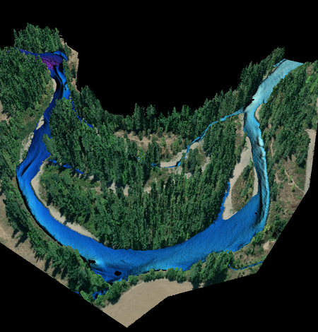
New USGS dataset uncovers the Santiam River’s underwater topography to aid in fish habitat and water flow management
A new dataset for the Santiam River in Oregon, published by the U.S. Geological Survey, provides a highly detailed underwater 3D elevation map that will help support fish habitat restoration and flood modeling work.
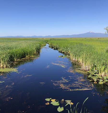
Surface-water extent in the Klamath Marsh
Satellite imagery and the interplay of climate and hydrologic data tell the story of surface-water decline in the Klamath Marsh.
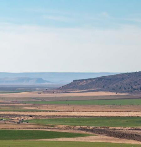
Introducing the Harney Basin groundwater model
Learn about the design, example groundwater pumping scenarios, and limitations of the Harney Basin groundwater model.