
Lava entering the ocean in the vicinity of Kapoho Bay is forming a lava delta, as seen from the air during this morning's overflight at about 7:00 a.m. HST.
All Multimedia
Access all multimedia to include images, video, audio, webcams, before-after imagery, and more. Filter and explore with filtering options to refine search.
Filter Total Items: 24926

Kīlauea Volcano — Ocean Entry Near Vacationland
Lava entering the ocean in the vicinity of Kapoho Bay is forming a lava delta, as seen from the air during this morning's overflight at about 7:00 a.m. HST.
Kīlauea Volcano — Satellite Radar of Crater Slumping
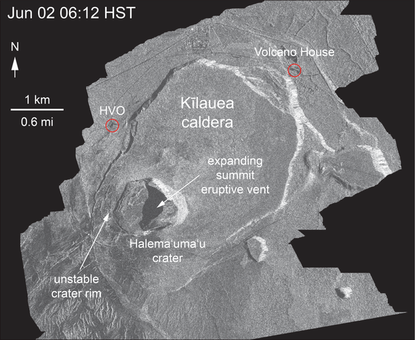
Kīlauea Volcano — Satellite Radar of Crater SlumpingThis animated GIF shows a sequence of radar amplitude images that were acquired by the Italian Space Agency's Cosmo-SkyMed satellite system. The images illustrate changes to the caldera area of Kīlauea Volcano that occurred between May 5 and June 6 at 6:00 a.m. HST.
Kīlauea Volcano — Satellite Radar of Crater Slumping
Kīlauea Volcano — Satellite Radar of Crater SlumpingThis animated GIF shows a sequence of radar amplitude images that were acquired by the Italian Space Agency's Cosmo-SkyMed satellite system. The images illustrate changes to the caldera area of Kīlauea Volcano that occurred between May 5 and June 6 at 6:00 a.m. HST.

Nearshore geophysical mapping
Nearshore geophysical mapping with sub-bottom sled (foreground), personal watercraft equipped with echosounders (background, water) and beach-based personnel (background, beach).
Nearshore geophysical mapping with sub-bottom sled (foreground), personal watercraft equipped with echosounders (background, water) and beach-based personnel (background, beach).

USGS Status Update of Kīlauea Volcano - June 7, 2018
USGS Status Update of Kīlauea Volcano - June 7, 2018USGS Hawaiian Volcano Observatory, Status of Kīlauea Volcano, June 7, 2018. Jessica Ball, USGS Volcanologist.
USGS Status Update of Kīlauea Volcano - June 7, 2018
USGS Status Update of Kīlauea Volcano - June 7, 2018USGS Hawaiian Volcano Observatory, Status of Kīlauea Volcano, June 7, 2018. Jessica Ball, USGS Volcanologist.

Kīlauea LERZ lava flows and fissures, June 6, 12:00 p.m.
Kīlauea LERZ lava flows and fissures, June 6, 12:00 p.m.Map as of 12:00 p.m. (noon) HST, June 6, 2018. Given the dynamic nature of Kīlauea's lower East Rift Zone eruption, with changing vent locations, fissures starting and stopping, and varying rates of lava effusion, map details shown here are accurate as of the date/time noted. Shaded purple areas indicate lava flows erupted in 1840, 1955, 1960, and 2014-2015.

Kīlauea Volcano — Halema`uma`u Explosion (June 6)

Kīlauea Volcano — Kapoho Beach Lots
Views from HVO's helicopter overflight at 1PM HST, show the remains of the Kapoho Beach Lots subdivision and the fissure 8 flow front. The northern flow margin in this area was unchanged from HVO's morning flight and appeared to have stopped advancing at the time of the flight.
Views from HVO's helicopter overflight at 1PM HST, show the remains of the Kapoho Beach Lots subdivision and the fissure 8 flow front. The northern flow margin in this area was unchanged from HVO's morning flight and appeared to have stopped advancing at the time of the flight.

Kīlauea Volcano — Lava Delta at Kapoho Bay
This fish-eye view of the lava delta filling the former Kapoho Bay shows that while the delta margin nearest the ocean has cooled somewhat, the lava flow front is still very hot and producing laze (lava haze). Laze is a local hazard composed of acidic gases and volcanic glass fragments and should be avoided.
This fish-eye view of the lava delta filling the former Kapoho Bay shows that while the delta margin nearest the ocean has cooled somewhat, the lava flow front is still very hot and producing laze (lava haze). Laze is a local hazard composed of acidic gases and volcanic glass fragments and should be avoided.

Kīlauea Volcano — Lava Fountaining (Fissure 8)
The vigorous lava fountain at Fissure 8 reached heights of 45 m (150 ft) as shown in this image taken around 9:30 AM.
The vigorous lava fountain at Fissure 8 reached heights of 45 m (150 ft) as shown in this image taken around 9:30 AM.


Kīlauea Volcano — Lower East Rift Zone
This view, looking south at Kīlauea's lower East Rift Zone, was captured during HVO's 6:00 a.m. HST helicopter overflight today.
This view, looking south at Kīlauea's lower East Rift Zone, was captured during HVO's 6:00 a.m. HST helicopter overflight today.

Kīlauea Volcano — Satellite Imagery Fissure 8
The International Charter for Space and Major Disasters (https://disasterscharter.org/) is a means for space agencies around the world to help with disaster monitoring by providing satellite data to responders and scientists on the ground.
The International Charter for Space and Major Disasters (https://disasterscharter.org/) is a means for space agencies around the world to help with disaster monitoring by providing satellite data to responders and scientists on the ground.
")
Kīlauea Volcano — Thermal Map of Halema`uma`u Crater (June 6, 2018)
Kīlauea Volcano — Thermal Map of Halema`uma`u Crater (June 6, 2018)This 3D thermal map shows the new geometry of Halema‘uma‘u Crater. Magma in the summit magma chamber has drained over the past month due to Kīlauea's lower East Rift Zone eruption, causing much of t

Kīlauea Volcano — USA Overlight of Lower East Rift Zone
Kīlauea Volcano — USA Overlight of Lower East Rift ZoneUnmanned Aircraft Systems (UAS) conducted a mission on Kīlauea Volcano's lower East Rift Zone to collect video of flowing lava in the upper lava channel of fissure 8. Scientists use the video to assess lava flow velocities, which are measured by tracking surface features in the stationary video view.

Kīlauea Volcano — Video Compilation of Lower East Rift Zone
Kīlauea Volcano — Video Compilation of Lower East Rift ZoneThis is a video compilation from a helicopter overflight of Kīlauea Volcano's lower East Rift Zone on June 6, 2018, around 6:30 AM. The video shows the fissure 8 lava fountain feeding a channelized lava flow that travels northeast around the Kapoho cone, and then flows toward the south to enter the ocean at Kapoho Bay and Vacationland.
")
Kīlauea Volcano —Compilation of Lower East Rift Zone (Audio Described)
Kīlauea Volcano —Compilation of Lower East Rift Zone (Audio Described)This is a video compilation from a helicopter overflight of Kīlauea Volcano's lower East Rift Zone on June 6, 2018, around 6:30 AM.
Kīlauea Volcano —Compilation of Lower East Rift Zone (Audio Described)
Kīlauea Volcano —Compilation of Lower East Rift Zone (Audio Described)This is a video compilation from a helicopter overflight of Kīlauea Volcano's lower East Rift Zone on June 6, 2018, around 6:30 AM.

lava is rapidly advancing through communities
How do you keep people safe when lava is rapidly advancing through communities? This was just one of the topics addressed during the Cities on Volcanoes 10 meeting in Naples, Italy, last week. Lava flows recently erupted from Kīlauea Volcano's lower East Rift Zone inundated hundreds of homes in the lower Puna District of Hawai‘i Island.
How do you keep people safe when lava is rapidly advancing through communities? This was just one of the topics addressed during the Cities on Volcanoes 10 meeting in Naples, Italy, last week. Lava flows recently erupted from Kīlauea Volcano's lower East Rift Zone inundated hundreds of homes in the lower Puna District of Hawai‘i Island.

SEM Laboratory
Scientists look at a pollen palynomorph using a scanning electron microscope (SEM).
Scientists look at a pollen palynomorph using a scanning electron microscope (SEM).

USGS Status Update of Kīlauea Volcano - June 6, 2018
USGS Status Update of Kīlauea Volcano - June 6, 2018USGS Hawaiian Volcano Observatory, Status of Kīlauea Volcano, 9:30am HST, June 6, 2018, Jessica Ball, USGS Volcanologist
USGS Status Update of Kīlauea Volcano - June 6, 2018
USGS Status Update of Kīlauea Volcano - June 6, 2018USGS Hawaiian Volcano Observatory, Status of Kīlauea Volcano, 9:30am HST, June 6, 2018, Jessica Ball, USGS Volcanologist

Eighteen Mile Creek at Burt Dam at Burt, NY
Andrew Kowalczk collecting a water quality sample below dam in Eighteenmile Creek at Burt, NY ( 04219768) as part of the Great Lake Restoration Initiative (GLRI).
Andrew Kowalczk collecting a water quality sample below dam in Eighteenmile Creek at Burt, NY ( 04219768) as part of the Great Lake Restoration Initiative (GLRI).

Kīlauea LERZ lava flows and fissures, June 5, 10:00 a.m.
Kīlauea LERZ lava flows and fissures, June 5, 10:00 a.m.Map as of 10:00 a.m. HST, June 5, 2018. Given the dynamic nature of Kīlauea's lower East Rift Zone eruption, with changing vent locations, fissures starting and stopping, and varying rates of lava effusion, map details shown here are accurate as of the date/time noted. Shaded purple areas indicate lava flows erupted in 1840, 1955, 1960, and 2014-2015.