
Bright image: the brightest pixel values throughout the video, useful for identifying the position of maximum wave run-up on the beach, position of all breaking waves, and sea-state.
All Multimedia
Access all multimedia to include images, video, audio, webcams, before-after imagery, and more. Filter and explore with filtering options to refine search.
Filter Total Items: 24926

Whidbey Island video camera bright image
Bright image: the brightest pixel values throughout the video, useful for identifying the position of maximum wave run-up on the beach, position of all breaking waves, and sea-state.

Whidbey Island video camera dark image
Dark image: the darkest pixel values throughout the video, useful for tracking sediment plumes, tracking floating debris, and filtering out breaking waves.
Dark image: the darkest pixel values throughout the video, useful for tracking sediment plumes, tracking floating debris, and filtering out breaking waves.

Whidbey Island video camera timex image
Timex (time-exposure) image: a time-averaged image of all frames, smoothing away surface waves and determining the location of persistent wave-breaking (indicative of shallow sandbars).
Timex (time-exposure) image: a time-averaged image of all frames, smoothing away surface waves and determining the location of persistent wave-breaking (indicative of shallow sandbars).

Whidbey Island video camera variance image
Variance image: the standard deviation of pixel intensity throughout the video, and it is useful for determining how much variation or movement is occurring at a given location.
Variance image: the standard deviation of pixel intensity throughout the video, and it is useful for determining how much variation or movement is occurring at a given location.

Kīlauea LERZ lava flows and fissures, June 3, 11:00 a.m.
Kīlauea LERZ lava flows and fissures, June 3, 11:00 a.m.Map as of 11:00 a.m. HST, June 3, 2018. Given the dynamic nature of Kīlauea's lower East Rift Zone eruption, with changing vent locations, fissures starting and stopping, and varying rates of lava effusion, map details shown here are accurate as of the date/time noted. Shaded purple areas indicate lava flows erupted in 1840, 1955, 1960, and 2014-2015.

Kīlauea Volcano — Advancing Flow
Photo from 7AM helicopter overflight, hovering offshore and looking up the flowfront. Nearly all of the front was active and advancing; advance rates were estimated at an average of 250 feet/hour (76 m/hr), and as of 7AM the flow was 500 yards (457 m) from the ocean.
Photo from 7AM helicopter overflight, hovering offshore and looking up the flowfront. Nearly all of the front was active and advancing; advance rates were estimated at an average of 250 feet/hour (76 m/hr), and as of 7AM the flow was 500 yards (457 m) from the ocean.

Kīlauea Volcano — Advancing Lava Flow
Overflight photo at 7AM HST from offshore looking up the flowfront. Nearly all of the front was active and advancing/spreading.
Overflight photo at 7AM HST from offshore looking up the flowfront. Nearly all of the front was active and advancing/spreading.
Kīlauea Volcano — Halema‘uma‘u Crater Slumping Animation
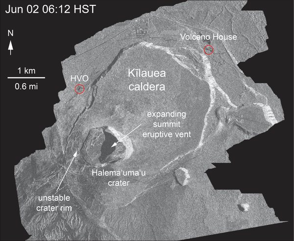
Kīlauea Volcano — Halema‘uma‘u Crater Slumping AnimationThis animated GIF shows a sequence of radar amplitude images that were acquired by the Italian Space Agency's Cosmo-SkyMed satellite system. The images illustrate changes to the caldera area of Kīlauea Volcano that occurred between May 5 and June 2 at 6:00 p.m. HST.
Kīlauea Volcano — Halema‘uma‘u Crater Slumping Animation
Kīlauea Volcano — Halema‘uma‘u Crater Slumping AnimationThis animated GIF shows a sequence of radar amplitude images that were acquired by the Italian Space Agency's Cosmo-SkyMed satellite system. The images illustrate changes to the caldera area of Kīlauea Volcano that occurred between May 5 and June 2 at 6:00 p.m. HST.

Kīlauea Volcano — Ocean Entry at Kapoho Bay

Kīlauea Volcano — Overflight June 3
This video was taken on the June 3 7AM HST helicopter overflight, hovering offshore and looking up the flowfront. Nearly all of the front was active and advancing; advance rates were estimated at an average of 250 feet/hour (76 m/hr), and as of 7AM the flow was 500 yards (457 m) from the ocean.
This video was taken on the June 3 7AM HST helicopter overflight, hovering offshore and looking up the flowfront. Nearly all of the front was active and advancing; advance rates were estimated at an average of 250 feet/hour (76 m/hr), and as of 7AM the flow was 500 yards (457 m) from the ocean.

Kīlauea Volcano — Summit Plume

USGS Status Update of Kīlauea Volcano - June 3, 2018
USGS Status Update of Kīlauea Volcano - June 3, 2018USGS Hawaiian Volcano Observatory status of Kilauea volcano in Hawaii on June 3, 2018. On camera: Jessica Ball, USGS Volcanologist
USGS Status Update of Kīlauea Volcano - June 3, 2018
USGS Status Update of Kīlauea Volcano - June 3, 2018USGS Hawaiian Volcano Observatory status of Kilauea volcano in Hawaii on June 3, 2018. On camera: Jessica Ball, USGS Volcanologist

West view of Fire Island, New York from the Fire Island Lighthouse
West view of Fire Island, New York from the Fire Island LighthouseThe Coastal Sediment Availability and Flux project conducts research and monitoring of sediment movement and coastal change at several barrier islands around the U.S.
West view of Fire Island, New York from the Fire Island Lighthouse
West view of Fire Island, New York from the Fire Island LighthouseThe Coastal Sediment Availability and Flux project conducts research and monitoring of sediment movement and coastal change at several barrier islands around the U.S.

Child "Candling" a Chicken Egg
A child peers at an unfertilized chicken egg at the USGS outreach booth, 2018 Suisun Marsh Field Day. USGS waterfowl ecologists use this method to check the development of a fetal duckling in the field.
*Note: photo taken with permission of parent.
A child peers at an unfertilized chicken egg at the USGS outreach booth, 2018 Suisun Marsh Field Day. USGS waterfowl ecologists use this method to check the development of a fetal duckling in the field.
*Note: photo taken with permission of parent.

ID Bands for Suisun Waterfowl
USGS scientists attach small metal bands, each with its own ID, to the ankles of adult waterfowl to identify where the animal was caught. When it is re-captured later in its migration, researchers can use that information to determine how far the animal traveled.
USGS scientists attach small metal bands, each with its own ID, to the ankles of adult waterfowl to identify where the animal was caught. When it is re-captured later in its migration, researchers can use that information to determine how far the animal traveled.

Kīlauea LERZ lava flows and fissures, June 2, 1:30 p.m.
Kīlauea LERZ lava flows and fissures, June 2, 1:30 p.m.Map as of 1:30 p.m. HST, June 2, 2018. Given the dynamic nature of Kīlauea's lower East Rift Zone eruption, with changing vent locations, fissures starting and stopping, and varying rates of lava effusion, map details shown here are accurate as of the date/time noted. Shaded purple areas indicate lava flows erupted in 1840, 1955, 1960, and 2014-2015.

Kīlauea Volcano — `A`ā Flow
East side of the fissure 8 flow on the "lighthouse road" (east of the Four Corners intersection). The ‘a‘ā flow was about 5 m (16 ft) thick when this photo was taken around 2:00 p.m. HST.
East side of the fissure 8 flow on the "lighthouse road" (east of the Four Corners intersection). The ‘a‘ā flow was about 5 m (16 ft) thick when this photo was taken around 2:00 p.m. HST.

Kīlauea Volcano — Documenting Flows
An HVO geologist documents the fissure 8 flow southeast of Four Corners (the intersection of Highways 132 and 137).
An HVO geologist documents the fissure 8 flow southeast of Four Corners (the intersection of Highways 132 and 137).

Kīlauea Volcano — Lava Flowing into Green Lake

Kīlauea Volcano — Lava Near Four Corners
Northern edge of the fissure 8 flow front on the night of June 1, as it approached the intersection of Highways 132 and 137, known as "Four Corners."
Northern edge of the fissure 8 flow front on the night of June 1, as it approached the intersection of Highways 132 and 137, known as "Four Corners."

Kīlauea Volcano — Night Fountains (Fissure 8)
Overnight (June 1-2), fissure 8 lava fountains decreased to heights of about 50 m (164 feet). The moon can be seen in the upper left.
Overnight (June 1-2), fissure 8 lava fountains decreased to heights of about 50 m (164 feet). The moon can be seen in the upper left.