
A well at a restored prairie on Lake Agassiz beach ridge, Glacial Ridge National Wildlife Refuge
Images
Explore our planet through photography and imagery, including climate change and water all the way back to the 1800s when the USGS was surveying the country by horse and buggy.
Filter Total Items: 21343

Well on Restored Prairie
A well at a restored prairie on Lake Agassiz beach ridge, Glacial Ridge National Wildlife Refuge

western ANWR-1002 Area with ice in Camden Bay
Northward view in western Arctic National Wildlife Refuge-1002 Area with ice in Camden Bay in distance. North sloping, tundra-covered surface is typical of coastal plain.
Northward view in western Arctic National Wildlife Refuge-1002 Area with ice in Camden Bay in distance. North sloping, tundra-covered surface is typical of coastal plain.

western Sadlerochit Mountains near the Tamayariak River
western Sadlerochit Mountains near the Tamayariak RiverView to northeast from western Sadlerochit Mountains near the Tamayariak River. This gently rolling topography is typical of the southern coastal plain.
western Sadlerochit Mountains near the Tamayariak River
western Sadlerochit Mountains near the Tamayariak RiverView to northeast from western Sadlerochit Mountains near the Tamayariak River. This gently rolling topography is typical of the southern coastal plain.

Wetlands, Glacial Ridge National Wildlife Refuge
Ephemeral wetlands at Glacial Ridge National Wildlife Refuge
Ephemeral wetlands at Glacial Ridge National Wildlife Refuge

Will Dougherty carrying snapping turtle
Northeast Region Photo Contest Winner | June 2019 | People
Will Dougherty carrying snapping turtle
Northeast Region Photo Contest Winner | June 2019 | People
Will Dougherty carrying snapping turtle

Yosemite toad caught on camera crossing beneath "toad road" structure
Yosemite toad caught on camera crossing beneath "toad road" structureThis is remote capture image of a Yosemite toad seen crossing beneath "toad road" structure built atop a forest road in the Sierra National Forest. Reseachers are exploring tools, such as this elevated road structure, or "toad road," to reduce vehicle strikes to this threatened species.

Young Moose, Glacial Ridge National Wildlife Refuge
Young Moose, Glacial Ridge National Wildlife RefugeYoung moose near Benoit, Minnesota, Glacial Ridge National Wildlife Refuge
Young Moose, Glacial Ridge National Wildlife Refuge
Young Moose, Glacial Ridge National Wildlife RefugeYoung moose near Benoit, Minnesota, Glacial Ridge National Wildlife Refuge

Taking water quality samples in Alaska
Earl Alstrom and Carol Hasburgh taking water quality samples near St. Mary’s, Alaska.
Earl Alstrom and Carol Hasburgh taking water quality samples near St. Mary’s, Alaska.

Cattaraugus Creek near Springville, NY
Photo Contest Winner | Nov. 2019 | Where We Work
Cattaraugus Creek near Springville, NY
Photo Contest Winner | Nov. 2019 | Where We Work
Cattaraugus Creek near Springville, NY

Crawfish groundwater measurement
Northeast Region Photo Contest Winner | Sept 2019 | USGS at Work
Crawfish groundwater measurement
Northeast Region Photo Contest Winner | Sept 2019 | USGS at Work
Crawfish groundwater measurement

Northern Pintail Drake at Colusa National Wildlife Refuge
Northern Pintail Drake at Colusa National Wildlife RefugeNorthern Pintail Drake at Colusa National Wildlife Refuge
Northern Pintail Drake at Colusa National Wildlife Refuge
Northern Pintail Drake at Colusa National Wildlife RefugeNorthern Pintail Drake at Colusa National Wildlife Refuge

A closer view of the braided section of the Fissure 8 channel, with Highway 132
A closer view of the braided section of the Fissure 8 channel, with Highway 132A closer view of the braided section of the Fissure 8 channel, with Highway 132 cutting across both branches. USGS photo by M. Zoeller.
A closer view of the braided section of the Fissure 8 channel, with Highway 132
A closer view of the braided section of the Fissure 8 channel, with Highway 132A closer view of the braided section of the Fissure 8 channel, with Highway 132 cutting across both branches. USGS photo by M. Zoeller.

Building 1 and Credit Union on USGS Menlo Park campus
Building 1 and Credit Union on USGS Menlo Park campusBuilding 1 formerly housed many different USGS groups, including the Western Coastal and Marine Geology team, but slowly has been leased out to other federal agencies like the Transportation Security Administration (TSA) and Veterans Affairs (VA). At the right is the Menlo Survey Federal Credit Union.

This photo looks north along the broad Fissure 8 channel. At its widest section
This photo looks north along the broad Fissure 8 channel. At its widest sectionThis photo looks north along the broad Fissure 8 channel. At its widest section, the Fissure 8 channel is about 430 meters (1400 feet wide). In the upper right section of the photo, Highway 132 can be seen cutting through the braided section of the channel. USGS photo by M. Zoeller.

USGS Menlo Park campus
Building 3 on the USGS Western Region campus in Menlo Park, California.
Building 3 on the USGS Western Region campus in Menlo Park, California.

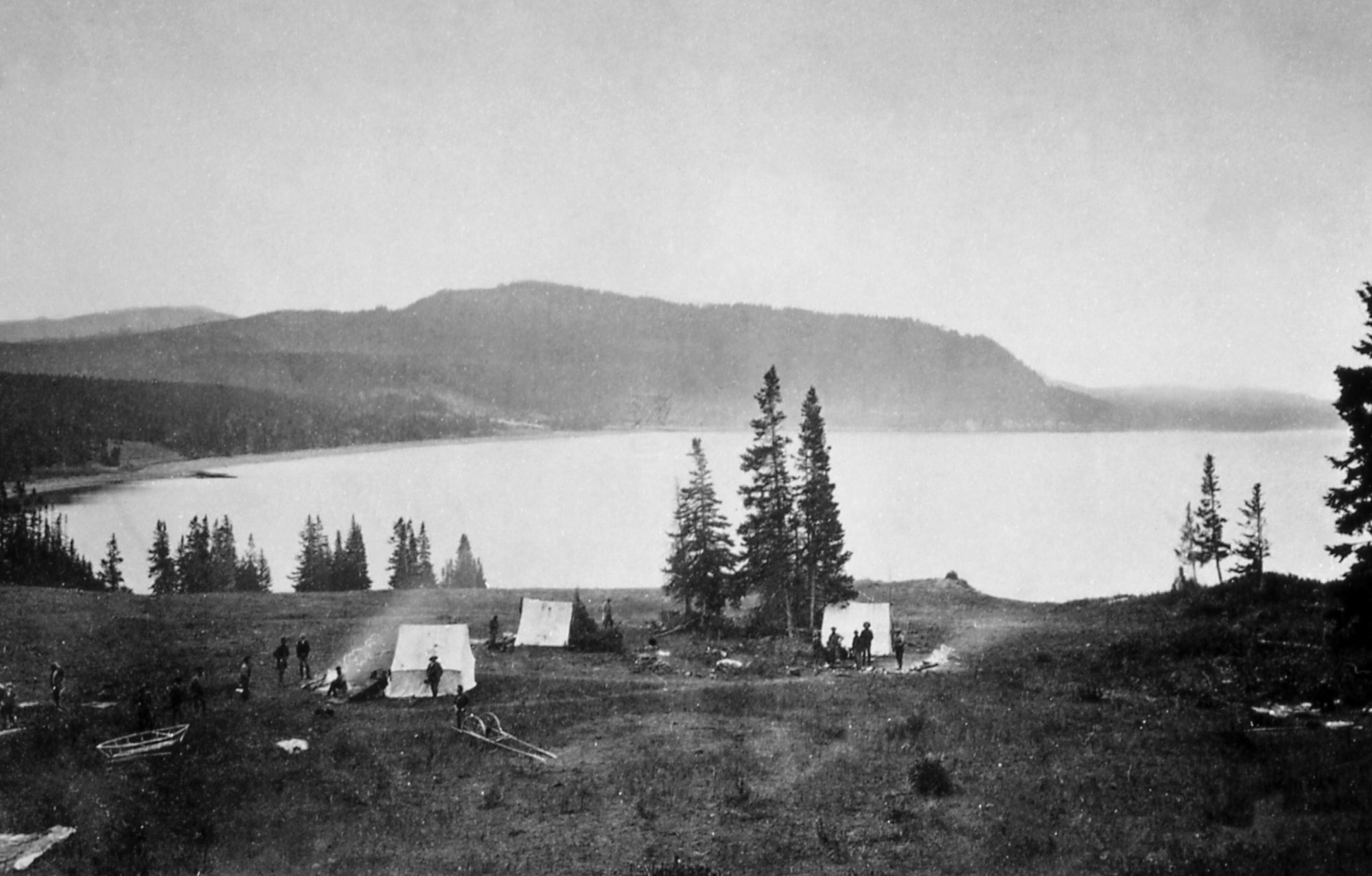
"Earthquake camp" of the Hayden expedition in 1871, located on the north shore o
"Earthquake camp" of the Hayden expedition in 1871, located on the north shore o"Earthquake camp" of the Hayden expedition in 1871, located on the north shore of Yellowstone Lake near Steamboat Point. Photo by William H. Jackson, courtesy Yellowstone National Park (https://www.nps.gov/features/yell/slidefile/history/jacksonphotos/Image…).

Dan Dzurisin
Dan Dzurisin, of the Cascades Volcano Observatory, conducting a leveling survey at Newberry Volcano, Oregon, in 2002.
Dan Dzurisin, of the Cascades Volcano Observatory, conducting a leveling survey at Newberry Volcano, Oregon, in 2002.

Flock of northern pintail ducks at Yolo Bypass Wildlife Area
Flock of northern pintail ducks at Yolo Bypass Wildlife AreaFlock of northern pintail flying at Yolo Bypass Wildlife Area
Flock of northern pintail ducks at Yolo Bypass Wildlife Area
Flock of northern pintail ducks at Yolo Bypass Wildlife AreaFlock of northern pintail flying at Yolo Bypass Wildlife Area

Flock of northern pintail flying at Yolo Bypass Wildlife Area
Flock of northern pintail flying at Yolo Bypass Wildlife AreaFlock of northern pintail flying at Yolo Bypass Wildlife Area
Flock of northern pintail flying at Yolo Bypass Wildlife Area
Flock of northern pintail flying at Yolo Bypass Wildlife AreaFlock of northern pintail flying at Yolo Bypass Wildlife Area

Jo Schmith examining ash from Katla volcano in Iceland
Jo Schmith examining ash from Katla volcano in IcelandJo Schmith examining ash from Katla volcano in Iceland.
Jo Schmith examining ash from Katla volcano in Iceland
Jo Schmith examining ash from Katla volcano in IcelandJo Schmith examining ash from Katla volcano in Iceland.

Lake Ontario
Lake Ontario view from the Queens Royal Park, Ontario, Canada
Lake Ontario view from the Queens Royal Park, Ontario, Canada