
Looking down from the Anne Kolb Nature Center's five-story observation tower
at an extensive mangrove canopy and West Lake.
Images
Explore photos, graphics, and illustrations related to projects from across the CASC Network. And be sure to check out our Climate Illustrations page, featuring free-to-download illustrations that help describe tricky climate concepts and explain how climate change affects the world around us.
Filter Total Items: 639

Mangroves and water
Looking down from the Anne Kolb Nature Center's five-story observation tower
at an extensive mangrove canopy and West Lake.

Tide Pools (Maui)
A classic marine tide pool environment among some of the black lava rocks found on the southern shore of Maui in the Hawaiian islands.
A classic marine tide pool environment among some of the black lava rocks found on the southern shore of Maui in the Hawaiian islands.

View looking up-stream toward Carraizo Dam, under drought conditions
View looking up-stream toward Carraizo Dam, under drought conditionsView looking up-stream toward Carraizo Dam in Loiza, Puerto Rico, under drought conditions.
View looking up-stream toward Carraizo Dam, under drought conditions
View looking up-stream toward Carraizo Dam, under drought conditionsView looking up-stream toward Carraizo Dam in Loiza, Puerto Rico, under drought conditions.

Harry's Ridge monitoring station, 8 km north of Mount St. Helens
Harry's Ridge monitoring station, 8 km north of Mount St. HelensHarry's Ridge monitoring station, 8 km (5 mi) north of Mount St. Helens' crater.
Harry's Ridge monitoring station, 8 km north of Mount St. Helens
Harry's Ridge monitoring station, 8 km north of Mount St. HelensHarry's Ridge monitoring station, 8 km (5 mi) north of Mount St. Helens' crater.

Mount Hood dominates the skyline outside of Portland, OR on a clear...
Mount Hood dominates the skyline outside of Portland, OR on a clear...Mount Hood dominates the skyline outside of Portland, Oregon on a clear day. An major eruption of Mount Hood would pose a great hazard to the regional economy.

Mount Hood in the not-so-far distance beyond Downtown Portland, OR....
Mount Hood in the not-so-far distance beyond Downtown Portland, OR....Mount Hood in the not-so-far distance beyond Downtown Portland, Oregon. Photograph taken at the top of the Portland Aerial Tram line on Marquam Hill.
Mount Hood in the not-so-far distance beyond Downtown Portland, OR....
Mount Hood in the not-so-far distance beyond Downtown Portland, OR....Mount Hood in the not-so-far distance beyond Downtown Portland, Oregon. Photograph taken at the top of the Portland Aerial Tram line on Marquam Hill.
UAS Sign In Desk
Sign in desk, taken at the first Federal Unmanned Aircraft Systems Workshop.
Sign in desk, taken at the first Federal Unmanned Aircraft Systems Workshop.
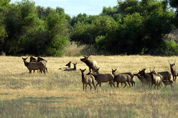
Tule Elk at San Luis National Wildlife Refuge
Tule elk are shown here in their natural habitat at San Luis National Wildlife Refuge; Recovery Act funding will enable the refuge to build a Visitor Center to better serve the public. Related to the R8AF Construct Headquarters Visitor Building San Luis NWR project.
Tule elk are shown here in their natural habitat at San Luis National Wildlife Refuge; Recovery Act funding will enable the refuge to build a Visitor Center to better serve the public. Related to the R8AF Construct Headquarters Visitor Building San Luis NWR project.

Beach of the Great Lakes
Great Lakes water availability studies conducted by the U.S. Geological Survey aim to help characterize how much water the Basin has now, how water availability is changing, and how much water it can expect to have in the future.
Great Lakes water availability studies conducted by the U.S. Geological Survey aim to help characterize how much water the Basin has now, how water availability is changing, and how much water it can expect to have in the future.

Louisiana Black Bear and Cubs
A threatened Louisiana black bear and her cubs up in a tree.
A threatened Louisiana black bear and her cubs up in a tree.


Canoe Landing
Coast Salish Canoe Journey 2009 landing in Pillar Point.
The journey pulled a water quality probe to measure salinity, temperature, pH, and dissolved oxygen.
Coast Salish Canoe Journey 2009 landing in Pillar Point.
The journey pulled a water quality probe to measure salinity, temperature, pH, and dissolved oxygen.

Bison at Yellowstone National Park
Plains bison in winter at Yellowstone National Park.
Plains bison in winter at Yellowstone National Park.

Flat Cays, U.S. Virgin Islands Coral Reef
Shallow coral reefs in the U.S. Virgin Islands are in jeopardy due to climate warming and ocean acidification.
Shallow coral reefs in the U.S. Virgin Islands are in jeopardy due to climate warming and ocean acidification.

Two Cladonia Lichen Species Among Blueberry Plants
Two Cladonia Lichen Species Among Blueberry PlantsTwo Cladonia lichen species, C. stellaris and C. rangiferina are pictured here among some blueberry plants in Newfoundland. Lichens -- which are often mistaken for moss -- are unusual plant-like organisms that are actually symbioses of fungi, algae and bacteria living together.

Prairie Pothole Region
Prairie Pothole Region landscape showing high wetland density.
Prairie Pothole Region landscape showing high wetland density.

Lake Michigan near Grand Haven, Michigan

Climate Change and Snowshoe Hares Winter White Fur
Climate Change and Snowshoe Hares Winter White FurSnowshoe hare experiencing camouflage mismatch in the spring at the Seeley Lake, MT, study site.
Climate Change and Snowshoe Hares Winter White Fur
Climate Change and Snowshoe Hares Winter White FurSnowshoe hare experiencing camouflage mismatch in the spring at the Seeley Lake, MT, study site.

Moraine Lake
Picture of Moraine Lake taken from the south face of South Sister in the Three Sisters Wilderness Area.
Picture of Moraine Lake taken from the south face of South Sister in the Three Sisters Wilderness Area.

Great Smoky Mountains
Great Smoky Mountains National Park
Great Smoky Mountains National Park

Elwah River, Olympic National Park
Picture of the Elwha River in Olympic National Park in Northwest Washington.
Picture of the Elwha River in Olympic National Park in Northwest Washington.