



Regional Super El Niño Impacts: Midwest U.S.
Explore the forecasted impacts of the Super El Niño on the Midwest U.S. and its implications for the management of natural resources.
States covered: Illinois, Indiana, Iowa, Michigan, Minnesota, Missouri, Ohio, and Wisconsin
What Does the Super El Niño Mean for the Midwest U.S.?
Temperature
El Niño winters are commonly, but not always, warmer than usual across the Midwest. The relationship has been most pronounced across Minnesota and Wisconsin with a somewhat weaker response further south and east toward Missouri and Michigan. During recent strong El Niño events, winter temperatures ranged from 3˚F to more than 8˚F warmer than the 20th century average. Some counties in Missouri and Iowa experienced record warmest winters during the 1991–1992 El Niño. Along with generally milder conditions, there is also some evidence that El Niño winters can also lack major cold spells.
Precipitation
El Niño’s influence on Midwest winter precipitation varies across the region. There is a tendency for Michigan, Ohio, and Indiana to be drier than normal during El Niño winters and for parts of Iowa to be wetter than normal. However, there has been variability among past El Niño events.
Lake Ice and Snow
Very cold winters can lead to the development of more extensive lake ice and its persistence into the spring. Warmer winters, often expected during El Niño events should lead to lower ice cover. Prior to the winter of 1997–1998, El Niño winters were more likely to have lower ice cover. Since that time, however, there has been little consistent relationship between Great Lakes ice cover and El Niño. In three of the four recent very strong El Niños, maximum ice cover on each of the Great Lakes was lower, and the maximum ice coverage usually occurred earlier in the year. The 1991–1992 winter was different, with more than average ice cover on Lakes Superior, Huron, and Erie. Dates of maximum ice cover were also much later in the year on Superior and Huron.
| El Niño Winter | Lake Superior | Lake Michigan | Lake Huron | Lake Erie | Lake America | |||||
|---|---|---|---|---|---|---|---|---|---|---|
| AMIC anomaly | Days earlier (-) or later (+) | AMIC anomaly | Days earlier (-) or later (+) | AMIC anomaly | Days earlier (-) or later (+) | AMIC anomaly | Days earlier (-) or later (+) | AMIC anomaly | Days earlier (-) or later (+) | |
| 1983 | -39.4 | -19 | -15.3 | -4 | -31.6 | -24 | -39.7 | -16 | -16.6 | -4 |
| 1992 | 13.7 | 26 | -6.1 | -9 | 6.5 | 27 | 9.3 | -15 | -11.6 | 4 |
| 1998 | -48.5 | -41 | -23.8 | -6 | -34.8 | -19 | -75.1 | -38 | -22.9 | -13 |
| 2016 | -36.9 | -12 | -12.1 | 2 | -15.4 | -11 | -1.8 | -16 | -5.6 | 2 |
El Niño effects on snow can be complex, but with warmer, milder winter conditions, it would be reasonable to expect lower snowfall. Generally, the Midwest receives less snowfall during El Niño winters. A potential complication here is lake-effect snow, produced when cold air moves across unfrozen lakes. Lake-effect snow around Lake Michigan was shown to be lower during El Niño winters, likely because there are fewer cold air outbreaks, but evidence is limited about the impact of E Niño on lake-effect snow.
Learn more about El Niño and snow>>
Comparison of Seasonal Forecast Models for 2026–2027 Winter Weather Conditions in the Midwest Region
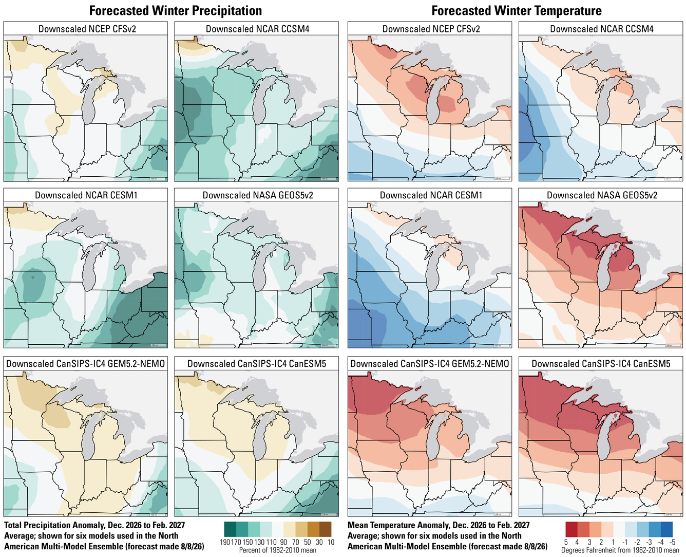
There are differences among seasonal forecast models, and in areas where those differences are larger, confidence in the forecast is lower. We don’t yet know which model will be the most accurate. The six seasonal forecast models used as part of the North American Multi-Model Ensemble display a range of winter precipitation forecasts. Two of the models predict generally drier than normal conditions this winter. Three models predict a wet winter over most of the region, and one model forecasts near-normal precipitation across much of the Midwest. The disagreement indicates uncertainty in winter outcomes, and the differences can be substantial. For example, one model indicates that eastern Ohio could receive more than one and a half times its usual winter precipitation, while another predicts a slightly drier than normal winter. A majority of the models call for a warmer than normal winter across the Upper Midwest, and a majority indicate near to below normal temperatures for Missouri. Winter temperature forecasts are less certain elsewhere in the region. For example, winter temperature predictions for parts of Iowa and Missouri range from a few degrees below normal to a little above normal.
What Does This Mean for the Management of Natural Resources?
Differences between winter forecasts for the Midwest can be challenging for managers, but forecasts combined with current conditions can highlight areas for attention and observation as the fall and winter progress.
For example, parts of the Upper Midwest that are already experiencing drought could see drought remain or worsen if warmer, drier forecasts are correct. Drought can have a range of impacts from enhancing fire risk to reducing water quality, stressing plants and animals, and even potentially hindering river transportation. Many of these impacts of persistent drought may not be fully experienced until the spring.
In the Upper Midwest, there is a reasonably strong signal for warmer than normal temperatures that could lead to a reduction in winter snow and ice. In places where winter snow and ice are common, loss of winter can have a wide range of impacts.
- Reduced snowpack and warming winter may lead to earlier, lower peak flow in northern streams, creating warmer water temperatures that could negatively affect coldwater species such as brook trout.
- Reduced lake ice cover can expose shorelines to erosion and increase winter wave action. This may degrade nearshore fish habitat, which is critical to fish spawning and reproduction. Warmer water and longer ice-free period will likely negatively affect coldwater lake species such as cisco. Warmer temperatures and loss of ice cover can reduce oxygen availability leading to fish kills.
- Warmer winter temperatures and a lack of cold spells will reduce lake ice cover and stability. For ice fishing, this will increase safety risks and shorten the season.
- A warmer winter, especially if there is more precipitation on unfrozen ground, could increase erosion and soil damage from timber-harvest vehicles. This can create downstream impacts if combined with increased precipitation causing runoff to streams and rivers. Managers may face reduced winter access to forest resources in the Upper Midwest.
- Mild winter temperatures and decreased snowpack could increase deer browsing, heightening pressure on plant regeneration.
- In the northern Midwest, where there is greater model agreement for decreased precipitation and increased winter temperatures, insulation, refuge, and camouflage will decline for boreal wildlife like snowshoe hare, ruffed grouse, and spruce grouse.
- A warmer winter will likely create more suitable conditions for pests and pathogens, leading to expansion and increased pressure.
- Tick survival, presence, and pathogen transmission are likely to increase in warmer winter conditions in the Midwest. Winter tick infestations on moose, and associated mortality risks, will be of greater concern in a warmer winter.
- Decreased extreme cold and overall mild winter will increase the survival, prevalence, and potentially facilitate the expansion of emerald ash borer and other forest and agriculture pests.
Questions?
Contact the Midwest CASC if you’d like to discuss this El Niño and adaptation strategies for management of your resources.