



Regional Super El Niño Impacts: North Central U.S.
Explore the forecasted impacts of the Super El Niño on the North Central U.S. and its implications for the management of natural resources.
States covered: Colorado, Kansas, Montana, Nebraska, North Dakota, South Dakota, and Wyoming
What Does the Super El Niño Mean for the North Central U.S.?
Winter Temperatures
One of the clearest historical signals during strong El Niño winters is a tendency toward above-average temperatures across the northern tier of the United States, including Montana, Wyoming, and the Dakotas. NOAA's historical analyses show particularly consistent warmth across the Dakotas. For example, during moderate-to-strong El Niño episodes, December–February temperatures in North Dakota have been 3-5°F above normal, with temperatures falling in the warmest third of the historical record during most events. The warm signal has also extended into Nebraska and Kansas, although the magnitude and consistency are generally greater farther north. Given the added warming from climate change, there is a real potential for a record warm winter for 2026–27 in the North Central U.S.
Precipitation and Snow
The historical precipitation response across the North Central region is much more variable than the temperature response and shows a pronounced north–south gradient. Strong El Niño winters have generally been associated with wetter conditions across the southern portion of the region, including Colorado, Nebraska, and Kansas, while portions of Montana, northern Wyoming, and the Northern Plains have more often experienced near-normal to below-normal precipitation. NOAA's historical composites show that the precipitation response in places such as North Dakota is not particularly consistent from one El Niño event to another.
Snow responses similarly vary across the region. Strong El Niño winters have historically brought increased snowfall across the Southern Rockies, including Colorado, while warmer and/or drier conditions farther north can reduce snow accumulation and contribute to earlier snow loss. Because snowfall depends on both precipitation and temperature, the historical precipitation signal should not be interpreted as a direct snowfall signal.
Learn more about El Niño and snow>>
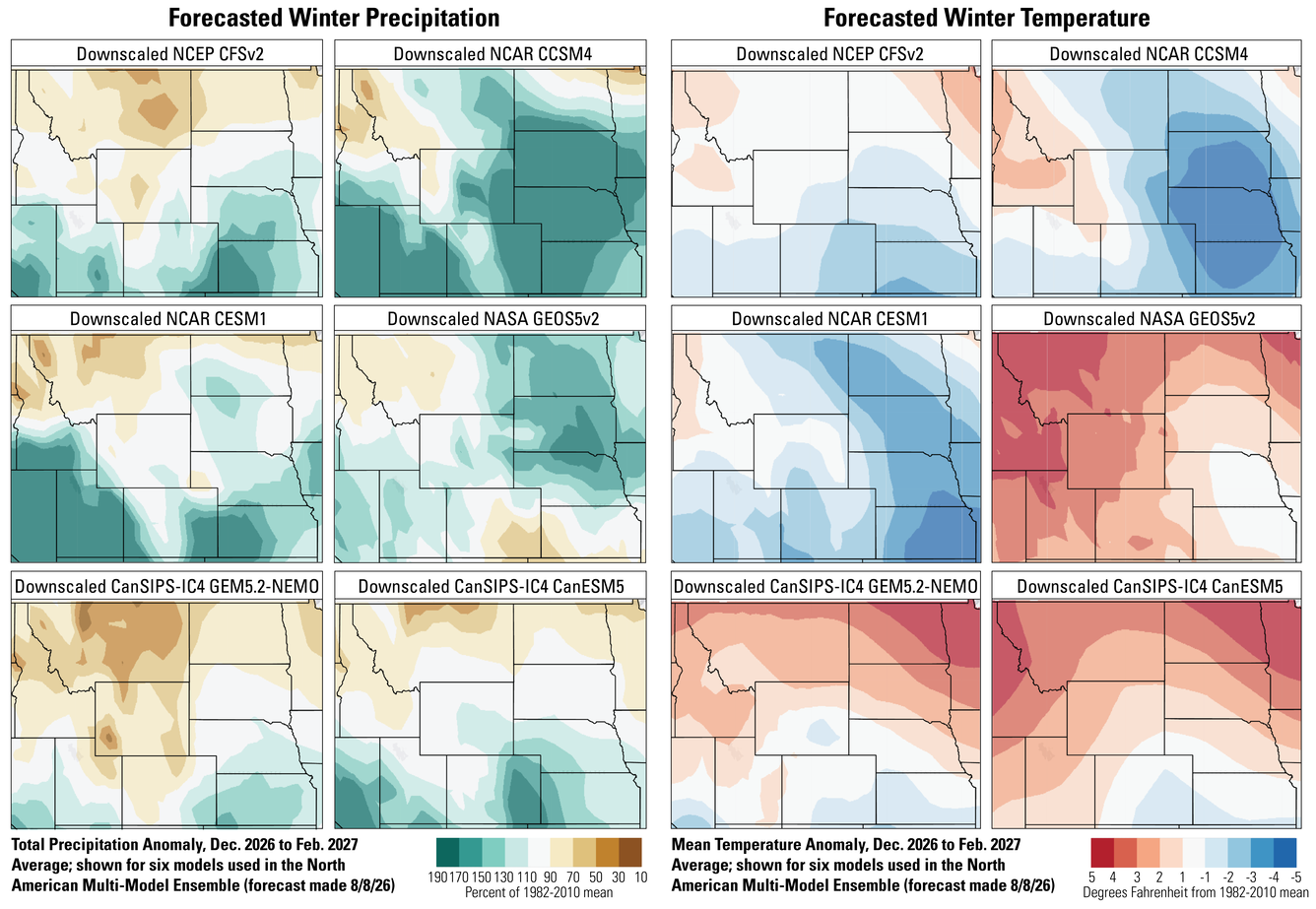
Comparison of Seasonal Forecast Models for 2026–2027 Winter Weather Conditions in the North Central Region
There are differences among seasonal forecast models, and in areas where those differences are larger, confidence in the forecast is lower. We don’t yet know which model will be the most accurate. Overall, the six seasonal forecast models used as part of the North American Multi-Model Ensemble show considerably more agreement on temperature than on precipitation. Most of the models indicate above-average winter temperatures across the northern tier of the North Central region, particularly Montana and the Dakotas, making warmth the most consistent signal in the current forecast. This is also broadly consistent with the historical response during strong El Niño winters. The models show substantially greater disagreement in Colorado, Wyoming, Nebraska, and Kansas, although warmer conditions remain a plausible outcome across much of the region particularly given the additional warming from climate change.
The precipitation forecasts show a weaker but still recognizable pattern: more models favor wetter-than-normal conditions across the southern and central portions of the region, particularly Colorado, Nebraska, and Kansas, while precipitation forecasts are more mixed across Montana, northern Wyoming, and the Dakotas. This general pattern is consistent with the historical tendency for El Niño to shift the winter storm track southward, increasing precipitation across the southern tier while reducing storminess across portions of the Northern Rockies. However, the differences among the models are substantial enough that precipitation should be considered a lower-confidence component of the forecast. The model comparison therefore supports a higher-confidence message about warmth in the northern tier and a lower-confidence, north–south gradient in precipitation. Differences among the models are themselves useful information: where the models diverge, confidence in the seasonal forecast is lower, and the winter may be strongly influenced by other atmospheric patterns and individual storm tracks.
Spring/Summer 2027 Seasonal Forecast
There is substantially less confidence in what El Niño will mean for the North Central region during spring and summer 2027. The influence of ENSO on North American climate is strongest during winter and can persist into early spring, but the relationship becomes considerably weaker and less consistent during the late spring and summer. NOAA therefore cautions against extending the winter El Niño pattern directly into the following warm season.
Winter conditions could nevertheless influence spring and summer resource conditions through their effects on snowpack, soil moisture, streamflow, and water storage. A wetter and snowier winter in the Southern Rockies could increase water availability into spring and potentially benefit ecosystems and water supplies, while a warmer and drier winter in the Northern Rockies could produce reduced snowpack and earlier snowmelt. Similarly, wetter winter conditions across Nebraska and Kansas could increase spring soil moisture, although excessive precipitation could also increase flooding or erosion risks. These are antecedent-condition effects rather than direct predictions of summer climate. By spring and especially summer, the state of ENSO, snowpack, soil moisture, and other sources of atmospheric variability should be reassessed before making resource-management decisions for the 2027 warm season.
What Does This Mean for the Management of Natural Resources?
The strongest management signal for the North Central region is the possibility of warmer winter conditions across the northern tier, combined with north–south differences in precipitation and snow. Managers in Montana, northern Wyoming, and the Dakotas should consider the potential for reduced snow accumulation and earlier snowmelt, particularly at lower and middle elevations where warmer temperatures can shift precipitation from snow to rain and accelerate loss of existing snowpack. This could affect spring runoff timing, soil moisture, water availability, and cold-season habitat conditions. At the same time, managers in Colorado, Kansas, and Nebraska should be prepared for the possibility of wetter-than-normal winter conditions and, at higher elevations in Colorado, increased snow accumulation. Increased precipitation can improve water availability and soil moisture but can also increase the potential for flooding, erosion, rain-on-snow events, and other impacts from individual high-precipitation storms.
These conditions also have implications for vegetation and wildfire management. A wet winter and increased spring moisture can benefit plant growth and water availability, but in water-limited ecosystems, greater winter and spring moisture can also produce more grass and herbaceous biomass that becomes available as fine fuel later in the summer. Conversely, reduced mountain snowpack and earlier snowmelt in the northern part of the region could contribute to earlier drying of soils and vegetation. Because the precipitation signal is considerably less consistent than the temperature signal, managers should avoid treating the El Niño outlook as a deterministic forecast. Instead, it can be used to identify plausible shifts in risk and opportunities for early preparation, while updating decisions as the information on winter precipitation, snowpack, and soil moisture become more certain.
Questions?
Contact the North Central CASC if you’d like to discuss this El Niño and adaptation strategies for the management of your resources.