



Regional Super El Niño Impacts: Northwest U.S.
Explore the forecasted impacts of the Super El Niño on the Northwest U.S. and its implications for the management of natural resources.
States covered: Idaho, Oregon, and Washington
What Does the Super El Niño Mean for the Northwest U.S.?
Winter Storms and Atmospheric Rivers
The Pacific Northwest receives most of its precipitation during the fall, winter, and spring courtesy of mid-latitude storms that develop over the Pacific Ocean. Because the storm track is generally shifted southward during El Niño events, fewer storms impact Oregon, Washington, and Idaho. As a result, El Niño winters are expected to be drier than normal over most of the region, but there are some exceptions. In southern Idaho, southeastern Oregon and in the lee of the Washington Cascades, precipitation is not consistently influenced by El Niño. There have also been several notable exceptions to the expected El Niño pattern. The winters of 1982–1983 and 2015–2016, both very strong El Niños, were wetter than normal across much of the Northwest. Although the winter of 1997–1998 was dry over northern Idaho, coastal Oregon and Washington received near- to above-normal precipitation.
There is not a strong relationship between El Niño and winter precipitation from atmospheric rivers (ARs) impacting the Northwest, so it is difficult to predict what to expect. However, multiple studies show the potential for increased AR activity off the Washington and Oregon coast during El Niño events, potentially raising precipitation potential for coastal mountains. Significant ARs have impacted the Northwest during previous El Niño events. For example, a major AR delivered heavy precipitation and triggered flooding in November 2015.
Snow
El Niño winters are often, though not always, warmer than normal in the Northwest, as well as drier, raising concerns that the coming winter snowpack may be less robust than normal. This may be particularly true in parts of the Northwest, such as the Cascades and lower elevations of the interior, that are relatively warm and receive snow at temperatures near freezing. Although it is the temperature during storms rather than overall seasonal temperatures that matters for snowfall, lower-snow winters are more common during El Niño events.
Learn more about El Niño and snow>>
Comparison of Seasonal Forecast Models for 2026–2027 Winter Weather Conditions in the Northwest Region
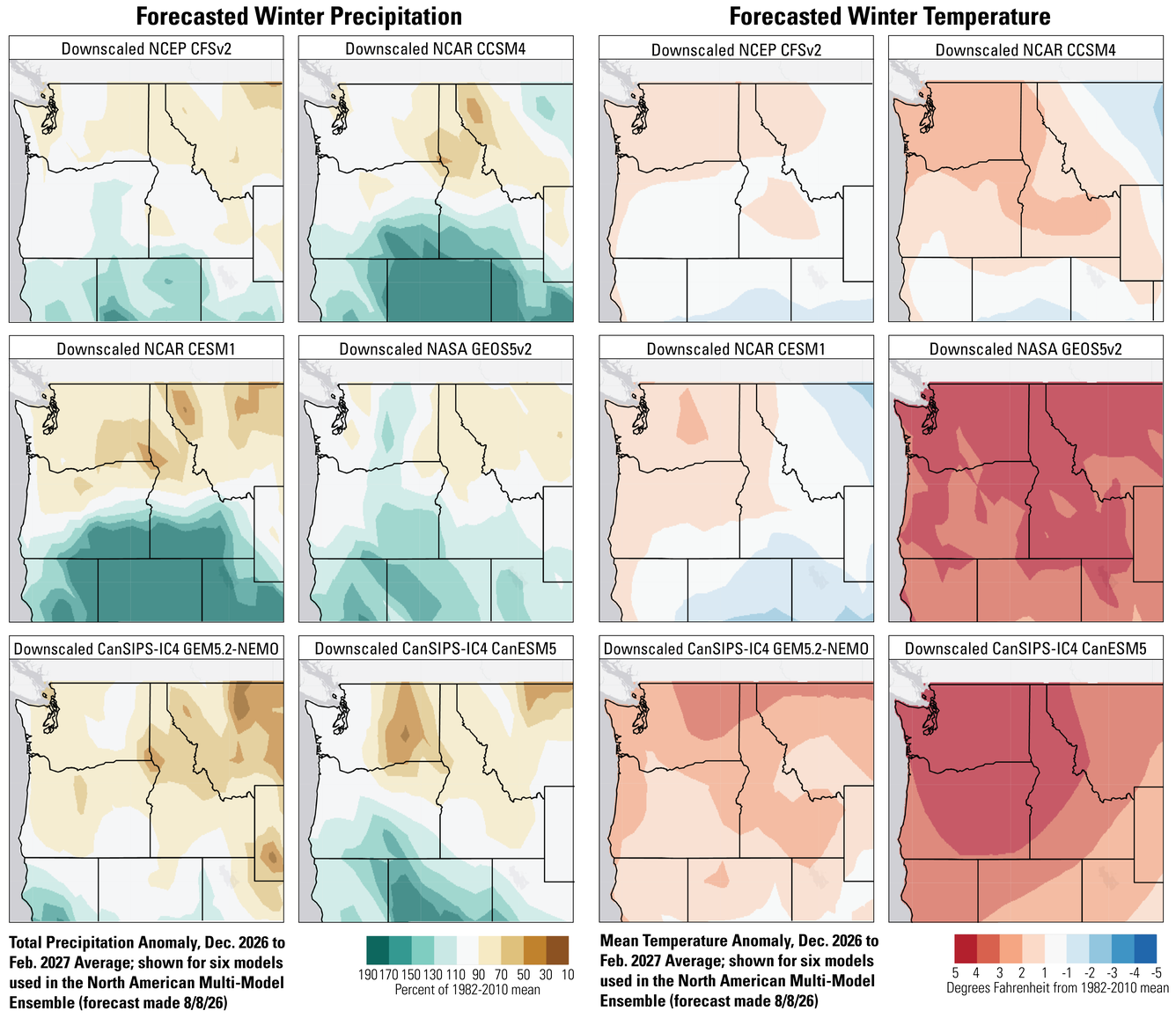
There are differences among seasonal forecast models, and in areas where those differences are larger, confidence in the forecast is lower. We don’t yet know which model will be the most accurate. The six seasonal forecast models used as part of the North American Multi-Model Ensemble forecast slightly drier than normal conditions over the northern part of the Northwest, with predictions for deeper precipitation deficits over northern Idaho. There is less agreement among models over southern Oregon and Idaho where forecasts range from very wet to slightly drier than normal. There is greater agreement about the temperature forecast, with most models predicting a warmer than normal winter. However, forecasts range from near normal to more than 5˚F above normal. For comparison, the long-term average spring temperature in Spokane is about 7˚F warmer than the average winter temperature.
What Does This Mean for the Management of Natural Resources?
Large portions of the Northwest are currently experiencing drought, including extreme and exceptional drought in central Oregon and southern Idaho. Currently, winter forecasts call for below-normal winter precipitation and warmer than normal temperatures over much of the region, though about half of the models suggest a wetter than normal winter in southeastern Oregon. If the largely warm and dry forecasts are accurate, drought is likely to persist or worsen, raising concerns about water resources, poor rangeland forage production, and the potential for another significant fire season in 2027.
Many resource management decisions can be made in response to actual winter conditions. Regional managers can monitor conditions and make many decisions later in the season with more concrete information. Some decisions for next spring and summer, such as purchasing seed or seedlings for restoration, need to be made several months in advance, and seasonal forecasts may provide some guidance.
Irrespective of overall seasonal precipitation, winter in the Northwest is likely to include some severe storms with heavy rain in warmer locations, snowfall in the mountains, and the potential for rain-on-snow events. Planning for winter weather, including confirming weblinks for local National Weather Service Offices, River Forecast Offices, and USGS stream gages can help managers stay informed of developing hazards.
Questions?
Contact the Northwest CASC if you’d like to discuss this El Niño and adaptation strategies for management of your resources.