



Regional Super El Niño Impacts: Southwest U.S.
Explore the forecasted impacts of the 2026 El Niño on the Southwest U.S. and its implications for the management of natural resources.
States covered: Arizona, Utah, California, and Nevada
What Does El Niño Mean for the Southwest U.S.?
Winter Storms and Atmospheric Rivers
The Southwest receives most of its late autumn and winter precipitation from mid-latitude storms steered into the region by the jet stream. During many El Niño winters, the jet stream across the Pacific Ocean shifts farther south and swings north less often. When the jet stream is further south, more storms are delivered to the southern parts of the United States. As a result, parts of the Southwest—Southern and Central California, much of Arizona, southern Nevada, and southeastern Utah—are often wetter than normal during El Niño winters. Often is not always, though. The so-called “Godzilla El Niño” winter of 2015–2016 resulted in drier than normal conditions in Southern California and Arizona and wetter conditions across almost all of Nevada. For other parts of the southwest, El Niño is not helpful in forecasting winter rain and snow; northern California, much of Nevada, and northern and western Utah can have wet, dry, or normal winters during El Niño.
One of the reasons El Niño winters do not always deliver the expected wet or dry conditions in the Southwest region is atmospheric rivers, which are especially big producers of precipitation across this region. Atmospheric rivers are narrow bands of very wet air that can develop with storms. The number, location, and even angle of atmospheric rivers can influence how much rain or snow parts of the Southwest get in any given winter. Unfortunately, El Niño is not a strong predictor of atmospheric rivers across the Southwest, which limits predictability of these types of storm events.
Snow
The relationship between snow and El Niño is complicated. Storms have to be cold enough for the precipitation to fall as snow rather than rain. Just looking at the seasonal temperature and precipitation outlooks, based in part on El Niño, does not necessarily shed light on snowfall. While maps of average January to March snowfall suggest that El Niño winters are much snowier than normal, these averages reflect a small number of winters and can be skewed by a couple of seasons with exceptionally heavy snowfall. Counting the number of snowy El Niño winters tells a different story—most locations don’t receive “above average” snowfall during El Niño events but are more likely to get a little or a lot. For example, the Central Sierra Snow Lab near Donner Pass in California received above average snowfall in half of the El Niño winters since 1950 and below average snowfall in the others. Among the four strongest El Niños this region has experienced, two had above normal snowfall and two below average. Data from the Central Sierra Snow Lab are available at https://cssl.berkeley.edu/data.
Learn more about El Niño and snow>>
Hurricanes
An active Pacific hurricane season is more likely during El Niño. Warmer waters in the tropical Pacific and low vertical wind shear help intensify storms. Partly because of the current El Niño, this year’s Eastern Pacific hurricane outlook anticipates more tropical storms, hurricanes, and major hurricanes than usual. Landfalling hurricanes are not common in the Southwest, but hurricanes and tropical storms can increase the chances of autumn precipitation, especially in southern California.
Learn more about El Niño and hurricanes>>
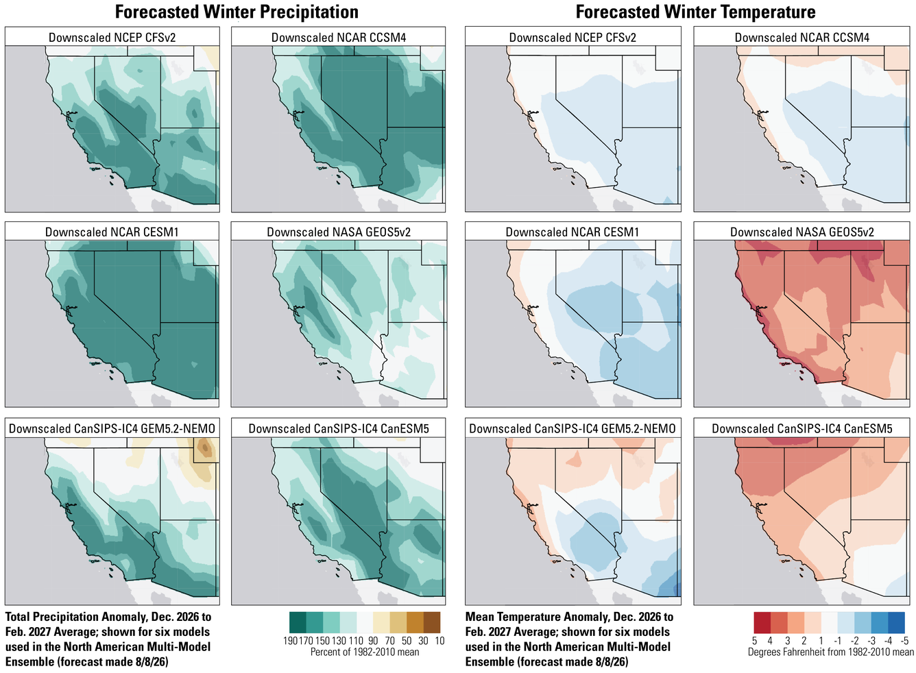
Comparison of Seasonal Forecast Models for 2026–2027 Winter Weather Conditions in the Southwest Region
There are differences among seasonal forecast models, and in areas where those differences are larger, confidence in the forecast is lower. We don’t yet know which model will be the most accurate. Overall, the six seasonal forecast models used as part of the North American Multi-Model Ensemble tend to agree that winter will be wetter than normal over much of the Southwest, with a couple of models indicating normal or dry conditions over parts of northern Utah and Nevada. Some models are currently forecasting close to twice the normal December–February precipitation over large portions of the region. Temperature forecasts show somewhat less agreement. Two models predict below-normal winter temperatures over much of the region, two models predict a warmer than normal winter over most or all of the region, and two models forecast cooler conditions to the south and warmer than normal conditions to the north.
What Does this Mean for the Management of Natural Resources?
El Niño does not provide guarantees about fall and winter weather. However, El Niño makes wetter than normal conditions more likely in southern parts of the Southwest. Key management questions involve water resources, moisture availability for plant growth, and the potential for extreme storms.
A wetter than normal winter could help ease drought impacting much of the Southwest, potentially helping to replenish water supplies and providing moisture for plant growth and wildlife. High precipitation can reduce fire risk in some locations, particularly when accumulates into deeper snowpack. Conversely, non-forested areas may see an increase in fire risk after wet winters because ample precipitation can encourage better growth of grasses, forbs, and fine fuels that dry out quickly in the region’s generally hot and dry summers, thus leading to potentially more fuel for wildfire. Winter precipitation forecasts remain mixed but suggest wetter conditions are more likely over the Upper Colorado River Basin.
Water resources and growing-season soil moisture depend on the cumulative precipitation and/or snowpack over the winter. Many resource managers in the region will likely monitor precipitation conditions and make decisions later in the season with more concrete information. However, some decisions for next spring and summer, such as purchasing seed or seedlings for restoration, need to be made several months in advance and seasonal forecasts may provide some guidance.
Storms associated with above average rainfall can trigger river and coastal flooding, and rain-on-snow events can increase the potential for avalanches and erosion. Rain-on-snow events in areas with deeper-than- average winter snow depths combined with earlier onset of warm spring temperatures can quickly destabilize snowpack, releasing more water in a short duration of time that could exacerbate avalanches, flooding and erosion, particularly if the ground remains frozen and the meltwater cannot be absorbed by soils. Managers can use information about the potential for extreme weather during El Niño to consider response plans.
Questions?
Contact the Southwest CASC if you’d like to discuss this El Niño and adaptation strategies for management of your resources.