
South Cascade Glacier Active
South Cascade Glacier is located in the midlatitude maritime climate of the North Cascade Mountains of Washington State. Glacier observations began at this site in 1958.
Return to Glaciers and Climate Project
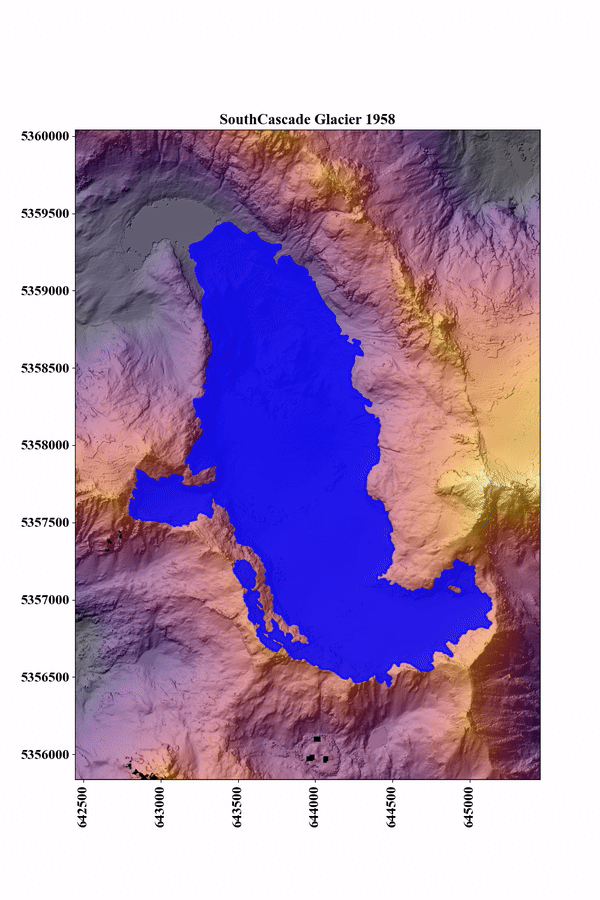
South Cascade Glacier located in a north-northwest facing valley near the crest of the Cascade Range in northwest Washington state. Dominated by a maritime climate, the glacier receives heavy annual precipitation, exceeding 4.5 m in places (PRISM Climate Group, 2006) and is heavily influenced by climate conditions in the Pacific Ocean (Walters and Meier, 1989). In 2015, South Cascade glacier had an area of 1.8 km2 in the 6.14 km2 South South Cascade Lake Basin (O'Neel et al, 2019). The glacier spans nearly 660 m in elevation in the steep sided basin which forms the headwaters of the South Fork of the Cascade River.
In 1959 scientists with the USGS began collecting mass balance data on South Cascade Glacier, one of four "benchmark glaciers" in the US. R Repeated point measurements at established index sites, in conjunction with local meteorology and runoff data, are used to estimate glacier-wide mass balances. These data constitute the longest continuous set of mass-balance data in North America (Josberger and others, 2007) which are used to understand glacier dynamics and hydrology, and to measure the glacier's response to climate change.
Research

Glacier mass balance
In 1959 the USGS began a suite of continuous mass balance measurements at South Cascade Glacier, one of four benchmark glaciers in North America. Extensive glaciological measurements within the basin include: streamflow runoff, precipitation, air temperature, barometric pressure, snow thickness and density, ice ablation, surface speed, and surface altitude. Multiple site visits are made annually for facility maintenance, instrument repair and installation, and direct measurement of snow and ice. There are six stakes dispersed along a center transect from the terminus to the head of the glacier where measurements of ice ablation, and snow depth and density are repeated annually.
Direct field measurements are combined with weather data and imagery analyses to calculate the seasonal and annual mass balance of each glacier. Access all the data here.
Meteorologic
Meteorological observations began in 1959 with installation of temperature and precipitation instruments at several locations in the basin. At the Salix Creek and Middle Tarn gaging station air temperature is measured with thermistor-based sensors in passively ventilated radiation shields, between 3-3.5 m above the ground. At the Hut, air temperature, wind speed, and incoming solar radiation are measured about 1.5 m above the roof.
Air temperature at a constant height of 2.0 m above the glacier surface has also been collected during summer months for a portion of the period of record at South Cascade Glacier.
Liquid precipitation is measured by means of tipping bucket rain gage at Salix and Middle Tarn gaging stations. These unheated gages do not account for precipitation in the form of snow so the record of precipitation at both sites is limited to summer catch.
Current data available from the South Cascade weather station (USGS 12181110) includes:

- Temperature, air
- Wind direction
- Wind speed
- Precipitation
- Solar Radiation
Hydrologic
Runoff from Middle Tarn basin was computed from discharge of the South Fork of the Cascade River where it empties from Middle Tarn. Details of calculations and determination of rating curves can be found in USGS summaries of balance years.
Previous Work
South Cascade glacier, the site of one of North America's longest glacier mass balance records, has been the focus of many facets of glacier research over the years. The world's first radio-echo sounding measurements in temperate ice were conducted on South Cascade Glacier and subglacial water flow have been studied on this glacier, among various other studies aimed at advancing the understanding glaciers. Past data and observations of snow and ice changes on South Cascade Glacier can be found in the collection of USGS Scanned Field Notebooks from South Cascade Glacier, Washington, 1957 - 2022. More Info South Cascade Glacier | Glaciers of the American West

Glaciers and Climate Project
South Cascade Glacier is located in the midlatitude maritime climate of the North Cascade Mountains of Washington State. Glacier observations began at this site in 1958.
Return to Glaciers and Climate Project
South Cascade Glacier located in a north-northwest facing valley near the crest of the Cascade Range in northwest Washington state. Dominated by a maritime climate, the glacier receives heavy annual precipitation, exceeding 4.5 m in places (PRISM Climate Group, 2006) and is heavily influenced by climate conditions in the Pacific Ocean (Walters and Meier, 1989). In 2015, South Cascade glacier had an area of 1.8 km2 in the 6.14 km2 South South Cascade Lake Basin (O'Neel et al, 2019). The glacier spans nearly 660 m in elevation in the steep sided basin which forms the headwaters of the South Fork of the Cascade River.
In 1959 scientists with the USGS began collecting mass balance data on South Cascade Glacier, one of four "benchmark glaciers" in the US. R Repeated point measurements at established index sites, in conjunction with local meteorology and runoff data, are used to estimate glacier-wide mass balances. These data constitute the longest continuous set of mass-balance data in North America (Josberger and others, 2007) which are used to understand glacier dynamics and hydrology, and to measure the glacier's response to climate change.
Research
Glacier mass balance
In 1959 the USGS began a suite of continuous mass balance measurements at South Cascade Glacier, one of four benchmark glaciers in North America. Extensive glaciological measurements within the basin include: streamflow runoff, precipitation, air temperature, barometric pressure, snow thickness and density, ice ablation, surface speed, and surface altitude. Multiple site visits are made annually for facility maintenance, instrument repair and installation, and direct measurement of snow and ice. There are six stakes dispersed along a center transect from the terminus to the head of the glacier where measurements of ice ablation, and snow depth and density are repeated annually.
Direct field measurements are combined with weather data and imagery analyses to calculate the seasonal and annual mass balance of each glacier. Access all the data here.
Meteorologic
Meteorological observations began in 1959 with installation of temperature and precipitation instruments at several locations in the basin. At the Salix Creek and Middle Tarn gaging station air temperature is measured with thermistor-based sensors in passively ventilated radiation shields, between 3-3.5 m above the ground. At the Hut, air temperature, wind speed, and incoming solar radiation are measured about 1.5 m above the roof.
Air temperature at a constant height of 2.0 m above the glacier surface has also been collected during summer months for a portion of the period of record at South Cascade Glacier.
Liquid precipitation is measured by means of tipping bucket rain gage at Salix and Middle Tarn gaging stations. These unheated gages do not account for precipitation in the form of snow so the record of precipitation at both sites is limited to summer catch.
Current data available from the South Cascade weather station (USGS 12181110) includes:
- Temperature, air
- Wind direction
- Wind speed
- Precipitation
- Solar Radiation
Hydrologic
Runoff from Middle Tarn basin was computed from discharge of the South Fork of the Cascade River where it empties from Middle Tarn. Details of calculations and determination of rating curves can be found in USGS summaries of balance years.
Previous Work
South Cascade glacier, the site of one of North America's longest glacier mass balance records, has been the focus of many facets of glacier research over the years. The world's first radio-echo sounding measurements in temperate ice were conducted on South Cascade Glacier and subglacial water flow have been studied on this glacier, among various other studies aimed at advancing the understanding glaciers. Past data and observations of snow and ice changes on South Cascade Glacier can be found in the collection of USGS Scanned Field Notebooks from South Cascade Glacier, Washington, 1957 - 2022. More Info South Cascade Glacier | Glaciers of the American West