
Mountain glaciers are dynamic reservoirs of frozen water, deeply interconnected with their surrounding ecosystems. Glacier change in North America has major societal impacts, including to water resources, natural hazard risk, tourism disruption, fisheries, and global sea level change. Understanding and quantifying precise connections between changing glaciers, the surrounding landscape and climate is critical to decision makers, land managers, and the public, who are affected by these consequences of glacier change. The USGS Benchmark Glacier Project is aimed at solving complex scientific problems in snow and ice across North America to promote enhanced monitoring, analysis, and prediction of mountain glacier change. Utilizing expertise across USGS, this project combines legacy glacier monitoring with remote sensing and contemporary analytical methods to create novel insight and deliver relevant, actionable science.
2025 Benchmark Glaciers Executive Summary
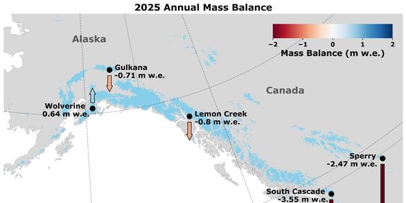
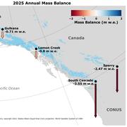
2025 Data Now Available — See how the USGS Benchmark Glaciers have changed this year.
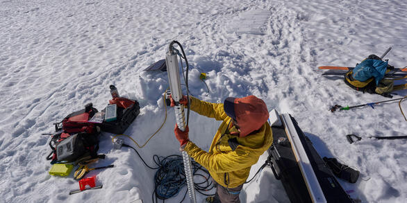
Mass Balance Methods: Measuring Glacier Change
Nearly all of Earth's alpine glaciers are losing mass, with consequences for freshwater resources, landscape stability, regional ecosystems, and global sea level. Rates of glacier mass loss in Western North America and Alaska are among the highest on Earth.
Glacier-Climate Connection

The Glacier-Climate Connection geonarrative tells the story of the U.S. Geological Survey Benchmark Glacier Project, one of the longest running studies of glaciers on Earth.
USGS Benchmark Glacier Project

The flagship research effort of the Glaciers and Climate Project is a multi-glacier, decades-long study of glacier-climate response. Since the 1950s, glacier mass-balance measurements have been systematically collected at five benchmark glaciers, beginning with South Cascade (WA) and later including Gulkana, Wolverine and Lemon Creek Glaciers (AK). Sperry Glacier (MT), monitored since 2005, was added to complete the geographically diverse network in 2013.
Results from this monitoring form the longest continuous record of North American glacier mass balance, which capture seasonal and year-to-year variability. These intensively studied glaciers provide insight into the connection between climate and glaciers at multiple scales.
Historic glacier monitoring has involved various mission areas across USGS, but research was unified into one cohesive program in 2019 (O'Neel and others, 2019). Common field methodologies coupled with long-term, consistently analyzed records, are the hallmark of the Benchmark Glacier Project. Such consistency among sites allows glacier records from different climate zones of North America to be directly compared in order to better understand the impacts of mountain glacier change response of glaciers. Four of the glaciers are considered ‘reference’ glaciers in the World Glacier Monitoring Service’s internationally coordinated glacier monitoring network.
The USGS Benchmark Glacier Project also incorporates data collected from spaceborne and airborne platforms, enabling scientists to document three-dimensional glacier change at regional scales. This application of remotely sensed data broadens the project’s scope and relevance to facilitate glacier change projections, which guide sea level and water resource management strategies.
Benchmark Glaciers
Location of five benchmark glaciers
Gulkana
Lemon Creek
South Cascade
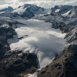
Sperry
Wolverine
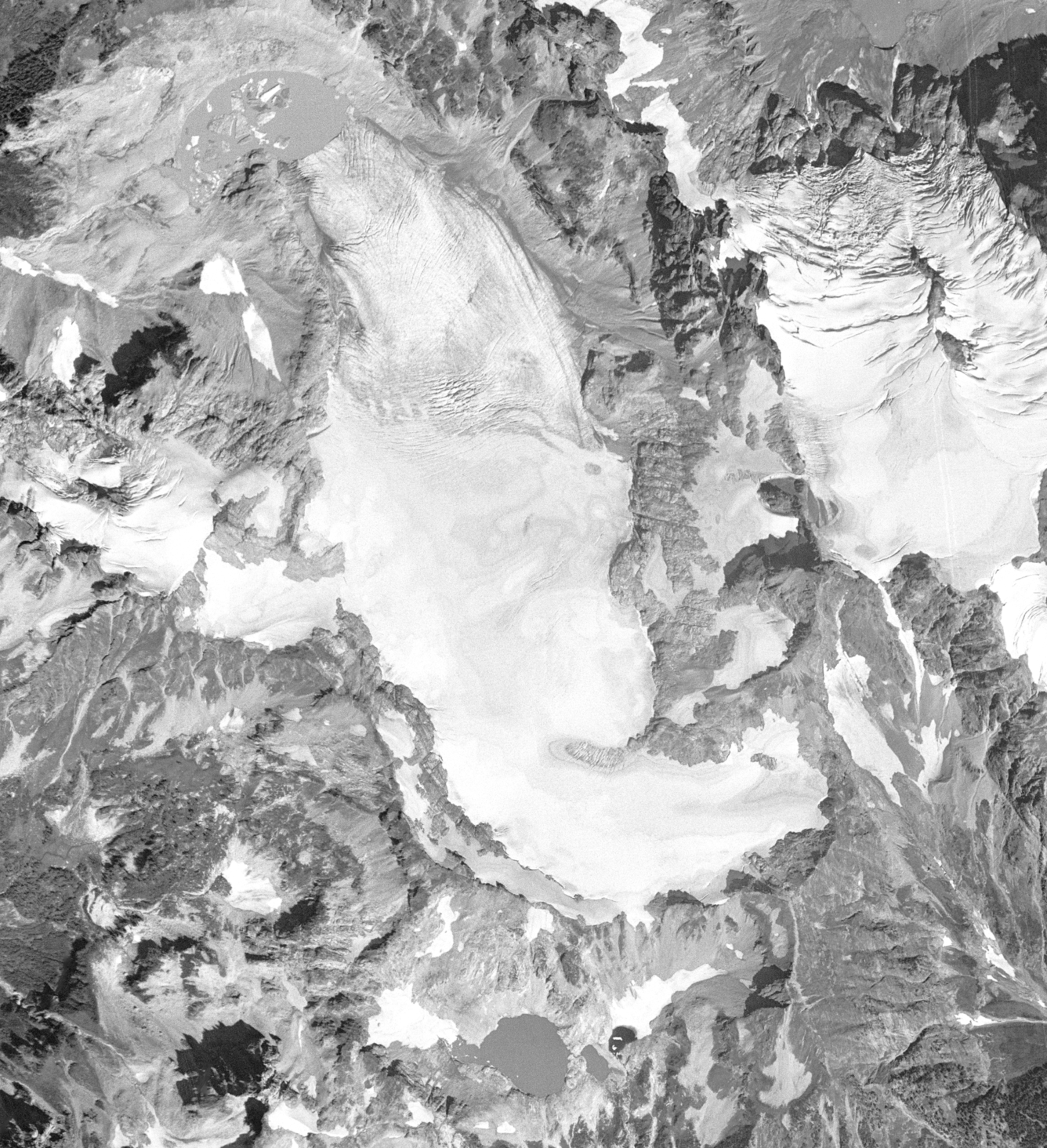
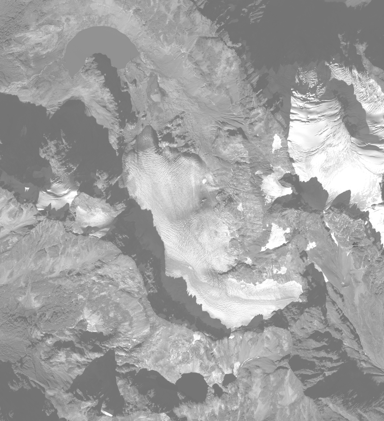
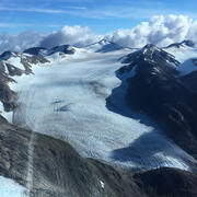
South Cascade Glacier: 57 Years of Change
USGS Research on Additional Glaciers
USGS Benchmark Glacier Research within Global Glacier Studies
2025 USGS Benchmark Glaciers Executive Summary

Mass Balance Methods: Measuring Glacier Change

Additional Research Glaciers

Wolverine Glacier

Gulkana Glacier
Lemon Creek Glacier
South Cascade Glacier

Sperry Glacier

Analyzing North American Glacier Change

Biogeochemistry of glaciers

Time Series of Glacier Retreat

Status of Glaciers in Glacier National Park
Mountain glaciers are dynamic reservoirs of frozen water, deeply interconnected with their surrounding ecosystems. Glacier change in North America has major societal impacts, including to water resources, natural hazard risk, tourism disruption, fisheries, and global sea level change. Understanding and quantifying precise connections between changing glaciers, the surrounding landscape and climate is critical to decision makers, land managers, and the public, who are affected by these consequences of glacier change. The USGS Benchmark Glacier Project is aimed at solving complex scientific problems in snow and ice across North America to promote enhanced monitoring, analysis, and prediction of mountain glacier change. Utilizing expertise across USGS, this project combines legacy glacier monitoring with remote sensing and contemporary analytical methods to create novel insight and deliver relevant, actionable science.
2025 Benchmark Glaciers Executive Summary
2025 Data Now Available — See how the USGS Benchmark Glaciers have changed this year.
Mass Balance Methods: Measuring Glacier Change
Nearly all of Earth's alpine glaciers are losing mass, with consequences for freshwater resources, landscape stability, regional ecosystems, and global sea level. Rates of glacier mass loss in Western North America and Alaska are among the highest on Earth.
Glacier-Climate Connection
The Glacier-Climate Connection geonarrative tells the story of the U.S. Geological Survey Benchmark Glacier Project, one of the longest running studies of glaciers on Earth.
USGS Benchmark Glacier Project
The flagship research effort of the Glaciers and Climate Project is a multi-glacier, decades-long study of glacier-climate response. Since the 1950s, glacier mass-balance measurements have been systematically collected at five benchmark glaciers, beginning with South Cascade (WA) and later including Gulkana, Wolverine and Lemon Creek Glaciers (AK). Sperry Glacier (MT), monitored since 2005, was added to complete the geographically diverse network in 2013.
Results from this monitoring form the longest continuous record of North American glacier mass balance, which capture seasonal and year-to-year variability. These intensively studied glaciers provide insight into the connection between climate and glaciers at multiple scales.
Historic glacier monitoring has involved various mission areas across USGS, but research was unified into one cohesive program in 2019 (O'Neel and others, 2019). Common field methodologies coupled with long-term, consistently analyzed records, are the hallmark of the Benchmark Glacier Project. Such consistency among sites allows glacier records from different climate zones of North America to be directly compared in order to better understand the impacts of mountain glacier change response of glaciers. Four of the glaciers are considered ‘reference’ glaciers in the World Glacier Monitoring Service’s internationally coordinated glacier monitoring network.
The USGS Benchmark Glacier Project also incorporates data collected from spaceborne and airborne platforms, enabling scientists to document three-dimensional glacier change at regional scales. This application of remotely sensed data broadens the project’s scope and relevance to facilitate glacier change projections, which guide sea level and water resource management strategies.
Benchmark Glaciers
Location of five benchmark glaciers
Gulkana
Lemon Creek
South Cascade
Sperry
Wolverine
South Cascade Glacier: 57 Years of Change
USGS Research on Additional Glaciers
USGS Benchmark Glacier Research within Global Glacier Studies
2025 USGS Benchmark Glaciers Executive Summary
Mass Balance Methods: Measuring Glacier Change
Additional Research Glaciers
Wolverine Glacier
Gulkana Glacier
Lemon Creek Glacier
South Cascade Glacier
Sperry Glacier
Analyzing North American Glacier Change
Biogeochemistry of glaciers
Time Series of Glacier Retreat