
Landsat 8 captured this image of Lake Erie during a harmful algal bloom event on September 26, 2017.
Images
Images intro.
Filter Total Items: 440

Lake Erie algal bloom
Landsat 8 captured this image of Lake Erie during a harmful algal bloom event on September 26, 2017.

Dr. Bethany K. Kunz Sets up a Mobile-Mounted Dust Meter
Dr. Bethany K. Kunz Sets up a Mobile-Mounted Dust MeterDr. Bethany K. Kunz sets up a mobile-mounted dust meter, which measures concentrations of particulate matter across a range of particle sizes. She and her team use the meter to determine the effectiveness of dust control treatments on roads and estimate human exposure to dust in the inhalable size range.

One of 21 Stormwater Outfalls Sampled
Inside a debris cage, which is used to prevent pipe blockages, at one of 21 stormwater outfalls that was sampled prior to discharge to streams or stormwater ponds.
Inside a debris cage, which is used to prevent pipe blockages, at one of 21 stormwater outfalls that was sampled prior to discharge to streams or stormwater ponds.

This Pond Receives Stormwater Runoff from a Residential Landscape
This Pond Receives Stormwater Runoff from a Residential LandscapeA stormwater pond that receives runoff from a residential landscape. U.S. Geological Survey scientists analyzed samples of stormwater runoff collected during 2016 and 2017 at 21 sites for 438 organic chemicals and 62 inorganic elements.

USGS scientist collects water quality parameters from Horn Creek, a small side drainage in Grand Canyon in April, 2017
USGS scientist collects water quality parameters from Horn Creek, a small side drainage in Grand Canyon in April, 2017USGS scientist collecting water quality parameters from Horn Creek, a small side drainage in Grand Canyon in Aprill, 2017

Willow Spring in Hack Canyon in Arizona north of the Grand Canyon
Willow Spring in Hack Canyon in Arizona north of the Grand CanyonWillow Spring in Hack Canyon in Arizona north of the Grand Canyon. A sign next to the spring says Water Not Suitable for Drinking. The spring has elevated levels of uranium and selenium. The elevated uranium level is most likely not associated with breccia-pipe uranium mining in the area.

Iowa River at Iowa City
Iowa River at Iowa City

Scientist preparing for granular activated carbon experiments
Scientist preparing for granular activated carbon experimentsScientist preparing for granular activated carbon experiments
Scientist preparing for granular activated carbon experiments
Scientist preparing for granular activated carbon experimentsScientist preparing for granular activated carbon experiments
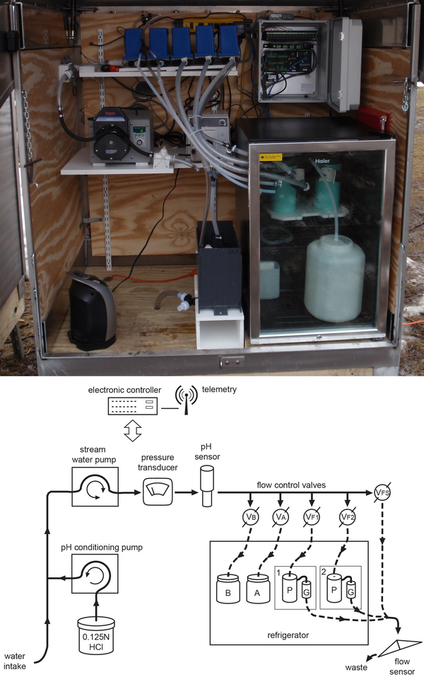
A custom automated pathogen sampler and schematic illustration.
A custom automated pathogen sampler and schematic illustration.A photograph of U.S. Geological Survey (USGS) custom automated pathogen sampler (top) and schematic illustrating the remote-unattended-automated pathogen sampler (bottom). Sample collection proceeds over the course of a runoff-event or low-flow period for up to a maximum of 5 days before a site visit by personnel is needed to collect the samples.

Buras water tank, eye of Hurricane Katrina made its strongest landfall
Buras water tank, eye of Hurricane Katrina made its strongest landfallNew Orleans, La., July 29, 2008 -- Buras has become famous as the location where, on August 29, 2005, at 6:10 AM CDT, the eye of Hurricane Katrina, made its strongest landfall. The town's freshing painted water tower stands as a symbol of recovery for the state and the community. Jacinta Quesada/FEMA
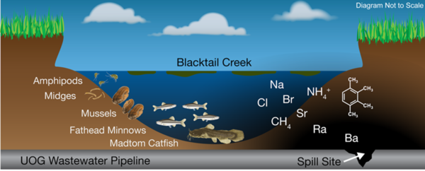
Wastewater from oil production in the Williston Basin leaked from a pipeline
Wastewater from oil production in the Williston Basin leaked from a pipelineWastewater from oil production in the Williston Basin leaked from a pipeline, spilling into Blacktail Creek, North Dakota. Geochemical and biological samples were to identify geochemical signatures of spilled wastewaters as well as biological responses.

Cumulative impacts of oil and gas production on watersheds in ND
Cumulative impacts of oil and gas production on watersheds in NDCumulative impacts of oil and gas production on watersheds in North Dakota between January 2008 and June 2015. Watershed volumes were calculated by combining reported values of oil, brine, and unidentified liquid waste accidentally released during drilling operations.

Team of scientists studied changes in nitrapyrin
A team of scientists studied changes in nitrapyrin — a nitrification inhibitor applied with fertilizers as a bactericide to kill natural soil bacteria for the purpose of increasing crop yields — occurrence associated with land use changes from March to June 2016.
A team of scientists studied changes in nitrapyrin — a nitrification inhibitor applied with fertilizers as a bactericide to kill natural soil bacteria for the purpose of increasing crop yields — occurrence associated with land use changes from March to June 2016.

Photomontage created to highlight the environment
Photomontage of multiple pictures showing environmental changes including within wildlife and urban environments
Photomontage of multiple pictures showing environmental changes including within wildlife and urban environments

Iron Reducing Bacteria
Iron Reducing Bacteria
FeRB isolated using a roll bottle technique from the former Uranium Mine near Ronneburg, Germany, Photo credit: Denise Akob, USGS
Iron Reducing Bacteria
FeRB isolated using a roll bottle technique from the former Uranium Mine near Ronneburg, Germany, Photo credit: Denise Akob, USGS

Burning coal to provide energy contributes mercury to the atmosphere
Burning coal to provide energy contributes mercury to the atmosphereBurning coal to provide energy contributes mercury to the atmosphere
Burning coal to provide energy contributes mercury to the atmosphere
Burning coal to provide energy contributes mercury to the atmosphereBurning coal to provide energy contributes mercury to the atmosphere

Raised Black External Tumors on an Adult Brown Bullhead Fish
Raised Black External Tumors on an Adult Brown Bullhead FishRaised black external tumors on adult brown bullhead (Ameiurus nebulosus) collected from Lake Memphremagog (Vermont and Canadian Border) were identified as malignant melanoma in a 2014–17 study.

A map of bladder cancer mortality rates
Bladder cancer rates have been elevated in northern New England for at least 5 decades in males and females, which suggests environmental causal factors.
Bladder cancer rates have been elevated in northern New England for at least 5 decades in males and females, which suggests environmental causal factors.

A map of Ohio showing the locations of recreational areas sampled
A map of Ohio showing the locations of recreational areas sampledA map of Ohio showing the locations of recreational areas sampled in the 201314 study. Modified from figure 1, Francy and others, 2016.
A map of Ohio showing the locations of recreational areas sampled
A map of Ohio showing the locations of recreational areas sampledA map of Ohio showing the locations of recreational areas sampled in the 201314 study. Modified from figure 1, Francy and others, 2016.

Diatom mat used during a feeding experiment to study dietary uptake
Diatom mat used during a feeding experiment to study dietary uptakeDiatom mat used during a feeding experiment to study the dietary uptake of uranium by mayflies
Diatom mat used during a feeding experiment to study dietary uptake
Diatom mat used during a feeding experiment to study dietary uptakeDiatom mat used during a feeding experiment to study the dietary uptake of uranium by mayflies

Interactive map that identifies NRDAR cases
The new Damage Assessment and Restoration Tracking System (DARTS) Web site provides an interactive map that identifies Natural Resource Damage Assessment and Restoration (NRDAR) cases. The shapes of icons represent incident type; icon color represents the status of the case.
The new Damage Assessment and Restoration Tracking System (DARTS) Web site provides an interactive map that identifies Natural Resource Damage Assessment and Restoration (NRDAR) cases. The shapes of icons represent incident type; icon color represents the status of the case.