Ground-Truthing After the M4.0 Earthquake in Southern Maine, October 16, 2012
Release Date: DECEMBER 1, 2016
Old-fashioned interviews are compared to Did You Feel It? responses for this earthquake.

On October 16, 2012, at 7:12 pm EDT an M4.0 earthquake occurred in southern Maine that was widely felt. Since moderate-size earthquakes don’t happen that often in New England, a small group of scientists spent some time afterward in the general vicinity to collect information on the earthquake effects. The data they collected provided a “ground-truth” check on the Did You Feel It? (DYFI) data that were collected through the USGS's online questionnaire following the earthquake.
The New England area is not even remotely close to a modern plate tectonic boundary, so it doesn’t experience earthquakes very often. An earthquake does happen somewhere in New England every once in a while, but it’s usually too small to associate with a specific fault. Scientists think these infrequent earthquakes are caused by modern plate stresses on old faults, but the exact mechanism is not known.
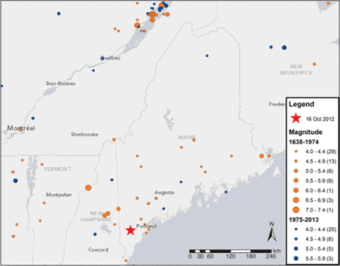
There are two named seismic zones in the region. The Charlevoix seismic zone is the most active in the northeast U.S. and is centered in the Saint Lawrence Seaway. The October 2012 M4.0 earthquake was in the northeast Massachusetts seismic zone, further to the south. The statistics for these two seismic zones indicates that on average there will be an M4.6 about every 20 years, an M5.0 about every 50 years, and an M7.0 about every 2,500 years.
The largest earthquake to occur in Maine was on March 21, 1904, before there were any accurate instruments in the area. It is estimated to have been about a magnitude 6, based on the shaking intensity data (maximum Modified Mercalli Intensity (MMI) of approximately VII). The largest instrumentally-recorded earthquake was an M4.8 on June 21, 1973, in western Maine.

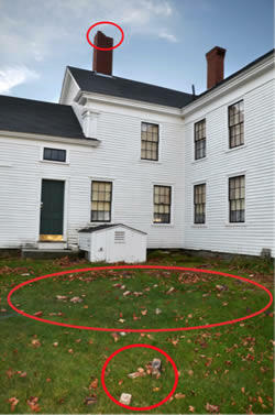
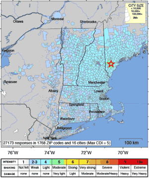
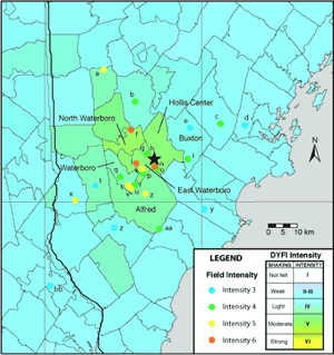
The epicenter of the October 2012 earthquake was 35 km west of Portland, Maine, near Waterboro and Hollis Center. The fault plane it occurred on was on a north-south line dipping steeply to the east. The rupture propagated from the bottom part of the fault toward the surface, and the motion on the fault was a reverse-thrust. (See also the thrust fault animation.) The only damage was a broken chimney and cracks in the plaster of two buildings in Waterboro. Interviews with 27 citizens indicated a maximum MMI of V-VI, compared with the DYFI maximum MMI of V. At 15 km from the epicenter, the MMI was about III to IV. Seismic waves travel more efficiently through the older, harder Northeastern U.S. than in the Western U.S. This M4.0 was felt as far as 400km away, but if it had occurred in California, it would have been felt only out to 75km.
The ground-truth interviews provided by residents in the Waterboro and Hollis Center areas showed that for moderate-size earthquakes with relatively few DYFI data, the DYFI method of averaging the reported shaking within a Zip Code may average out the strongest shaking. Fortunately, the DYFI data are now all geocoded and averaged at a more detailed, 1-km resolution than allowed by typical Zip Code areas. The geocoded data are an improvement especially for moderate-size events like the M4.0 earthquake in southern Maine.
-written by Lisa Wald, U.S. Geological Survey
The Scientists Behind the Science
- Jack Boatwright
- Alex Ferguson


Below are publications associated with this project.
Field survey of earthquake effects from the magnitude 4.0 southern Maine earthquake of October 16, 2012 Field survey of earthquake effects from the magnitude 4.0 southern Maine earthquake of October 16, 2012
Release Date: DECEMBER 1, 2016
Old-fashioned interviews are compared to Did You Feel It? responses for this earthquake.

On October 16, 2012, at 7:12 pm EDT an M4.0 earthquake occurred in southern Maine that was widely felt. Since moderate-size earthquakes don’t happen that often in New England, a small group of scientists spent some time afterward in the general vicinity to collect information on the earthquake effects. The data they collected provided a “ground-truth” check on the Did You Feel It? (DYFI) data that were collected through the USGS's online questionnaire following the earthquake.
The New England area is not even remotely close to a modern plate tectonic boundary, so it doesn’t experience earthquakes very often. An earthquake does happen somewhere in New England every once in a while, but it’s usually too small to associate with a specific fault. Scientists think these infrequent earthquakes are caused by modern plate stresses on old faults, but the exact mechanism is not known.
There are two named seismic zones in the region. The Charlevoix seismic zone is the most active in the northeast U.S. and is centered in the Saint Lawrence Seaway. The October 2012 M4.0 earthquake was in the northeast Massachusetts seismic zone, further to the south. The statistics for these two seismic zones indicates that on average there will be an M4.6 about every 20 years, an M5.0 about every 50 years, and an M7.0 about every 2,500 years.
The largest earthquake to occur in Maine was on March 21, 1904, before there were any accurate instruments in the area. It is estimated to have been about a magnitude 6, based on the shaking intensity data (maximum Modified Mercalli Intensity (MMI) of approximately VII). The largest instrumentally-recorded earthquake was an M4.8 on June 21, 1973, in western Maine.

The epicenter of the October 2012 earthquake was 35 km west of Portland, Maine, near Waterboro and Hollis Center. The fault plane it occurred on was on a north-south line dipping steeply to the east. The rupture propagated from the bottom part of the fault toward the surface, and the motion on the fault was a reverse-thrust. (See also the thrust fault animation.) The only damage was a broken chimney and cracks in the plaster of two buildings in Waterboro. Interviews with 27 citizens indicated a maximum MMI of V-VI, compared with the DYFI maximum MMI of V. At 15 km from the epicenter, the MMI was about III to IV. Seismic waves travel more efficiently through the older, harder Northeastern U.S. than in the Western U.S. This M4.0 was felt as far as 400km away, but if it had occurred in California, it would have been felt only out to 75km.
The ground-truth interviews provided by residents in the Waterboro and Hollis Center areas showed that for moderate-size earthquakes with relatively few DYFI data, the DYFI method of averaging the reported shaking within a Zip Code may average out the strongest shaking. Fortunately, the DYFI data are now all geocoded and averaged at a more detailed, 1-km resolution than allowed by typical Zip Code areas. The geocoded data are an improvement especially for moderate-size events like the M4.0 earthquake in southern Maine.
-written by Lisa Wald, U.S. Geological Survey
The Scientists Behind the Science
- Jack Boatwright
- Alex Ferguson


Below are publications associated with this project.

