
The USGS collects data after wildfires and following storm events to better understand debris-flow hazards and their impacts.
Postfire Data Collection
The USGS collects data at multiple stages after wildfire to better understand how burned landscapes respond to rainfall, document postfire flood and debris-flow events, and support research used to improve debris-flow hazard models.
Immediately after a fire
Monitoring stations are installed in select burned areas to help us understand the processes that control postfire debris-flow initiation and growth. These stations are installed shortly after the fire, and are designed collect data on watershed response, debris-flow timing, and rainfall characteristics during storms that trigger debris flows.
Following an event
After postfire flooding or debris-flow events, the USGS works closely with partners to document what happened, where impacts occurred, how much rain fell, and what costs or damages were associated the event. This information may be supplemented by data from monitoring stations, satellite imagery and other remote sensing, and media reports.
Long-term monitoring
Long-term monitoring helps the USGS understand the frequency and magnitude of shallow landslides as burned watersheds recover.
Postfire Flooding and Debris Flow Events
2024 Elk Fire Postfire Flooding and Debris Flows
2021 Dixie Fire Postfire Debris Flows: A Tale of Two Storms
2020 Cameron Peak Fire, Colorado: Flooding and Debris Flows
2020 Grizzly Creek Fire, Colorado: Flooding and Debris Flows
Recent Postfire Monitoring Stations
Monitoring station locations are selected based on watershed characteristics and burn severity and typically include rain gauges, cameras, and subsurface equipment that collect information on soil and other subsurface properties.
-

Postfire Landslide Monitoring Station: “Maria Ygnacio” (2019 Cave Fire) near Santa Barbara, California
Wildfire can increase landslide susceptibility in mountainous terrain. The USGS maintains postfire landslide monitoring stations to track hillslope hydrologic conditions in the years following fire.
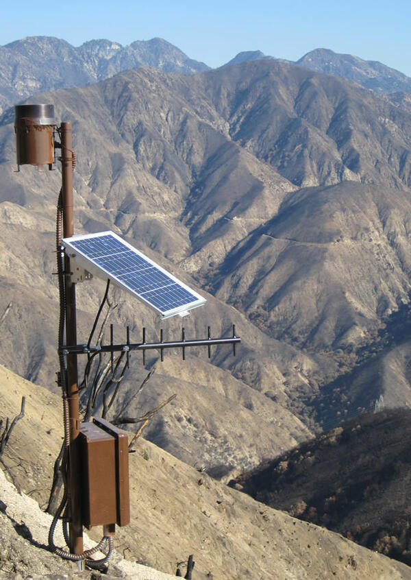
Postfire Landslide Monitoring Station: “Las Lomas” (2016 Fish Fire) near Duarte, California
Wildfire can increase landslide susceptibility in mountainous terrain. The USGS maintains postfire landslide monitoring stations to track hillslope hydrologic conditions in the years following fire.
-
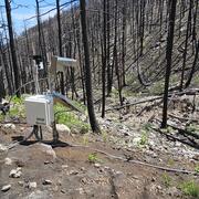
Elk Postfire Monitoring Station near Dayton, Wyoming
Wildfire can radically change a mountainous landscape such that even a modest rainstorm can produce deadly and destructive flash flooding and debris flows.
Debris Flows in Action
The videos below were captured by USGS cameras installed in recently burned areas. Cameras begin recording when the station rain gauge measures a specified amount of rainfall.
2024 Elk Fire, Wyoming
2021 Hermits Peak-Calf Canyon Fire, New Mexico
2016 Fish Fire, California
The USGS collects data after wildfires and following storm events to better understand debris-flow hazards and their impacts.
Postfire Data Collection
The USGS collects data at multiple stages after wildfire to better understand how burned landscapes respond to rainfall, document postfire flood and debris-flow events, and support research used to improve debris-flow hazard models.
Immediately after a fire
Monitoring stations are installed in select burned areas to help us understand the processes that control postfire debris-flow initiation and growth. These stations are installed shortly after the fire, and are designed collect data on watershed response, debris-flow timing, and rainfall characteristics during storms that trigger debris flows.
Following an event
After postfire flooding or debris-flow events, the USGS works closely with partners to document what happened, where impacts occurred, how much rain fell, and what costs or damages were associated the event. This information may be supplemented by data from monitoring stations, satellite imagery and other remote sensing, and media reports.
Long-term monitoring
Long-term monitoring helps the USGS understand the frequency and magnitude of shallow landslides as burned watersheds recover.
Postfire Flooding and Debris Flow Events
2024 Elk Fire Postfire Flooding and Debris Flows
2021 Dixie Fire Postfire Debris Flows: A Tale of Two Storms
2020 Cameron Peak Fire, Colorado: Flooding and Debris Flows
2020 Grizzly Creek Fire, Colorado: Flooding and Debris Flows
Recent Postfire Monitoring Stations
Monitoring station locations are selected based on watershed characteristics and burn severity and typically include rain gauges, cameras, and subsurface equipment that collect information on soil and other subsurface properties.
-
-
Postfire Landslide Monitoring Station: “Maria Ygnacio” (2019 Cave Fire) near Santa Barbara, California
Wildfire can increase landslide susceptibility in mountainous terrain. The USGS maintains postfire landslide monitoring stations to track hillslope hydrologic conditions in the years following fire. -
Postfire Landslide Monitoring Station: “Las Lomas” (2016 Fish Fire) near Duarte, California
Wildfire can increase landslide susceptibility in mountainous terrain. The USGS maintains postfire landslide monitoring stations to track hillslope hydrologic conditions in the years following fire.
-
-
Elk Postfire Monitoring Station near Dayton, Wyoming
Wildfire can radically change a mountainous landscape such that even a modest rainstorm can produce deadly and destructive flash flooding and debris flows.
Debris Flows in Action
The videos below were captured by USGS cameras installed in recently burned areas. Cameras begin recording when the station rain gauge measures a specified amount of rainfall.