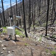
Timelapse photography of vegetation recovery following the 2020 CZU Lightning Complex in the Santa Cruz Mountains of northern California. This two-year image sequence begins four and a half months after the wildfire was contained. Time between photographs is approximately two weeks.
Matthew A Thomas
Matt Thomas is a research hydrologist in the Landslide Hazards Program.
I am a quantitative geoscientist excited to work on societally relevant earth science and engineering problems. My research at the USGS contributes to rainfall-induced landslide and post-fire debris-flow hazard warning products designed to reduce loss of life and property.
Professional Experience
2022 – Research Hydrologist, U.S. Geological Survey, Golden, CO
2017 – 2021 Mendenhall Postdoctoral Fellow, U.S. Geological Survey, Golden, CO
2015 – 2017 R&D Geosciences Engineer, Sandia National Laboratories, Carlsbad, NM
2014 – 2015 Postdoctoral Scholar, Stanford University, Stanford, CA
2009 – 2014 Graduate Student Researcher, Stanford University, Stanford, CA
2008 – 2009 Staff Geologist, Cornerstone Earth Group, Sunnyvale, CA
Education and Certifications
2014 PhD in Hydrogeology, Stanford University
2014 MS in Civil and Environmental Engineering, Stanford University
2008 BS in Geology, University of California Los Angeles
Science and Products
Landslide Hazards Seminar
Postfire Landslide Monitoring Station: “Las Lomas” (2016 Fish Fire) near Duarte, California
Postfire Landslide Monitoring Station: “Maria Ygnacio” (2019 Cave Fire) near Santa Barbara, California
Dixie Fire Post-Fire Debris Flows: A Tale of Two Storms
Calwood Fire "Heil Ranch" Landslide Monitoring Site near Boulder, CO
Postfire Landslide Monitoring Station: "Chips" (2021 Dixie Fire) near Belden, CA
Postfire Landslide Monitoring Station: "Chambers" (2021 Dixie Fire) near Belden, CA
Rainfall, Video, and Geophone Data from the Hermit's Peak/ Calf Canyon Fire Burn Area, New Mexico, June 2022 to June 2024
Rainfall, Volumetric soil-water content, Video, and Geophone Data from the Calwood Fire Burn Area, Colorado, April 2021 to November 2023
International compilation of peak discharge estimates of floods and runoff-generated debris flows, 1931-2023
Field observations of landslides and related materials following Hurricane Maria, Puerto Rico
Field-verified inventory of postfire hydrologic response for the 2020 CZU Lightning Complex, River, Camel, and Dolan Fires following a 26-29 January 2021 atmospheric river storm sequence
Field-verified inventory of postfire debris flows for the 2021 Dixie Fire following a 23-25 October 2021 atmospheric river storm and 12 June 2022 thunderstorm
Soil moisture monitoring following the 2009 Station Fire, California, USA, 2016-2019
Hillslope hydrologic monitoring data following Hurricane Maria in 2017, Puerto Rico, July 2018 to June 2020
Infiltration data collected post-Hurricane Maria across landslide source area materials, Puerto Rico, USA
Field data used to support hydrologic modeling for the U.S. Geological Survey's San Francisco Bay Area "BALT1" landslide monitoring site
Timelapse photography of vegetation recovery following the 2020 CZU Lightning Complex in the Santa Cruz Mountains of northern California. This two-year image sequence begins four and a half months after the wildfire was contained. Time between photographs is approximately two weeks.
The granitic cliffs of Yosemite Valley produce frequent rockfalls, modifying the landscape but also posing risk to park visitors. Analyses of terrestrial lidar and historical structure-from-motion photogrammetry data provide relatively precise short-term (approximately 40 years) rates of rockfall and cliff retreat.
Understanding of rockfall frequency-magnitude relationships is important for managing rockfall hazards, but characterizing these relationships is a challenging problem due to limited data, limited access, and the difficulty of accurately dating historic rockfalls.
The 92-mile, dead-end Denali Park Road crosses an accelerating rock glacier. Until 2014, the rock glacier would only displace the road a few tens of centimeters per year, however during the summer of 2021 the rock glacier has moved the road almost 40 cm/day.
Three soil moisture sensors shown before their installation in a soil pit. The sensors will form a vertical subsurface array geared to track infiltration behavior.
Soil pit shown with three soil moisture sensors installed in a subsurface vertical array. The wetting and drying of the soil will be tracked over multi-annual timescales.
Soil moisture sensor prior to installation in the 2020 Calwood Fire burn area, Boulder County, Colorado
linkA soil moisture sensor shown prior to installation in a soil pit. This kind of sensor measures the dielectric constant of the soil using capacitance and frequency domain technology.
Soil moisture sensor prior to installation in the 2020 Calwood Fire burn area, Boulder County, Colorado
linkA soil moisture sensor shown prior to installation in a soil pit. This kind of sensor measures the dielectric constant of the soil using capacitance and frequency domain technology.
Hillslopes in the 2020 Calwood Fire burn area covered by burned and partially burned trees. This photo was taken approximately 6 months after the fire.
This photograph of a small watershed within the 2020 Calwood Fire burn area, Boulder County, Colorado was taken 6 months following the fire. The removal of vegetation and change in soil properties make steeply burned areas susceptible to postfire debris flows.
Scientists installed a hillslope monitoring station following the 2020 Calwood Fire, Boulder County, Colorado. These monitoring stations help to collect data, such rainfall and soil moisture, that is used to better understand postfire debris-flow processes.
A robust quantitative method to distinguish runoff-generated debris flows from floods
Evaluating post-wildfire debris-flow rainfall thresholds and volume models at the 2020 Grizzly Creek Fire in Glenwood Canyon, Colorado, USA
Rainfall intensification amplifies exposure of American Southwest to conditions that trigger postfire debris flows
How long do runoff-generated debris-flow hazards persist after wildfire?
The spatial distribution of debris flows in relation to observed rainfall anomalies: Insights from the Dolan Fire, California
Postfire hydrologic response along the central California (USA) coast: Insights for the emergency assessment of postfire debris-flow hazards
The rainfall intensity-duration control of debris flows after wildfire
Postwildfire soil‐hydraulic recovery and the persistence of debris flow hazards
Hillslopes in humid-tropical climates aren’t always wet: Implications for hydrologic response and landslide initiation in Puerto Rico, USA
Deep Learning as a tool to forecast hydrologic response for landslide-prone hillslopes
Geometric and material variability influences stress states relevant to coastal permafrost bluff failure
Assessing the feasibility of satellite-based thresholds for hydrologically driven landsliding
Non-USGS Publications**
**Disclaimer: The views expressed in Non-USGS publications are those of the author and do not represent the views of the USGS, Department of the Interior, or the U.S. Government.
Dixie Fire Post-Fire Debris Flows: A Tale of Two Storms
Science and Products
Landslide Hazards Seminar
Postfire Landslide Monitoring Station: “Las Lomas” (2016 Fish Fire) near Duarte, California
Postfire Landslide Monitoring Station: “Maria Ygnacio” (2019 Cave Fire) near Santa Barbara, California
Dixie Fire Post-Fire Debris Flows: A Tale of Two Storms
Calwood Fire "Heil Ranch" Landslide Monitoring Site near Boulder, CO
Postfire Landslide Monitoring Station: "Chips" (2021 Dixie Fire) near Belden, CA
Postfire Landslide Monitoring Station: "Chambers" (2021 Dixie Fire) near Belden, CA
Rainfall, Video, and Geophone Data from the Hermit's Peak/ Calf Canyon Fire Burn Area, New Mexico, June 2022 to June 2024
Rainfall, Volumetric soil-water content, Video, and Geophone Data from the Calwood Fire Burn Area, Colorado, April 2021 to November 2023
International compilation of peak discharge estimates of floods and runoff-generated debris flows, 1931-2023
Field observations of landslides and related materials following Hurricane Maria, Puerto Rico
Field-verified inventory of postfire hydrologic response for the 2020 CZU Lightning Complex, River, Camel, and Dolan Fires following a 26-29 January 2021 atmospheric river storm sequence
Field-verified inventory of postfire debris flows for the 2021 Dixie Fire following a 23-25 October 2021 atmospheric river storm and 12 June 2022 thunderstorm
Soil moisture monitoring following the 2009 Station Fire, California, USA, 2016-2019
Hillslope hydrologic monitoring data following Hurricane Maria in 2017, Puerto Rico, July 2018 to June 2020
Infiltration data collected post-Hurricane Maria across landslide source area materials, Puerto Rico, USA
Field data used to support hydrologic modeling for the U.S. Geological Survey's San Francisco Bay Area "BALT1" landslide monitoring site
Timelapse photography of vegetation recovery following the 2020 CZU Lightning Complex in the Santa Cruz Mountains of northern California. This two-year image sequence begins four and a half months after the wildfire was contained. Time between photographs is approximately two weeks.
The granitic cliffs of Yosemite Valley produce frequent rockfalls, modifying the landscape but also posing risk to park visitors. Analyses of terrestrial lidar and historical structure-from-motion photogrammetry data provide relatively precise short-term (approximately 40 years) rates of rockfall and cliff retreat.
Understanding of rockfall frequency-magnitude relationships is important for managing rockfall hazards, but characterizing these relationships is a challenging problem due to limited data, limited access, and the difficulty of accurately dating historic rockfalls.
The 92-mile, dead-end Denali Park Road crosses an accelerating rock glacier. Until 2014, the rock glacier would only displace the road a few tens of centimeters per year, however during the summer of 2021 the rock glacier has moved the road almost 40 cm/day.
Three soil moisture sensors shown before their installation in a soil pit. The sensors will form a vertical subsurface array geared to track infiltration behavior.
Soil pit shown with three soil moisture sensors installed in a subsurface vertical array. The wetting and drying of the soil will be tracked over multi-annual timescales.
Soil moisture sensor prior to installation in the 2020 Calwood Fire burn area, Boulder County, Colorado
linkA soil moisture sensor shown prior to installation in a soil pit. This kind of sensor measures the dielectric constant of the soil using capacitance and frequency domain technology.
Soil moisture sensor prior to installation in the 2020 Calwood Fire burn area, Boulder County, Colorado
linkA soil moisture sensor shown prior to installation in a soil pit. This kind of sensor measures the dielectric constant of the soil using capacitance and frequency domain technology.
Hillslopes in the 2020 Calwood Fire burn area covered by burned and partially burned trees. This photo was taken approximately 6 months after the fire.
This photograph of a small watershed within the 2020 Calwood Fire burn area, Boulder County, Colorado was taken 6 months following the fire. The removal of vegetation and change in soil properties make steeply burned areas susceptible to postfire debris flows.
Scientists installed a hillslope monitoring station following the 2020 Calwood Fire, Boulder County, Colorado. These monitoring stations help to collect data, such rainfall and soil moisture, that is used to better understand postfire debris-flow processes.
A robust quantitative method to distinguish runoff-generated debris flows from floods
Evaluating post-wildfire debris-flow rainfall thresholds and volume models at the 2020 Grizzly Creek Fire in Glenwood Canyon, Colorado, USA
Rainfall intensification amplifies exposure of American Southwest to conditions that trigger postfire debris flows
How long do runoff-generated debris-flow hazards persist after wildfire?
The spatial distribution of debris flows in relation to observed rainfall anomalies: Insights from the Dolan Fire, California
Postfire hydrologic response along the central California (USA) coast: Insights for the emergency assessment of postfire debris-flow hazards
The rainfall intensity-duration control of debris flows after wildfire
Postwildfire soil‐hydraulic recovery and the persistence of debris flow hazards
Hillslopes in humid-tropical climates aren’t always wet: Implications for hydrologic response and landslide initiation in Puerto Rico, USA
Deep Learning as a tool to forecast hydrologic response for landslide-prone hillslopes
Geometric and material variability influences stress states relevant to coastal permafrost bluff failure
Assessing the feasibility of satellite-based thresholds for hydrologically driven landsliding
Non-USGS Publications**
**Disclaimer: The views expressed in Non-USGS publications are those of the author and do not represent the views of the USGS, Department of the Interior, or the U.S. Government.