
Ongoing research efforts focus on the platform evaluation, sensor integration, technique development and data assessment activities needed to support the USGS’s and the DOI’s strategic implementation of UAS.
Platform Evaluation
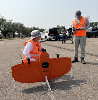
NUSO scientists are responsible for the evaluation, testing, and operational integration activities needed to incorporate new platforms into the existing DOI UAS Fleet. The NUSO works with the DOI’s Office of Aviation Services (OAS), which is responsible for aviation safety as well as management of the DOI UAS Fleet, to help identify the types of new platforms that might best suit the needs of DOI scientists.
Sensor Integration
Researchers at NUSO are responsible for the evaluation of new UAS-compatible sensors and the performance of any integration activities needed to fully utilize them during data collection missions tailored to meet DOI scientists’ needs.
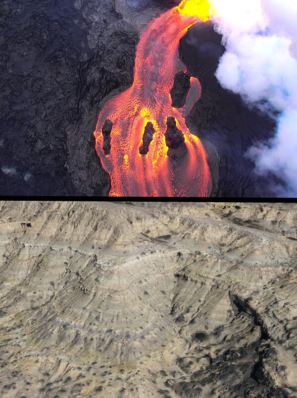
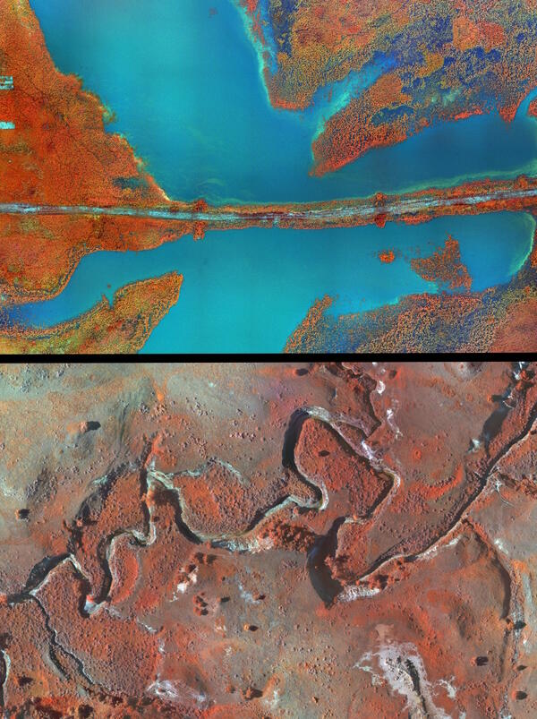
High-resolution UAS-compatible sensors offer incredible enhancement opportunities not only in the types of data that are collected but also relative to the amount, resolution, persistence, and analytics that can be applied to the data. Newer UAS-compatible sensors are often interchangeable in the field which allows for the collection of high-resolution natural color, thermal, multispectral, lidar, and other types of data over the same area at approximately the same time.
Technique Development
Another research focus at the NUSO is development of new processing techniques that utilize higher-resolution data acquired from UAS to generate geospatial products with the centimeter-level accuracies needed to best support DOI scientific research.
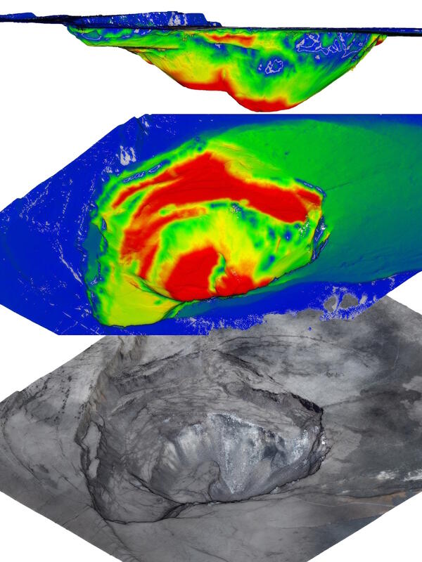
The raw overlapping imagery captured by UAS-compatible sensors can be converted into high-resolution distortion-free aerial photographs (i.e., orthophotos) using an orthorectification process. The orthorectification technique developed for UAS imagery utilizes photogrammetry software and precise GNSS data acquired during the flight to produce orthophotos that can have ground sample distances of less than 5 centimeters. Combining a series of these high-resolution orthophotos generates a seamless orthomosaic, a common base-map for geospatial analysis.
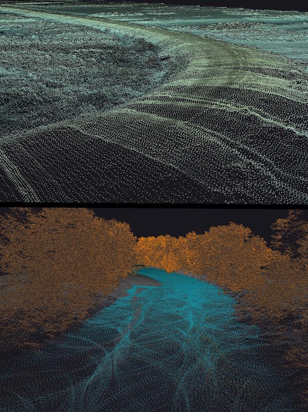
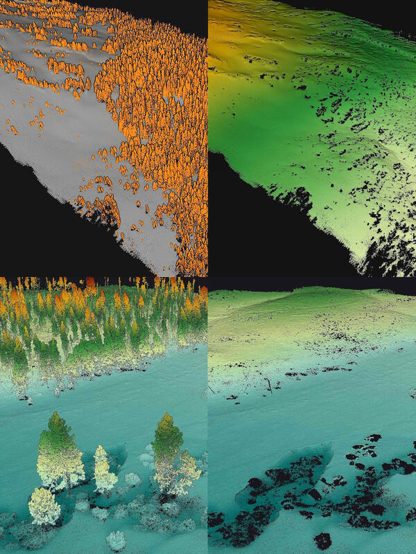
Overlapping imagery collected from various UAS-mounted sensors can also be combined with surveyed ground control points (GCPs) and processed using photogrammetry software to produce other high-resolution products including 3D point clouds and digital elevation models.
Radiometric calibration capabilities are being strengthened to support UAS-derived image calibration and best-practices for scientific analysis. Radiometric calibration, the process of converting image pixels to meaningful physical units such as reflectance, is a critical step when utilizing UAS-collected imagery for scientific research. Radiometric calibration efforts include investigating various calibration target options, such as tarps and rigid panels, for optimal performance and practicality in the field, documenting the protocols for collecting ground-truth spectral measurements using multiple types of spectroradiometer instruments, and directing DOI scientists to relevant radiometric calibration references and resources.
Data Assessment
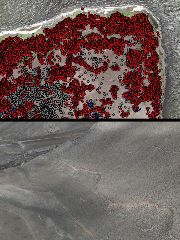
Development of the best-practices and data standards needed to achieve high-quality UAS-derived spectral and structural geospatial data products is another focus of research at the NUSO. Evaluation of the high-resolution and low-altitude data acquired from UAS-mounted sensors is being used to establish recommendations for data collection, data processing, and ground control referencing to aid accuracy assessment and verification. Quality assurance and quality control efforts are being validated for UAS-acquired lidar by combining UAS-collected data with a Global Navigation Survey System (GNSS) survey quality base station, ground control targets, and vertical GPS lidar reflector points for three-dimensional ground control and vertical height assessments. Protocols are being developed for collecting ground-truth spectral measurements using field-based portable spectroradiometers. Accuracy assessments are also taking place on a wide range of lower-cost spectrometers. NUSO and collaborators are working to understand and quantify the levels of spectral data accuracy that can be achieved using commercial off-the-shelf spectral cameras.
Data standards are written and updated as new UAS compatible sensors are tested and verified. For example, the YellowScan VX-20 lidar scanner lists a 1 cm level of precision (at one standard deviation) and 2.5 cm of network accuracy; these specifications are then validated with either data acquired during actual flights or based on unique stand-alone tests. Once verified, these specifications can be used to generate the metadata associated with USGS UAS published data releases.
As newer GNSS receivers are being marketed, NUSO is analyzing their GNSS survey data to outline their strengths and limitations in support of UAS data validation. Various GNSS correction methods are also being evaluated based on specific technological advancements including NOAA’s Online Positioning User Service (OPUS), Trimble RTX, Propeller AeroPoints Correction Network, MakeItAccurate.com, and NASA JPL GispyX.
Performance of research missions, often in cooperation with other DOI bureaus and federal collaborators, is a vital tool for the success of these research efforts to establish UAS's effectiveness for specific earth science investigations.
Ongoing research efforts focus on the platform evaluation, sensor integration, technique development and data assessment activities needed to support the USGS’s and the DOI’s strategic implementation of UAS.
Platform Evaluation
NUSO scientists are responsible for the evaluation, testing, and operational integration activities needed to incorporate new platforms into the existing DOI UAS Fleet. The NUSO works with the DOI’s Office of Aviation Services (OAS), which is responsible for aviation safety as well as management of the DOI UAS Fleet, to help identify the types of new platforms that might best suit the needs of DOI scientists.
Sensor Integration
Researchers at NUSO are responsible for the evaluation of new UAS-compatible sensors and the performance of any integration activities needed to fully utilize them during data collection missions tailored to meet DOI scientists’ needs.
High-resolution UAS-compatible sensors offer incredible enhancement opportunities not only in the types of data that are collected but also relative to the amount, resolution, persistence, and analytics that can be applied to the data. Newer UAS-compatible sensors are often interchangeable in the field which allows for the collection of high-resolution natural color, thermal, multispectral, lidar, and other types of data over the same area at approximately the same time.
Technique Development
Another research focus at the NUSO is development of new processing techniques that utilize higher-resolution data acquired from UAS to generate geospatial products with the centimeter-level accuracies needed to best support DOI scientific research.
The raw overlapping imagery captured by UAS-compatible sensors can be converted into high-resolution distortion-free aerial photographs (i.e., orthophotos) using an orthorectification process. The orthorectification technique developed for UAS imagery utilizes photogrammetry software and precise GNSS data acquired during the flight to produce orthophotos that can have ground sample distances of less than 5 centimeters. Combining a series of these high-resolution orthophotos generates a seamless orthomosaic, a common base-map for geospatial analysis.
Overlapping imagery collected from various UAS-mounted sensors can also be combined with surveyed ground control points (GCPs) and processed using photogrammetry software to produce other high-resolution products including 3D point clouds and digital elevation models.
Radiometric calibration capabilities are being strengthened to support UAS-derived image calibration and best-practices for scientific analysis. Radiometric calibration, the process of converting image pixels to meaningful physical units such as reflectance, is a critical step when utilizing UAS-collected imagery for scientific research. Radiometric calibration efforts include investigating various calibration target options, such as tarps and rigid panels, for optimal performance and practicality in the field, documenting the protocols for collecting ground-truth spectral measurements using multiple types of spectroradiometer instruments, and directing DOI scientists to relevant radiometric calibration references and resources.
Data Assessment
Development of the best-practices and data standards needed to achieve high-quality UAS-derived spectral and structural geospatial data products is another focus of research at the NUSO. Evaluation of the high-resolution and low-altitude data acquired from UAS-mounted sensors is being used to establish recommendations for data collection, data processing, and ground control referencing to aid accuracy assessment and verification. Quality assurance and quality control efforts are being validated for UAS-acquired lidar by combining UAS-collected data with a Global Navigation Survey System (GNSS) survey quality base station, ground control targets, and vertical GPS lidar reflector points for three-dimensional ground control and vertical height assessments. Protocols are being developed for collecting ground-truth spectral measurements using field-based portable spectroradiometers. Accuracy assessments are also taking place on a wide range of lower-cost spectrometers. NUSO and collaborators are working to understand and quantify the levels of spectral data accuracy that can be achieved using commercial off-the-shelf spectral cameras.
Data standards are written and updated as new UAS compatible sensors are tested and verified. For example, the YellowScan VX-20 lidar scanner lists a 1 cm level of precision (at one standard deviation) and 2.5 cm of network accuracy; these specifications are then validated with either data acquired during actual flights or based on unique stand-alone tests. Once verified, these specifications can be used to generate the metadata associated with USGS UAS published data releases.
As newer GNSS receivers are being marketed, NUSO is analyzing their GNSS survey data to outline their strengths and limitations in support of UAS data validation. Various GNSS correction methods are also being evaluated based on specific technological advancements including NOAA’s Online Positioning User Service (OPUS), Trimble RTX, Propeller AeroPoints Correction Network, MakeItAccurate.com, and NASA JPL GispyX.
Performance of research missions, often in cooperation with other DOI bureaus and federal collaborators, is a vital tool for the success of these research efforts to establish UAS's effectiveness for specific earth science investigations.