
As air flows over and around objects in its path, spiraling eddies, known as Von Karman vortices, may form. The vortices in this image were created when prevailing winds sweeping east across the northern Pacific Ocean encountered Alaska's Aleutian Islands.
Images
Browse images from a wide range of science topics covered by USGS.
Filter Total Items: 985

Von Karman Vortices
As air flows over and around objects in its path, spiraling eddies, known as Von Karman vortices, may form. The vortices in this image were created when prevailing winds sweeping east across the northern Pacific Ocean encountered Alaska's Aleutian Islands.

Alaska Mountain Range
Alaska mountain range.

Alaska Mountain Range
Alaska mountain range.

Alaska Scenic View
Scenic view of Alaskan lake and mountains.
Scenic view of Alaskan lake and mountains.

Kamchatka Peninsula
The eastern side of Russia's Kamchatka Peninsula juts into the Pacific Ocean west of Alaska. In this winter image, a volcanic terrain is hidden under snow-covered peaks and valley glaciers feed blue ice into coastal waters.
The eastern side of Russia's Kamchatka Peninsula juts into the Pacific Ocean west of Alaska. In this winter image, a volcanic terrain is hidden under snow-covered peaks and valley glaciers feed blue ice into coastal waters.

Fortress Mountain Formation, Brooks Range
View southward from Fortress Mountain Formation on Atigun syncline towards Brooks Range. Trans-Alaska Pipeline, haul road, and Galbraith Lake in valley. Location in Brooks Range foothills, about 90 miles southeast of Umiat.
View southward from Fortress Mountain Formation on Atigun syncline towards Brooks Range. Trans-Alaska Pipeline, haul road, and Galbraith Lake in valley. Location in Brooks Range foothills, about 90 miles southeast of Umiat.

Polar bear mother and two cubs on the Beaufort Sea ice
Polar bear mother and two cubs on the Beaufort Sea icePolar bear mother and two cubs on the Beaufort Sea ice.
Polar bear mother and two cubs on the Beaufort Sea ice
Polar bear mother and two cubs on the Beaufort Sea icePolar bear mother and two cubs on the Beaufort Sea ice.

Malaspina Glacier
The tongue of the Malaspina Glacier, the largest glacier in Alaska, fills most of this image. The Malaspina lies west of Yakutat Bay and covers 1,500 sq mi (3,880 sq km).
The tongue of the Malaspina Glacier, the largest glacier in Alaska, fills most of this image. The Malaspina lies west of Yakutat Bay and covers 1,500 sq mi (3,880 sq km).

Aleutian Clouds
These cloud formations were seen over the western Aleutian Islands. Their color variations are probably due to differences in temperature and in the size of water droplets that make up the clouds.
These cloud formations were seen over the western Aleutian Islands. Their color variations are probably due to differences in temperature and in the size of water droplets that make up the clouds.

John Wild River, near Anaktuvuk
Looking upstream from mid channel of the John Wild River. Near Anaktuvuk, Alaska.
Looking upstream from mid channel of the John Wild River. Near Anaktuvuk, Alaska.


Yukon Delta
An intricate maze of small lakes and waterways define the Yukon Delta at the confluence of Alaska's Yukon and Kuskokwim Rivers with the frigid Bering Sea. Wildlife abounds on the delta and offshore where sheets of sea ice form during the coldest months of the year.
An intricate maze of small lakes and waterways define the Yukon Delta at the confluence of Alaska's Yukon and Kuskokwim Rivers with the frigid Bering Sea. Wildlife abounds on the delta and offshore where sheets of sea ice form during the coldest months of the year.

Valley of Ten Thousand Smokes, Alaska
View southeast from Overlook Cabin looking over the Valley of Ten Thousand Smokes. The pyroclastic and ash deposits that fill the valley remain nearly vegetation-free more than 100 years after the 1912 Novarupta-Katmai eruption.
View southeast from Overlook Cabin looking over the Valley of Ten Thousand Smokes. The pyroclastic and ash deposits that fill the valley remain nearly vegetation-free more than 100 years after the 1912 Novarupta-Katmai eruption.
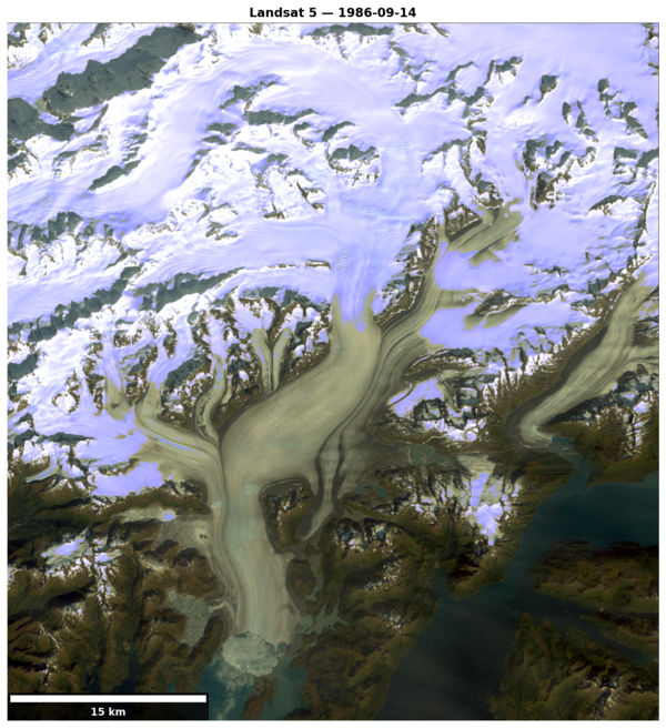
Columbia Glacier 1986
Landsat 5 image of Columbia Glacier, Alaska on Sept. 14, 1986.
Landsat 5 image of Columbia Glacier, Alaska on Sept. 14, 1986.

Tule white-fronted goose in the Kahiltna Valley, Alaska, in 1984
Tule white-fronted goose in the Kahiltna Valley, Alaska, in 1984Tule white-fronted goose in the Kahiltna Valley, Alaska, in 1984.
Tule white-fronted goose in the Kahiltna Valley, Alaska, in 1984
Tule white-fronted goose in the Kahiltna Valley, Alaska, in 1984Tule white-fronted goose in the Kahiltna Valley, Alaska, in 1984.

Repeat oblique photographs of Gulkana glaciers in Alaska.
Repeat oblique photographs of Gulkana glaciers in Alaska.Repeat oblique photographs of Gulkana glaciers in Alaska. 1967, Unknown USGS photographer. 2016, L. Sass, USGS.
Repeat oblique photographs of Gulkana glaciers in Alaska.
Repeat oblique photographs of Gulkana glaciers in Alaska.Repeat oblique photographs of Gulkana glaciers in Alaska. 1967, Unknown USGS photographer. 2016, L. Sass, USGS.
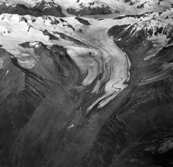
Gulkana Glacier 1967
Gulkana Glacier. Ice flowing from four tributaries unites to form the main glacier. Irregular and folded medial moraines suggest that this glacier surges, but no recent advances have been observed. In recent decades the glacier has been shrinking rapidly; note the large barren area in front of the terminus recently exposed by the melting ice.
Gulkana Glacier. Ice flowing from four tributaries unites to form the main glacier. Irregular and folded medial moraines suggest that this glacier surges, but no recent advances have been observed. In recent decades the glacier has been shrinking rapidly; note the large barren area in front of the terminus recently exposed by the melting ice.

Repeat oblique photographs of Wolverine glacier in Alaska.
Repeat oblique photographs of Wolverine glacier in Alaska.Repeat oblique photographs of Wolverine glacier in Alaska. 1966 image by unknown USGS photographer; 2015 image by L. Sass, USGS.
Repeat oblique photographs of Wolverine glacier in Alaska.
Repeat oblique photographs of Wolverine glacier in Alaska.Repeat oblique photographs of Wolverine glacier in Alaska. 1966 image by unknown USGS photographer; 2015 image by L. Sass, USGS.
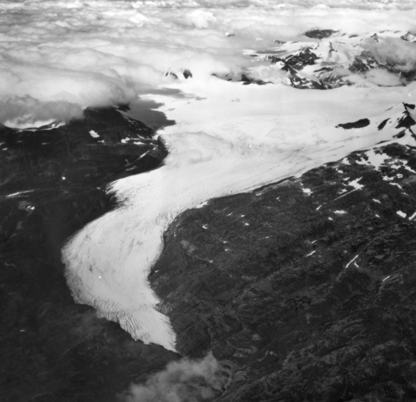
Wolverine Glacier 1966
Wolverine Glacier. The glacier heads in a broad basin but terminates in a narrow gorge. Crevasses indicate this glacier is flowing quite rapidly. Relatively little retreat in recent decades is demonstrated by the narrow areas of recently exposed bedrock along the margins of the ice. Seward district, Alaska Gulf region, Alaska. September 3, 1966.
Wolverine Glacier. The glacier heads in a broad basin but terminates in a narrow gorge. Crevasses indicate this glacier is flowing quite rapidly. Relatively little retreat in recent decades is demonstrated by the narrow areas of recently exposed bedrock along the margins of the ice. Seward district, Alaska Gulf region, Alaska. September 3, 1966.

Chenega Village after tsunami waves hit in 1964
Photograph taken in 1964 of the main part of the Chenega village site in Alaska. Pilings in the ground mark the former locations of homes swept away by tsunami waves. The schoolhouse on high ground was undamaged.
Photograph taken in 1964 of the main part of the Chenega village site in Alaska. Pilings in the ground mark the former locations of homes swept away by tsunami waves. The schoolhouse on high ground was undamaged.
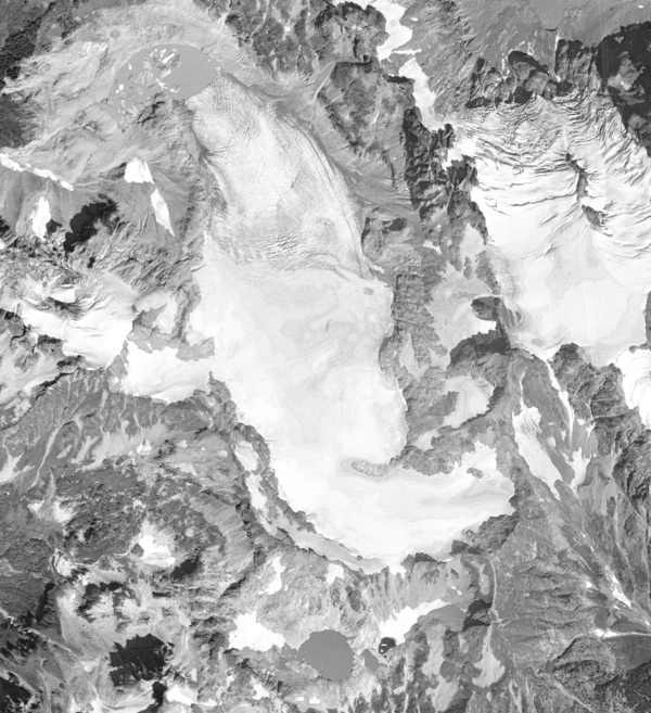
South Cascade Glacier August 13th, 1958
Aerial photograph of South Cascade Glacier, WA taken August 13th, 1958.
Aerial photograph of South Cascade Glacier, WA taken August 13th, 1958.