
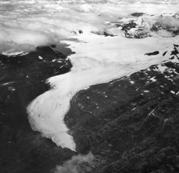
Wolverine Glacier. The glacier heads in a broad basin but terminates in a narrow gorge. Crevasses indicate this glacier is flowing quite rapidly. Relatively little retreat in recent decades is demonstrated by the narrow areas of recently exposed bedrock along the margins of the ice. Seward district, Alaska Gulf region, Alaska. September 3, 1966.
Images
Browse images from a wide range of science topics covered by USGS.
Filter Total Items: 988
Wolverine Glacier 1966
Wolverine Glacier. The glacier heads in a broad basin but terminates in a narrow gorge. Crevasses indicate this glacier is flowing quite rapidly. Relatively little retreat in recent decades is demonstrated by the narrow areas of recently exposed bedrock along the margins of the ice. Seward district, Alaska Gulf region, Alaska. September 3, 1966.

Chenega Village after tsunami waves hit in 1964
Photograph taken in 1964 of the main part of the Chenega village site in Alaska. Pilings in the ground mark the former locations of homes swept away by tsunami waves. The schoolhouse on high ground was undamaged.
Photograph taken in 1964 of the main part of the Chenega village site in Alaska. Pilings in the ground mark the former locations of homes swept away by tsunami waves. The schoolhouse on high ground was undamaged.
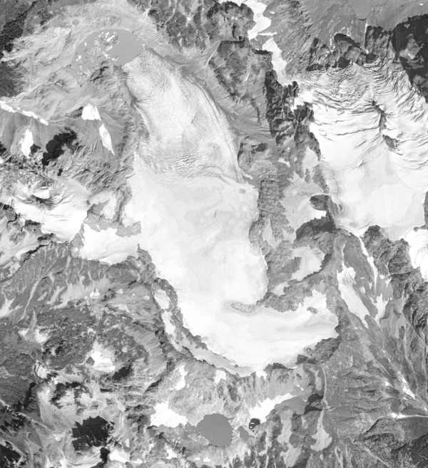
South Cascade Glacier August 13th, 1958
Aerial photograph of South Cascade Glacier, WA taken August 13th, 1958.
Aerial photograph of South Cascade Glacier, WA taken August 13th, 1958.

Muir and Riggs Glaciers, Muir Inlet, Alaska - 1950
Muir and Riggs Glaciers, Muir Inlet, Alaska - 1950This, the first of two repeat photographs, documents significant changes that have occurred during the nine years between photographs A and B. Although Muir Glacier has retreated more than 3 kilometers and thinned more than 100 meters, exposing Muir Inlet, it remains connected with tributary Riggs Glacier. White Thunder Ridge remains devoid of vegetation.

Muir and Riggs Glaciers, Muir Inlet, Alaska - 1941
Muir and Riggs Glaciers, Muir Inlet, Alaska - 1941This northeast-looking photograph, on the southeastern side of White Thunder Ridge ,shows the lower reaches of Muir Glacier, then a large tidewater calving valley glacier, and its tributary Riggs Glacier. The séracs in the lower right-hand corner of the photograph mark Muir Glacier’s terminus. The ice thickness is more than 700 meters.

Katmai National Park and Preserve, Alaska
Volcanic ash drifts around houses at Katmai after the June 1912 eruption of Novarupta Volcano. Church in the distant background. August 13, 1912.
Volcanic ash drifts around houses at Katmai after the June 1912 eruption of Novarupta Volcano. Church in the distant background. August 13, 1912.

Geologic Studies on Sitkinak Island, Alaska
Geologists examine cores on Sitkinak Island, Alaska.
Geologists examine cores on Sitkinak Island, Alaska.

Geologic Studies on Sitkinak Island, Alaska
Base camp, Sitkinak Island.

Geologic Studies on Sitkinak Island, Alaska
Geologists examine an exposure of a tidal marsh bank on Sitkinak Island, Alaska. The bank exposes interbedded peat and silt that records sudden vertical land movements associated with megathrust fault slip during large earthquakes.
Geologists examine an exposure of a tidal marsh bank on Sitkinak Island, Alaska. The bank exposes interbedded peat and silt that records sudden vertical land movements associated with megathrust fault slip during large earthquakes.

Geologic Studies on Sitkinak Island, Alaska
A tidal marsh bank exposed during low tide on Sitkinak Island, Alaska. The bank reveals ledges of alternating peat and silt. Abrupt uplift and subsidence during large megathrust earthquakes is interpreted to be the cause of the alternating layers.
A tidal marsh bank exposed during low tide on Sitkinak Island, Alaska. The bank reveals ledges of alternating peat and silt. Abrupt uplift and subsidence during large megathrust earthquakes is interpreted to be the cause of the alternating layers.

Alaska Volcano Observatory Monitoring Station
An Alaska Volcano Observatory Monitoring station with Peulik Volcano behind. This is the main repeater for the Peulik monitoring network located on Whale Mountain, Beecharaof National Wildlife Refuge.
An Alaska Volcano Observatory Monitoring station with Peulik Volcano behind. This is the main repeater for the Peulik monitoring network located on Whale Mountain, Beecharaof National Wildlife Refuge.

Alaska Pipeline
Northslope of Alaska in May

The Ivotuk Hills, Alaska North Slope, Viewed From Ivotuk Camp
The Ivotuk Hills, Alaska North Slope, Viewed From Ivotuk CampExposures of sedimentary rocks in the western Brooks Range, Alaska were evaluated for their contents of metals and phosphate and for their petroleum maturation histories to determine the potential for undiscovered resources in the southern National Petroleum Reserve Alaska.

Rainbow Over Yukon River, Eagle, Alaska, June 2002
Rainbow Over Yukon River, Eagle, Alaska, June 2002Eagle was our put-in point for our first synoptic cruise down the Yukon River.
Rainbow Over Yukon River, Eagle, Alaska, June 2002
Rainbow Over Yukon River, Eagle, Alaska, June 2002Eagle was our put-in point for our first synoptic cruise down the Yukon River.

Exit Glacier, Alaska (In Full Retreat)
USGS ecologist Kevin Lafferty visits the Exit Glacier in Alaska.
USGS ecologist Kevin Lafferty visits the Exit Glacier in Alaska.

Geologic Studies on Sitkinak Island, Alaska
Geologists extract a hand-driven core from 2-3 m depth on Sitkinak Island, Alaska. The cores contain peat with interbedded sand layers that record inundation of the coast by prehistoric tsunamis. (l-r: Peter Haeussler, USGS; Andrew Kemp, Tufts University; Alan Nelson, USGS)
Geologists extract a hand-driven core from 2-3 m depth on Sitkinak Island, Alaska. The cores contain peat with interbedded sand layers that record inundation of the coast by prehistoric tsunamis. (l-r: Peter Haeussler, USGS; Andrew Kemp, Tufts University; Alan Nelson, USGS)
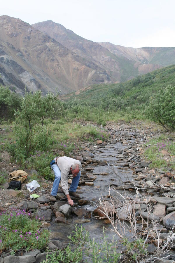
Sampling Stream Water in Denali National Park, Alaska
Sampling Stream Water in Denali National Park, AlaskaEd Pfeifer of the USGS Southwest Geographic Science Team collecting water samples during field work for a study of Dall sheep habitat in Denali National Park, Alaska.
Sampling Stream Water in Denali National Park, Alaska
Sampling Stream Water in Denali National Park, AlaskaEd Pfeifer of the USGS Southwest Geographic Science Team collecting water samples during field work for a study of Dall sheep habitat in Denali National Park, Alaska.
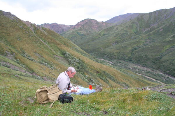
Dall Sheep Habitat, Denali National Park, Alaska
Ed Pfeifer of the USGS Southwest Geographic Science Team recording field notes in alpine tundra during a field study of Dall sheep habitat in Denali National Park, Alaska, on July 29, 2009
Ed Pfeifer of the USGS Southwest Geographic Science Team recording field notes in alpine tundra during a field study of Dall sheep habitat in Denali National Park, Alaska, on July 29, 2009

Fireweed and Beaver Creek, Alaska
Fireweed gains a foothold in a burn area of the White Mountains in Alaska.
Fireweed gains a foothold in a burn area of the White Mountains in Alaska.

Alaska Coastal Marsh
Coastal Marsh along Cook Inlet across from Anchorage Alaska.
Coastal Marsh along Cook Inlet across from Anchorage Alaska.

Geologic Studies on Sitkinak Island, Alaska
Geologists driving a core into marsh sediment to document interbedded peat and silt that records sudden vertical land movements associated with megathrust fault slip during large earthquakes.
Geologists driving a core into marsh sediment to document interbedded peat and silt that records sudden vertical land movements associated with megathrust fault slip during large earthquakes.