
...to informing restoration efforts in the Florida Everglades
...to tracking storm-related flood conditions through the South Atlantic...
...to investigating coral health in the Florida Keys & Caribbean...
...to assessing environmental contaminants on aquatic life in the Mississippi River Basin...
...USGS science spans the South Atlantic, Gulf States and Caribbean
The Southeast Region includes 13 states and two U.S. territories, Puerto Rico and the U.S. Virgin Islands
The Southeast Region includes 13 states and two U.S. territories, Puerto Rico and the U.S. Virgin Islands
Southeast Region
We conduct impartial, multi- and interdisciplinary research and monitoring to address a broad range of natural-resource issues that affect the quality of life of citizens and landscapes in the Southeastern United States and the Caribbean region.
News
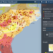
New Nationwide Tool Helps Answer: Do We Have Enough Water?
New Nationwide Tool Helps Answer: Do We Have Enough Water?
SPCMSC and University of Miami Scientists Collaborate on New Experiments to Guide National Park Service Coral Restoration Plans
SPCMSC and University of Miami Scientists Collaborate on New Experiments to Guide National Park Service Coral Restoration Plans
AquaDePTH: Merging Aquatic Disease Surveillance Data into One Useful Tool
AquaDePTH: Merging Aquatic Disease Surveillance Data into One Useful Tool
Publications
Phytoplankton responses to experimental nitrogen and phosphorus loading in the eutrophic and colored Caloosahatchee River, Florida Phytoplankton responses to experimental nitrogen and phosphorus loading in the eutrophic and colored Caloosahatchee River, Florida
The Caloosahatchee River, located in southwest Florida, is a eutrophic and colored river that flows from Lake Okeechobee westward into its estuary and the Gulf of America. Cyanobacterial harmful algal blooms (HABs) are a documented problem along this freshwater-to-marine waterway where nutrient enrichment has been identified as a key factor in bloom occurrence but has not been...
Simulation of groundwater flow to evaluate hydrogeologic controls on a PFAS plume, Coakley Landfill Superfund Site, Rockingham County, New Hampshire Simulation of groundwater flow to evaluate hydrogeologic controls on a PFAS plume, Coakley Landfill Superfund Site, Rockingham County, New Hampshire
Per- and polyfluoroalkyl substances (PFAS), including perfluorooctanoic acid (PFOA) and perfluorooctanesulfonic acid (PFOS), have been detected at combined concentrations above 2,000 nanograms per liter (ng/L) at groundwater seep locations near the Coakley Landfill Superfund site, in North Hampton, New Hampshire. The landfill was active from 1972 to 1985. An impermeable cap was placed on...
How wildlife respond to tropical cyclones: Short-term tactics and long-term impacts How wildlife respond to tropical cyclones: Short-term tactics and long-term impacts
From butterflies to lizards and from sharks to seabirds, wildlife exhibit tactics to survive the impacts of tropical cyclones, also known as hurricanes, cyclones, or typhoons depending on where they occur. Some species seek refuge during the storm by moving, some remain in place and ride it out, and others move longer distances, avoiding the main impacts of the storm altogether. Tropical...
Science

Mobile River Basin Study
The Mobile River Basin in Alabama, Georgia, Mississippi, and Tennessee is one of the 59 study units that are part of the U.S. Geological Survey's National Water-Quality Assessment (NAWQA) Program. The long-term goals of this program are to describe the status and trends in the quality of a large, representative part of the Nation's surface- and ground-water resources, and to provide a sound...
South Atlantic Water Science Center Drought Monitoring
When rainfall is less than normal for several weeks, months, or years, the flow of streams and rivers declines, water levels in lakes and reservoirs fall, and the depth to water in wells increases. If dry weather persists and water-supply problems develop, the dry period can become a drought.

Triangle Area, NC, Water Supply Monitoring
The Research Triangle area, located within the upper Cape Fear and Neuse River basins, is one of the most rapidly developing areas in the Nation. Growth has increased demand for water from public suppliers, the majority of which draw water from streams and lakes in the region. Growth also brings the threat of greater loads of contaminants and new contaminant sources that, if not properly managed...