
LCMAP Change Stories: Building a Boomtown, Block by Block
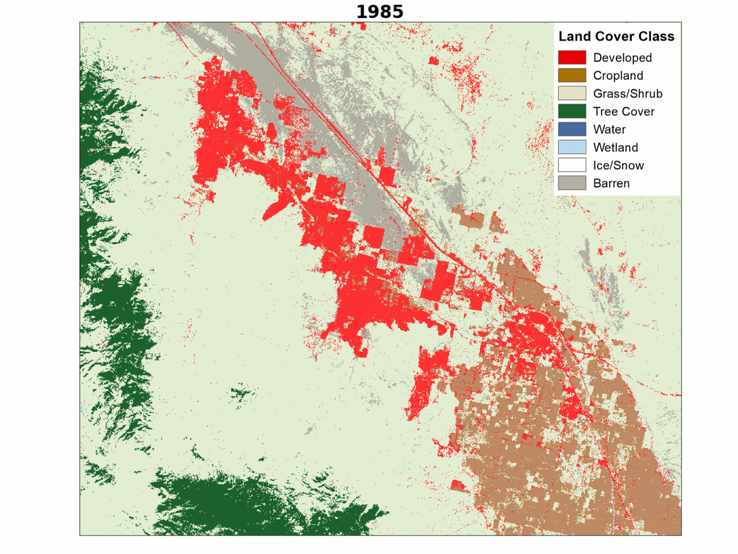
The desert outpost of Palm Springs, California and the surrounding Thousand Palms region has experienced explosive population growth over the past four decades, with tract after tract of development filling in previously barren landscapes along Interstate 10.
Explosive as the growth may be, it follows a relatively orderly pattern. A year-by-year look at Primary Land Cover data from the USGS Land Change Monitoring, Assessment, and Projection (LCMAP) initiative can tease out details on the emergence of that development that a before-and-after snapshot would miss.
Pay close attention to red plots of developed land cover in this animation. Expansion often starts with the construction of a gridded main road system, a change that carves a red border around squares of gray barren land, brown cropland or tan grassland or shrubland. These squares eventually fill in with the dense housing developments, residential streets, golf courses and associated recreational facilities that replace the sparse desert vegetation found in the region naturally.
Explore more LCMAP Change Stories by following the links below.

LCMAP Change Stories: Gone in 60 Seconds
LCMAP Change Stories: It's a Sprawl World After All

LCMAP Change Stories: Hurricanes in the Everglades

LCMAP Change Stories: Alabama Tornadoes
The desert outpost of Palm Springs, California and the surrounding Thousand Palms region has experienced explosive population growth over the past four decades, with tract after tract of development filling in previously barren landscapes along Interstate 10.
Explosive as the growth may be, it follows a relatively orderly pattern. A year-by-year look at Primary Land Cover data from the USGS Land Change Monitoring, Assessment, and Projection (LCMAP) initiative can tease out details on the emergence of that development that a before-and-after snapshot would miss.
Pay close attention to red plots of developed land cover in this animation. Expansion often starts with the construction of a gridded main road system, a change that carves a red border around squares of gray barren land, brown cropland or tan grassland or shrubland. These squares eventually fill in with the dense housing developments, residential streets, golf courses and associated recreational facilities that replace the sparse desert vegetation found in the region naturally.
Explore more LCMAP Change Stories by following the links below.
LCMAP Change Stories: Gone in 60 Seconds
LCMAP Change Stories: It's a Sprawl World After All
LCMAP Change Stories: Hurricanes in the Everglades