
Nautilus dive on the Mona Rift western slope, off the coast of Puerto Rico.
Claudia Flores
I support technical staff on various projects that need expertise in earthquake seismology, active source seismic processing both on land and marine and general geophysics such as gravity and magnetics. I have also done some work as a protected species observer (PPO). Finally, I provide Spanish translation for project support when needed.
Science and Products

Significant Earthquakes on a major fault system in Hispaniola, Puerto Rico, the Virgin Islands, and the Lesser Antilles, 1500–2010: Implications for Seismic Hazard
Earthquakes have been documented in the northeastern Caribbean since the arrival of Columbus to the Americas; written accounts of these felt earthquakes exist in various parts of the world. To better understand the earthquake cycle in the Caribbean, the records of earthquakes in earlier catalogs and historical documents from various archives, which are now available online, were critically...

Caribbean Tsunami and Earthquake Hazards Studies- Models
The Puerto Rico trench exhibits great water depth, extremely low gravity anomaly, and a tilted carbonate platform between (reconstructed) elevations of +1300 m and -4000 m. we suggest that these features are manifestations of large vertical movements of a segment of the Puerto Rico Trench, its forearc, and the island of Puerto Rico that took place 3.3 m.y. ago over a time period as short as 14-40...

Caribbean Tsunami and Earthquake Hazards Studies- Stress Changes and Earthquake Hazard
Strike-slip faults in the forearc region of a subduction zone often present significant seismic hazard because of their proximity to population centers. We explore the interaction between thrust events on the subduction interface and strike-slip faults within the forearc region using 3-D models of static Coulomb stress change.

Caribbean Tsunami and Earthquake Hazards Studies-Tsunami Potential
Newly-acquired multibeam bathymetry of the entire Puerto Rico trench reveals numerous retrograde slope failures at various scales at the edge of the carbonate platform north of Puerto Rico and the Virgin Islands. The slumped material comprises carbonate blocks, which are cohesive and the edge of the carbonate platform is steeper than most continental slopes, resulting in a higher potential runup...

Caribbean Tsunami and Earthquake Hazards Studies- Seafloor Map
To help understand the origin of the unusual bathymetry, gravity, and vertical tectonics of the plate boundary and to provide constraints for hazard assessment, the morphology of the entire 770-km-long trench from the Dominican Republic in the west to Anguilla in the east was mapped with multibeam echosounder during three cruises in 2002 and 2003. Parts of the Puerto Rico Trench were previously...

Caribbean Tsunami and Earthquake Hazards Studies
Puerto Rico and the Virgin Islands are located at an active plate boundary between the North American plate and the northeast corner of the Caribbean plate. Plate movements have caused large magnitude earthquakes and devastating tsunamis. The USGS has an ongoing program to identify and map the faults in this region using various geophysical and geological methods in order to estimate the location...
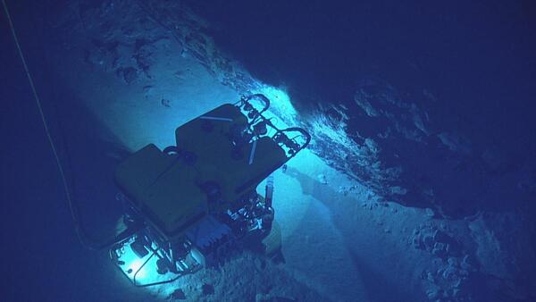
Mona Rift Seafloor
Nautilus dive on the Mona Rift western slope, off the coast of Puerto Rico.
Mona Rift Seafloor
Nautilus dive on the Mona Rift western slope, off the coast of Puerto Rico.
Nautilus dive on the Mona Rift western slope, off the coast of Puerto Rico.

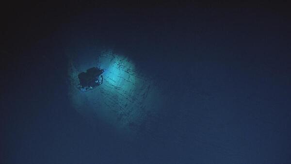
ROV and Mona Rift dive site
(Top): Map of dives labeled and shown in red and orange located near the Mona Rift, northwest of Puerto Rico. Contours show depths in meters at 500 m intervals. Square indicates location of dive. Bathymetry from Andrews et al. Yellow curve denotes landslide tsunami source of Lopéz-Venegas et al.
(Top): Map of dives labeled and shown in red and orange located near the Mona Rift, northwest of Puerto Rico. Contours show depths in meters at 500 m intervals. Square indicates location of dive. Bathymetry from Andrews et al. Yellow curve denotes landslide tsunami source of Lopéz-Venegas et al.
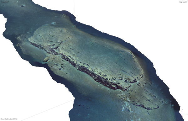
3D Mona Rift Model
A recent study from the U.S. Geological Survey offers a workflow for generating virtual maps of the deep seafloor from archived exploration dives. This work can help advance exploration of the deep-sea frontier and extends into other fields.
A recent study from the U.S. Geological Survey offers a workflow for generating virtual maps of the deep seafloor from archived exploration dives. This work can help advance exploration of the deep-sea frontier and extends into other fields.
Science and Products
Significant Earthquakes on a major fault system in Hispaniola, Puerto Rico, the Virgin Islands, and the Lesser Antilles, 1500–2010: Implications for Seismic Hazard
Earthquakes have been documented in the northeastern Caribbean since the arrival of Columbus to the Americas; written accounts of these felt earthquakes exist in various parts of the world. To better understand the earthquake cycle in the Caribbean, the records of earthquakes in earlier catalogs and historical documents from various archives, which are now available online, were critically...
Caribbean Tsunami and Earthquake Hazards Studies- Models
The Puerto Rico trench exhibits great water depth, extremely low gravity anomaly, and a tilted carbonate platform between (reconstructed) elevations of +1300 m and -4000 m. we suggest that these features are manifestations of large vertical movements of a segment of the Puerto Rico Trench, its forearc, and the island of Puerto Rico that took place 3.3 m.y. ago over a time period as short as 14-40...
Caribbean Tsunami and Earthquake Hazards Studies- Stress Changes and Earthquake Hazard
Strike-slip faults in the forearc region of a subduction zone often present significant seismic hazard because of their proximity to population centers. We explore the interaction between thrust events on the subduction interface and strike-slip faults within the forearc region using 3-D models of static Coulomb stress change.
Caribbean Tsunami and Earthquake Hazards Studies-Tsunami Potential
Newly-acquired multibeam bathymetry of the entire Puerto Rico trench reveals numerous retrograde slope failures at various scales at the edge of the carbonate platform north of Puerto Rico and the Virgin Islands. The slumped material comprises carbonate blocks, which are cohesive and the edge of the carbonate platform is steeper than most continental slopes, resulting in a higher potential runup...
Caribbean Tsunami and Earthquake Hazards Studies- Seafloor Map
To help understand the origin of the unusual bathymetry, gravity, and vertical tectonics of the plate boundary and to provide constraints for hazard assessment, the morphology of the entire 770-km-long trench from the Dominican Republic in the west to Anguilla in the east was mapped with multibeam echosounder during three cruises in 2002 and 2003. Parts of the Puerto Rico Trench were previously...
Caribbean Tsunami and Earthquake Hazards Studies
Puerto Rico and the Virgin Islands are located at an active plate boundary between the North American plate and the northeast corner of the Caribbean plate. Plate movements have caused large magnitude earthquakes and devastating tsunamis. The USGS has an ongoing program to identify and map the faults in this region using various geophysical and geological methods in order to estimate the location...
Mona Rift Seafloor
Nautilus dive on the Mona Rift western slope, off the coast of Puerto Rico.
Nautilus dive on the Mona Rift western slope, off the coast of Puerto Rico.
Mona Rift Seafloor
Nautilus dive on the Mona Rift western slope, off the coast of Puerto Rico.
Nautilus dive on the Mona Rift western slope, off the coast of Puerto Rico.
ROV and Mona Rift dive site
(Top): Map of dives labeled and shown in red and orange located near the Mona Rift, northwest of Puerto Rico. Contours show depths in meters at 500 m intervals. Square indicates location of dive. Bathymetry from Andrews et al. Yellow curve denotes landslide tsunami source of Lopéz-Venegas et al.
(Top): Map of dives labeled and shown in red and orange located near the Mona Rift, northwest of Puerto Rico. Contours show depths in meters at 500 m intervals. Square indicates location of dive. Bathymetry from Andrews et al. Yellow curve denotes landslide tsunami source of Lopéz-Venegas et al.
3D Mona Rift Model
A recent study from the U.S. Geological Survey offers a workflow for generating virtual maps of the deep seafloor from archived exploration dives. This work can help advance exploration of the deep-sea frontier and extends into other fields.
A recent study from the U.S. Geological Survey offers a workflow for generating virtual maps of the deep seafloor from archived exploration dives. This work can help advance exploration of the deep-sea frontier and extends into other fields.