
Frederick D. Day-Lewis (Former Employee)
Science and Products

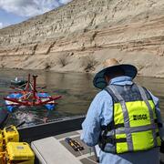
Hydrogeophysics Core Technology Team
About the Research. The Hydrogeophysics Core Technology Team (CTT) as part of the Environmental Health Program specializes in locating and quantifying exchanges of groundwater and surface water, along with characterizing geologic structure and mapping hydrologic connectivity across varied landscapes.

Fiber-Optic Distributed Temperature Sensing Technology for Surface-Water and Groundwater Studies
Fiber-optic distributed temperature sensing (FO-DTS) technology can be used for characterizing estuary-aquifer and stream-aquifer interaction and for identifying transmissive fractures in bedrock boreholes.
Geophysics for USGS Groundwater/Surface Water Exchange Studies
Locating and quantifying exchanges of groundwater and surface water, along with characterizing geologic structure, is essential to water-resource managers and hydrologists for the development of effective water-resource policy, protection, and management. The USGS conducts applied research to evaluate the use of new or emerging hydrogeophysical tools and methods to improve our understanding of...

Optimized Enhanced Bioremediation through 4D Geophysical Monitoring and Autonomous Data Collection, Processing, and Analysis
The USGS Office of Ground Water, Branch of Geophysics (OGW BG) is collaborating on an applied research project to evaluate the use of new hydrogeophysical tools to remotely monitor and visualize subsurface bioremediation amendment emplacement and transport in near real-time. The project, funded by the U.S. Department of Defense Environmental Security Technology Certification Program, could provide...

Fiber-Optic Distributed Temperature Sensing in Waquoit Bay, Massachusetts
In 2006 the USGS Office of Groundwater, Branch of Geophysics (OGW BG) conducted a technology demonstration and evaluation project in Waquoit Bay, East Falmouth, Massachusetts, to evaluate the use of fiber-optic distributed temperature sensing (FO-DTS). In this project, the USGS used FO-DTS to investigate aquifer-estuary interaction by monitoring submarine groundwater discharge in Waquoit Bay. OGW...
Science and Products
Hydrogeophysics Core Technology Team
About the Research. The Hydrogeophysics Core Technology Team (CTT) as part of the Environmental Health Program specializes in locating and quantifying exchanges of groundwater and surface water, along with characterizing geologic structure and mapping hydrologic connectivity across varied landscapes.
Fiber-Optic Distributed Temperature Sensing Technology for Surface-Water and Groundwater Studies
Fiber-optic distributed temperature sensing (FO-DTS) technology can be used for characterizing estuary-aquifer and stream-aquifer interaction and for identifying transmissive fractures in bedrock boreholes.
Geophysics for USGS Groundwater/Surface Water Exchange Studies
Locating and quantifying exchanges of groundwater and surface water, along with characterizing geologic structure, is essential to water-resource managers and hydrologists for the development of effective water-resource policy, protection, and management. The USGS conducts applied research to evaluate the use of new or emerging hydrogeophysical tools and methods to improve our understanding of...
Optimized Enhanced Bioremediation through 4D Geophysical Monitoring and Autonomous Data Collection, Processing, and Analysis
The USGS Office of Ground Water, Branch of Geophysics (OGW BG) is collaborating on an applied research project to evaluate the use of new hydrogeophysical tools to remotely monitor and visualize subsurface bioremediation amendment emplacement and transport in near real-time. The project, funded by the U.S. Department of Defense Environmental Security Technology Certification Program, could provide...
Fiber-Optic Distributed Temperature Sensing in Waquoit Bay, Massachusetts
In 2006 the USGS Office of Groundwater, Branch of Geophysics (OGW BG) conducted a technology demonstration and evaluation project in Waquoit Bay, East Falmouth, Massachusetts, to evaluate the use of fiber-optic distributed temperature sensing (FO-DTS). In this project, the USGS used FO-DTS to investigate aquifer-estuary interaction by monitoring submarine groundwater discharge in Waquoit Bay. OGW...