An official website of the United States government
Here's how you know
Official websites use .gov
A .gov website belongs to an official government organization in the United States.
Secure .gov websites use HTTPS
A lock () or https:// means you’ve safely connected to the .gov website. Share sensitive information only on official, secure websites.
The Hydrogeophysics Core Technology Team (CTT) as part of the Environmental Health Program specializes in locating and quantifying exchanges of groundwater and surface water, along with characterizing geologic structure and mapping hydrologic connectivity across varied landscapes.
The Hydrogeophysics CTT conducts applied research and methods development to evaluate the use of emerging hydrogeophysical tools and methods to improve our understanding of hydrologic processes.
“If there is magic on this planet, it is contained in water.” -Loren Eiseley
The Hydrogeophysics CTT harnesses that magic using natural and induced geophysical signals to measure a range of hydrogeologic parameters relevant to the research of Integrated Science Teams.
USGS Research Hydrologists Neil Terry and Marty Briggs review fiber-optic distributed temperature sensing (FO-DTS) data with Dale Werkema of the U.S. Environmental Protection Agency as the data are collected along Cement Creek near Silverton, Colorado, in September 2019 to determine the locations of mine drainage inflows to the stream.
For example, geophysical methods based on measuring the electrical, thermal, and (or) physical properties of surface water, groundwater, and the shallow subsurface can enable the efficient geolocation and quantification of groundwater and surface-water related processes. Such spatially comprehensive and spatially distributed information can tie point measurements to larger geologic structures and ecological processes impacting flow and transport at local and regional scales. Similar data types collected over time (i.e., time-lapse data) allow researchers to track highly dynamic processes such as the movement of contaminant plumes, soil moisture, and saltwater intrusion. As a result, we are better able to understand and forecast movement of water between groundwater and surface-water bodies and associated changes in water quality and quantity.
The Hydrogeophysics CTT has been a leader in advancing the use of hydrogeophysics to study groundwater/surface-water exchange, groundwater process, and controlling geology for decades via methods and software development and pioneering research. Current efforts continue to foster innovation and development of hydrogeophysical technologies and methodologies to answer important questions related to PFAS and metals fate and transport, HABs, and other pressing EH research goals.
Key Capabilities
Land Surface Geophysical Capabilities
tTEM (towed transient EM); Minerals IST, Leadville, CO
ERT – electrical resistivity tomography; Williston, ND Energy IST
EM (GEM, DualEM, TEM); Energy IST, Williston, ND; Minerals IST, Silverton, CO; Minerals IST, Leadville, CO
Seismic refraction
MASW – multi-channel analysis of surface wave
Passive seismic (H/V); PFAS IST, Cape Cod, MA
GPR – ground penetrating radar
sNMR; EH Methods Development
Waterborne and Wetland Capabilities
Vertical temperature profiling of streambed exchange fluxes; EH Methods Development; PFAS IST, Cape Cod, MA; Energy IST, Williston, ND; Minerals IST, Silverton, CO
Fiber-Optic DTS; PFAS IST, Cape Cod, MA; Minerals IST, Silverton, CO
TIR – thermal infrared; PFAS IST, Cape Cod, MA; Minerals IST, Silverton, CO; Minerals IST, Leadville, CO
Air-Water Temperature logging; EH Methods Development; PFAS IST, Cape Cod, MA; Minerals IST, Silverton, CO Water tracer methods; Minerals IST, Leadville, CO
FloaTEM (towed TEM)
CRP – continuous resistivity profiling
EM (GEM); PFAS IST, Cape Cod, MA; Minerals IST, Silverton, CO; Energy IST, Williston, ND
CSP – continuous seismic
Monitoring Well and Borehole Geophysical Capabilities
View looking down at a remediation research area, Loring Air Force Base, Maine. White tubing is part of the steam injection setup. USGS scientists conducted geophysical borehole surveys to determine if borehole radar could be used to monitor the steam injection remediation.(Public domain.)
Caliper
Fluid Temp and Resistivity
Natural Gamma
Resistivity, SP, SPR
EMI – electromagnetic induction
Magnetic susceptibility
OTV and ATV imaging
Camera
Flowmeters (EM and HeatPulse)
Dye dilution
FWS – full waveform sonic
Spectral Gamma
Induced polarization
Non-directional radar
bNMR – nuclear magnetic resonance (multiple tools); EH Methods Development
Uncrewed Aircraft Capabilities
Visual Imaging (RGB); Energy IST, Bemidji, MN; PFAS IST, Cape Cod, MA
TIR; PFAS IST, Cape Cod, MA
GPR
Multi-spectral Imaging
† Hypertext links to non-USGS products and services; and the use of trade names, trademarks, company names, or other references to non-USGS products and services are provided for information only and do not constitute endorsement or warranty by the U.S. Geological Survey (USGS), U.S. Department of the Interior, or U.S. Government.
Environmental Health Integrated Science Team Collaborators
The Energy Resources Life Cycle Integrated Science Team focuses on the potential for environmental contaminant exposures that might originate from energy resource activities including extraction, production, transportation, storage, waste management, and restoration. Perceived health risks to humans and other organisms will be distinguished from actual risks, if any. If actual risks are identified...
Energy Resources Life Cycle Integrated Science Team
The Energy Resources Life Cycle Integrated Science Team focuses on the potential for environmental contaminant exposures that might originate from energy resource activities including extraction, production, transportation, storage, waste management, and restoration. Perceived health risks to humans and other organisms will be distinguished from actual risks, if any. If actual risks are identified...
The team studies toxicants and pathogens in water resources from their sources, through watersheds, aquifers, and infrastructure to human and wildlife exposures. That information is used to develop decision tools that protect human and wildlife health.
Drinking Water and Wastewater Infrastructure Science Team
The team studies toxicants and pathogens in water resources from their sources, through watersheds, aquifers, and infrastructure to human and wildlife exposures. That information is used to develop decision tools that protect human and wildlife health.
Increasing scientific and public awareness of the widespread distribution of per- and poly-fluoroalkyl substances (PFAS) in U.S. drinking-water supplies, aquatic and terrestrial ecosystems, wildlife, and humans has raised many public health and resource management questions that U.S. Geological Survey's (USGS) science can inform. The USGS Environmental Health Program's PFAS Integrated Science Team...
Per-and Polyfluoroalkyl Substances (PFAS) Integrated Science Team
Increasing scientific and public awareness of the widespread distribution of per- and poly-fluoroalkyl substances (PFAS) in U.S. drinking-water supplies, aquatic and terrestrial ecosystems, wildlife, and humans has raised many public health and resource management questions that U.S. Geological Survey's (USGS) science can inform. The USGS Environmental Health Program's PFAS Integrated Science Team...
USGS scientists are using high-resolution handheld and airborne thermal imaging cameras in groundwater/surface-water exchange studies and other investigations where surface temperature contrasts indicate various hydrological processes. These cameras are used to quickly locate and characterize thermal (temperature) anomalies along streams, lakes, wetlands, estuaries, and across the landscape...
Thermal Imaging Cameras for Studying Groundwater/Surface-Water Exchange
USGS scientists are using high-resolution handheld and airborne thermal imaging cameras in groundwater/surface-water exchange studies and other investigations where surface temperature contrasts indicate various hydrological processes. These cameras are used to quickly locate and characterize thermal (temperature) anomalies along streams, lakes, wetlands, estuaries, and across the landscape...
Locating and quantifying exchanges of groundwater and surface water, along with characterizing geologic structure, is essential to water-resource managers and hydrologists for the development of effective water-resource policy, protection, and management. The USGS conducts applied research to evaluate the use of new or emerging hydrogeophysical tools and methods to improve our understanding of...
Geophysics for USGS Groundwater/Surface Water Exchange Studies
Locating and quantifying exchanges of groundwater and surface water, along with characterizing geologic structure, is essential to water-resource managers and hydrologists for the development of effective water-resource policy, protection, and management. The USGS conducts applied research to evaluate the use of new or emerging hydrogeophysical tools and methods to improve our understanding of...
Surface and water-borne geophysical methods can provide information for the characterization of the subsurface structure of the earth for aquifer investigations. Floating and towed transient electromagnetic (FloaTEM and tTEM) surveys provide resistivity soundings of the subsurface, which can be related to lithology and hydrogeology. In the TEM method, a primary electrical current is...
As the climate warms and dry periods become more extreme, shallow groundwater discharge is generally becoming a less reliable source of streamflow while deep groundwater discharge remains a more resilient source. The implications of shifts in the relative balance of shallow and deep groundwater discharge sources are profound in gaining streams. These different sources exert critical...
In summer in Massachusetts, USA, preferential groundwater discharge zones are often colder than adjacent streambed areas that do not have substantial discharge. Therefore, discharge zones can efficiently be identified and mapped over space using heat as a tracer. This data release contains fiber-optic distributed temperature sensing (FO-DTS) data collected along the streambed interface...
This data release provides a recursive-estimation framework to infer groundwater/surface-water exchange based on temperature time series collected at different vertical depths below the sediment/water interface. A heat-transport problem was formulated as a state-space model (SSM), in which the spatial derivatives in the convection/conduction equation are approximated using finite...
Locations of focused groundwater seepage to surface water are often hydrologically and ecologically important. Spatially focused or 'preferential' seepage can be identified as anomalous cold zones compared to warmer adjacent bank and surface water features (in summer). The temperature of deeper groundwater on Cape Cod is expected to approximate 11 degrees Celsius year-round, yielding a...
Locations of focused (or ‘preferential’) groundwater discharge to surface water are often hydrologically and ecologically important, yet our ability to predict the spatial distribution and water quality of preferential riverbank discharges is limited at the scale of river networks. To advance the understanding of the physical controls on riverbank groundwater discharge processes...
The temperature and surface geophysical data contained in this release have primarily been collected to support groundwater/surface water methods development, and to characterize the hydrogeological controls on native brook trout habitat. All data have been collected since 2010 along the Quashnet River corridor located on Cape Cod, MA, USA. Cape Cod is a peninsula in southeastern coastal
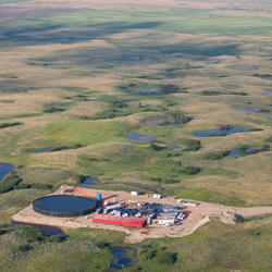
The extraction of unconventional oil and gas (UOG) resources often produces highly saline waste waters, which can be released to the river corridor environment during spills and pipe leakage. In North Dakota, USA more than 8,000 spills were recorded from 2008-2015, and more than half of those spills were related to pipelines. Data collected for this study were related to UOG wastewater...
Near-surface geophysical data from within the Bonita Peak Mining District in Silverton, Colorado, USA are presented. The data include fiber optic distributed temperature sensing (FO-DTS) and frequency domain electromagnetic induction (FDEM) data collected in and around roughly 1 km reaches of Cement Creek and California Gulch. Additional data, including ground penetrating radar (GPR) and...
This data release contains waterborne self-potential (SP) logging data measured during 48 laboratory experiments and three field experiments that were performed to develop an efficient, accurate method for detecting (in the laboratory) and geolocating (in the field) focused vertical groundwater discharge (surface-water gains) and recharge (surface-water losses) in a river. The...
The U.S. Geological Survey is studying the interaction of a contaminated groundwater plume enriched in uranium and other trace elements with water, sediment, and biota along a 3 km reach of the Little Wind River in central Wyoming. The source of the contaminants is from a reclaimed uranium mill site near Riverton, Wyoming. The study is being done in collaboration with the Department of...
The U.S. Geological Survey collected low-altitude (typically 200-350 ft als) airborne thermal infrared, multispectral, and visual imagery data via a multirotor, small unoccupied aircraft system deployed along beaver-impacted sections of the East River and Coal Creek stream corridors, near the town of Crested Butte, CO. Visual imagery was collected in jpg format, and the images were...
Groundwater that drains to surface water through seeps and springs is generally referred to as “discharge.” Groundwater discharge is a primary component of stream base flow, or streamflow that occurs between storms, periods of snowmelt runoff, and periods of quick soil drainage. Streams that gain groundwater as they flow are common across glaciated regions such as the Delaware River Basin, and the...
A fiber-optic distributed temperature sensing monitoring array installed along Cement Creek near Silverton, Colorado.
A long-term fiber-optic distributed temperature sensing monitoring array installed along Cement Creek near Silverton CO to track acid mine influenced groundwater discharge to the creek over time.
A long-term fiber-optic distributed temperature sensing monitoring array installed along Cement Creek near Silverton CO to track acid mine influenced groundwater discharge to the creek over time.
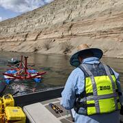
Floating an electromagnetic imaging tool along a coastal area in Massachusetts.
Eric White and Patrick Scordato of the USGS float an electromagnetic imaging tool along a coastal area in Massachusetts to identify terrestrial groundwater discharge that may be impacted by PFAS contamination.
Eric White and Patrick Scordato of the USGS float an electromagnetic imaging tool along a coastal area in Massachusetts to identify terrestrial groundwater discharge that may be impacted by PFAS contamination.
USGS Hydrologist Conducts FloaTEM Geophysical Survey on River
USGS Hydrologist Eric White monitors a computer displaying real-time data inversions while towing a novel floating transient electromagnetic (TEM) system (i.e., FloaTEM) on the Columbia River near Richland, Washington, adjacent to the Hanford 300 Area.
USGS Hydrologist Eric White monitors a computer displaying real-time data inversions while towing a novel floating transient electromagnetic (TEM) system (i.e., FloaTEM) on the Columbia River near Richland, Washington, adjacent to the Hanford 300 Area.
Groundwater drains to the land surface, generating the baseflow of streams, lakes, and wetlands. The hydrologic resilience of baseflow during prolonged dry periods and after disturbance can be assessed with evolving remote sensing analysis paired with localized monitoring of groundwater drainage features and creative model calibration strategies.
Riverbank groundwater discharge faces are spatially extensive areas of preferential seepage that are exposed to air at low river flow. Some conceptual hydrologic models indicate discharge faces represent the spatial convergence of highly variable age and length groundwater flowpaths, while others indicate greater consistency in source groundwater characteristics. Our detailed field...
Authors
Adam Haynes, Martin A. Briggs, Eric Moore, Kevin Jackson, James Knighton, David M. Rey, Ashley Helton
Groundwater is critical for maintaining stream baseflow and thermal stability; however, the influence of groundwater on streamflow has been difficult to evaluate at broad spatial scales. Techniques such as baseflow separation necessitate streamflow records and do not directly indicate whether groundwater inflow may be sourced from more dynamic shallow flowpaths. We present a web tool...
Authors
Danielle K. Hare, Susanne A. Benz, Barret L. Kurylyk, Zachary Johnson, Neil C. Terry, Ashley M. Helton
Within the western United States, increasingly severe and frequent wildfires may alter the magnitude, timing, and quality of water exported from burned areas by streams. Post-fire hydrologic studies often focus on peak stream flow responses to shifts in runoff generation or on annual streamflow yield response to changes in evapotranspiration following fire. However, the magnitude and...
Authors
David M. Rey, Martin A. Briggs, Michelle A. Walvoord, Brian A. Ebel
Although groundwater exchange processes are known to modulate atmospheric influences on stream temperature and flow, the implications for ecological stability are poorly understood. Here, we evaluated temporal change in stream fish communities across a gradient of groundwater influence defined by karst terrain (carbonate parent materials) within the Potomac River basin of eastern North...
Authors
Nathaniel P. Hitt, Karli M. Rogers, Karmann G. Kessler, Martin A. Briggs, Jennifer H. Fair
The Riverton Processing site was a uranium mill 4 kilometers southwest of Riverton, Wyoming, that prepared uranium ore for nuclear reactors and weapons from 1958 to 1963. The U.S. Department of Energy completed surface remediation of the uranium tailings in 1989; however, groundwater below and downgradient from the tailings site and nearby Little Wind River was not remediated. Beginning...
Authors
David L. Naftz, Christopher C. Fuller, Robert L. Runkel, John Solder, W. Payton Gardner, Neil C. Terry, Martin A. Briggs, Terry M. Short, Daniel J. Cain, William L Dam, Patrick A. Byrne, James R. Campbell
In mountain headwater streams, the quality and resilience of summer cold-water habitat is generally regulated by stream discharge, longitudinal stream channel connectivity and groundwater exchange. These critical hydrologic processes are thought to be influenced by the stream corridor bedrock contact depth (sediment thickness), a parameter often inferred from sparse hillslope borehole...
Authors
Martin A. Briggs, Phillip J. Goodling, Zachary Johnson, Karli M. Rogers, Nathaniel P. Hitt, Jennifer H. Fair, Craig D. Snyder
We present and demonstrate a recursive-estimation framework to infer groundwater/surface-water exchange based on temperature time series collected at different vertical depths below the sediment/water interface. We formulate the heat-transport problem as a state-space model (SSM), in which the spatial derivatives in the convection/conduction equation are approximated using finite...
Authors
W. Anderson McAliley, Frederick Day-Lewis, David M. Rey, Martin A. Briggs, Allen M. Shapiro, Dale Werkema
Groundwater/surface-water (GW/SW) exchange and hyporheic processes are topics receiving increasing attention from the hydrologic community. Hydraulic, chemical, temperature, geophysical, and remote sensing methods are used to achieve various goals (e.g., inference of GW/SW exchange, mapping of bed materials, etc.), but the application of these methods is constrained by site conditions...
Authors
Steven Hammett, Frederick Day-Lewis, Brett Russell Trottier, Paul M. Barlow, Martin A. Briggs, Geoffrey N. Delin, Judson Harvey, Carole D. Johnson, John W. Lane, D.O. Rosenberry, Dale D. Werkema
Exchanges of groundwater and surface-water are fundamental to a wide range of water-supply and water-quality management issues but challenging to map beyond the reach scale. Waterborne gradient self-potential (SP) measurements are directly sensitive to water flow through riverbed sediments and can be used to infer exchange locations, direction (gain versus loss), scale, and relative...
Redox hot spots occurring as metal-rich anoxic groundwater discharges through oxic wetland and river sediments commonly result in the formation of iron (Fe) oxide precipitates. These redox-sensitive precipitates influence the release of nutrients and metals to surface water and can act as ‘contaminant sponges’ by absorbing toxic compounds. We explore the feasibility of a non-invasive...
Authors
Cheng-Hui Wang, Martin A. Briggs, Frederick Day-Lewis, L. Slater
Heat has been widely applied to trace groundwater‐surface water exchanges in inland environments, but it is infrequently applied in coastal sediment where head oscillations induce periodicity in water flux magnitude/direction and heat advection. This complicates interpretation of temperatures to estimate water fluxes. We investigate the convolution of thermal and hydraulic signals to...
Authors
N LeRoux, B. Kurylyk, Martin A. Briggs, D. Irvine, J Tamborski, V. F. Bense
The Groundwater/Surface-Water Method Selection Tool (GW/SW-MST) is a spreadsheet-based tool to help practitioners identify methods for use in groundwater/surface-water (GW/SW) exchange and hyporheic studies. GW/SW exchange and hyporheic processes are topics receiving increasing attention from the hydrologic community. Hydraulic, chemical, temperature, geophysical, and remote sensing...
DTSGUI is a public-domain software tool to import, manage, parse/cull, georeference, analyze and visualize fiber-optic distributed temperature sensor (FO-DTS) data. Visualization can efficiently be accomplished in the form of heat maps of temperature (as color) versus distance and time, and in map view plots of georeferenced data on land-surface orthoimagery. The code is written in...
The Hydrogeophysics Core Technology Team (CTT) as part of the Environmental Health Program specializes in locating and quantifying exchanges of groundwater and surface water, along with characterizing geologic structure and mapping hydrologic connectivity across varied landscapes.
The Hydrogeophysics CTT conducts applied research and methods development to evaluate the use of emerging hydrogeophysical tools and methods to improve our understanding of hydrologic processes.
“If there is magic on this planet, it is contained in water.” -Loren Eiseley
The Hydrogeophysics CTT harnesses that magic using natural and induced geophysical signals to measure a range of hydrogeologic parameters relevant to the research of Integrated Science Teams.
USGS Research Hydrologists Neil Terry and Marty Briggs review fiber-optic distributed temperature sensing (FO-DTS) data with Dale Werkema of the U.S. Environmental Protection Agency as the data are collected along Cement Creek near Silverton, Colorado, in September 2019 to determine the locations of mine drainage inflows to the stream.
For example, geophysical methods based on measuring the electrical, thermal, and (or) physical properties of surface water, groundwater, and the shallow subsurface can enable the efficient geolocation and quantification of groundwater and surface-water related processes. Such spatially comprehensive and spatially distributed information can tie point measurements to larger geologic structures and ecological processes impacting flow and transport at local and regional scales. Similar data types collected over time (i.e., time-lapse data) allow researchers to track highly dynamic processes such as the movement of contaminant plumes, soil moisture, and saltwater intrusion. As a result, we are better able to understand and forecast movement of water between groundwater and surface-water bodies and associated changes in water quality and quantity.
The Hydrogeophysics CTT has been a leader in advancing the use of hydrogeophysics to study groundwater/surface-water exchange, groundwater process, and controlling geology for decades via methods and software development and pioneering research. Current efforts continue to foster innovation and development of hydrogeophysical technologies and methodologies to answer important questions related to PFAS and metals fate and transport, HABs, and other pressing EH research goals.
Key Capabilities
Land Surface Geophysical Capabilities
tTEM (towed transient EM); Minerals IST, Leadville, CO
ERT – electrical resistivity tomography; Williston, ND Energy IST
EM (GEM, DualEM, TEM); Energy IST, Williston, ND; Minerals IST, Silverton, CO; Minerals IST, Leadville, CO
Seismic refraction
MASW – multi-channel analysis of surface wave
Passive seismic (H/V); PFAS IST, Cape Cod, MA
GPR – ground penetrating radar
sNMR; EH Methods Development
Waterborne and Wetland Capabilities
Vertical temperature profiling of streambed exchange fluxes; EH Methods Development; PFAS IST, Cape Cod, MA; Energy IST, Williston, ND; Minerals IST, Silverton, CO
Fiber-Optic DTS; PFAS IST, Cape Cod, MA; Minerals IST, Silverton, CO
TIR – thermal infrared; PFAS IST, Cape Cod, MA; Minerals IST, Silverton, CO; Minerals IST, Leadville, CO
Air-Water Temperature logging; EH Methods Development; PFAS IST, Cape Cod, MA; Minerals IST, Silverton, CO Water tracer methods; Minerals IST, Leadville, CO
FloaTEM (towed TEM)
CRP – continuous resistivity profiling
EM (GEM); PFAS IST, Cape Cod, MA; Minerals IST, Silverton, CO; Energy IST, Williston, ND
CSP – continuous seismic
Monitoring Well and Borehole Geophysical Capabilities
View looking down at a remediation research area, Loring Air Force Base, Maine. White tubing is part of the steam injection setup. USGS scientists conducted geophysical borehole surveys to determine if borehole radar could be used to monitor the steam injection remediation.(Public domain.)
Caliper
Fluid Temp and Resistivity
Natural Gamma
Resistivity, SP, SPR
EMI – electromagnetic induction
Magnetic susceptibility
OTV and ATV imaging
Camera
Flowmeters (EM and HeatPulse)
Dye dilution
FWS – full waveform sonic
Spectral Gamma
Induced polarization
Non-directional radar
bNMR – nuclear magnetic resonance (multiple tools); EH Methods Development
Uncrewed Aircraft Capabilities
Visual Imaging (RGB); Energy IST, Bemidji, MN; PFAS IST, Cape Cod, MA
TIR; PFAS IST, Cape Cod, MA
GPR
Multi-spectral Imaging
† Hypertext links to non-USGS products and services; and the use of trade names, trademarks, company names, or other references to non-USGS products and services are provided for information only and do not constitute endorsement or warranty by the U.S. Geological Survey (USGS), U.S. Department of the Interior, or U.S. Government.
Environmental Health Integrated Science Team Collaborators
The Energy Resources Life Cycle Integrated Science Team focuses on the potential for environmental contaminant exposures that might originate from energy resource activities including extraction, production, transportation, storage, waste management, and restoration. Perceived health risks to humans and other organisms will be distinguished from actual risks, if any. If actual risks are identified...
Energy Resources Life Cycle Integrated Science Team
The Energy Resources Life Cycle Integrated Science Team focuses on the potential for environmental contaminant exposures that might originate from energy resource activities including extraction, production, transportation, storage, waste management, and restoration. Perceived health risks to humans and other organisms will be distinguished from actual risks, if any. If actual risks are identified...
The team studies toxicants and pathogens in water resources from their sources, through watersheds, aquifers, and infrastructure to human and wildlife exposures. That information is used to develop decision tools that protect human and wildlife health.
Drinking Water and Wastewater Infrastructure Science Team
The team studies toxicants and pathogens in water resources from their sources, through watersheds, aquifers, and infrastructure to human and wildlife exposures. That information is used to develop decision tools that protect human and wildlife health.
Increasing scientific and public awareness of the widespread distribution of per- and poly-fluoroalkyl substances (PFAS) in U.S. drinking-water supplies, aquatic and terrestrial ecosystems, wildlife, and humans has raised many public health and resource management questions that U.S. Geological Survey's (USGS) science can inform. The USGS Environmental Health Program's PFAS Integrated Science Team...
Per-and Polyfluoroalkyl Substances (PFAS) Integrated Science Team
Increasing scientific and public awareness of the widespread distribution of per- and poly-fluoroalkyl substances (PFAS) in U.S. drinking-water supplies, aquatic and terrestrial ecosystems, wildlife, and humans has raised many public health and resource management questions that U.S. Geological Survey's (USGS) science can inform. The USGS Environmental Health Program's PFAS Integrated Science Team...
USGS scientists are using high-resolution handheld and airborne thermal imaging cameras in groundwater/surface-water exchange studies and other investigations where surface temperature contrasts indicate various hydrological processes. These cameras are used to quickly locate and characterize thermal (temperature) anomalies along streams, lakes, wetlands, estuaries, and across the landscape...
Thermal Imaging Cameras for Studying Groundwater/Surface-Water Exchange
USGS scientists are using high-resolution handheld and airborne thermal imaging cameras in groundwater/surface-water exchange studies and other investigations where surface temperature contrasts indicate various hydrological processes. These cameras are used to quickly locate and characterize thermal (temperature) anomalies along streams, lakes, wetlands, estuaries, and across the landscape...
Locating and quantifying exchanges of groundwater and surface water, along with characterizing geologic structure, is essential to water-resource managers and hydrologists for the development of effective water-resource policy, protection, and management. The USGS conducts applied research to evaluate the use of new or emerging hydrogeophysical tools and methods to improve our understanding of...
Geophysics for USGS Groundwater/Surface Water Exchange Studies
Locating and quantifying exchanges of groundwater and surface water, along with characterizing geologic structure, is essential to water-resource managers and hydrologists for the development of effective water-resource policy, protection, and management. The USGS conducts applied research to evaluate the use of new or emerging hydrogeophysical tools and methods to improve our understanding of...
Surface and water-borne geophysical methods can provide information for the characterization of the subsurface structure of the earth for aquifer investigations. Floating and towed transient electromagnetic (FloaTEM and tTEM) surveys provide resistivity soundings of the subsurface, which can be related to lithology and hydrogeology. In the TEM method, a primary electrical current is...
As the climate warms and dry periods become more extreme, shallow groundwater discharge is generally becoming a less reliable source of streamflow while deep groundwater discharge remains a more resilient source. The implications of shifts in the relative balance of shallow and deep groundwater discharge sources are profound in gaining streams. These different sources exert critical...
In summer in Massachusetts, USA, preferential groundwater discharge zones are often colder than adjacent streambed areas that do not have substantial discharge. Therefore, discharge zones can efficiently be identified and mapped over space using heat as a tracer. This data release contains fiber-optic distributed temperature sensing (FO-DTS) data collected along the streambed interface...
This data release provides a recursive-estimation framework to infer groundwater/surface-water exchange based on temperature time series collected at different vertical depths below the sediment/water interface. A heat-transport problem was formulated as a state-space model (SSM), in which the spatial derivatives in the convection/conduction equation are approximated using finite...
Locations of focused groundwater seepage to surface water are often hydrologically and ecologically important. Spatially focused or 'preferential' seepage can be identified as anomalous cold zones compared to warmer adjacent bank and surface water features (in summer). The temperature of deeper groundwater on Cape Cod is expected to approximate 11 degrees Celsius year-round, yielding a...
Locations of focused (or ‘preferential’) groundwater discharge to surface water are often hydrologically and ecologically important, yet our ability to predict the spatial distribution and water quality of preferential riverbank discharges is limited at the scale of river networks. To advance the understanding of the physical controls on riverbank groundwater discharge processes...
The temperature and surface geophysical data contained in this release have primarily been collected to support groundwater/surface water methods development, and to characterize the hydrogeological controls on native brook trout habitat. All data have been collected since 2010 along the Quashnet River corridor located on Cape Cod, MA, USA. Cape Cod is a peninsula in southeastern coastal
The extraction of unconventional oil and gas (UOG) resources often produces highly saline waste waters, which can be released to the river corridor environment during spills and pipe leakage. In North Dakota, USA more than 8,000 spills were recorded from 2008-2015, and more than half of those spills were related to pipelines. Data collected for this study were related to UOG wastewater...
Near-surface geophysical data from within the Bonita Peak Mining District in Silverton, Colorado, USA are presented. The data include fiber optic distributed temperature sensing (FO-DTS) and frequency domain electromagnetic induction (FDEM) data collected in and around roughly 1 km reaches of Cement Creek and California Gulch. Additional data, including ground penetrating radar (GPR) and...
This data release contains waterborne self-potential (SP) logging data measured during 48 laboratory experiments and three field experiments that were performed to develop an efficient, accurate method for detecting (in the laboratory) and geolocating (in the field) focused vertical groundwater discharge (surface-water gains) and recharge (surface-water losses) in a river. The...
The U.S. Geological Survey is studying the interaction of a contaminated groundwater plume enriched in uranium and other trace elements with water, sediment, and biota along a 3 km reach of the Little Wind River in central Wyoming. The source of the contaminants is from a reclaimed uranium mill site near Riverton, Wyoming. The study is being done in collaboration with the Department of...
The U.S. Geological Survey collected low-altitude (typically 200-350 ft als) airborne thermal infrared, multispectral, and visual imagery data via a multirotor, small unoccupied aircraft system deployed along beaver-impacted sections of the East River and Coal Creek stream corridors, near the town of Crested Butte, CO. Visual imagery was collected in jpg format, and the images were...
Groundwater that drains to surface water through seeps and springs is generally referred to as “discharge.” Groundwater discharge is a primary component of stream base flow, or streamflow that occurs between storms, periods of snowmelt runoff, and periods of quick soil drainage. Streams that gain groundwater as they flow are common across glaciated regions such as the Delaware River Basin, and the...
A fiber-optic distributed temperature sensing monitoring array installed along Cement Creek near Silverton, Colorado.
A long-term fiber-optic distributed temperature sensing monitoring array installed along Cement Creek near Silverton CO to track acid mine influenced groundwater discharge to the creek over time.
A long-term fiber-optic distributed temperature sensing monitoring array installed along Cement Creek near Silverton CO to track acid mine influenced groundwater discharge to the creek over time.
Floating an electromagnetic imaging tool along a coastal area in Massachusetts.
Eric White and Patrick Scordato of the USGS float an electromagnetic imaging tool along a coastal area in Massachusetts to identify terrestrial groundwater discharge that may be impacted by PFAS contamination.
Eric White and Patrick Scordato of the USGS float an electromagnetic imaging tool along a coastal area in Massachusetts to identify terrestrial groundwater discharge that may be impacted by PFAS contamination.
USGS Hydrologist Conducts FloaTEM Geophysical Survey on River
USGS Hydrologist Eric White monitors a computer displaying real-time data inversions while towing a novel floating transient electromagnetic (TEM) system (i.e., FloaTEM) on the Columbia River near Richland, Washington, adjacent to the Hanford 300 Area.
USGS Hydrologist Eric White monitors a computer displaying real-time data inversions while towing a novel floating transient electromagnetic (TEM) system (i.e., FloaTEM) on the Columbia River near Richland, Washington, adjacent to the Hanford 300 Area.
Groundwater drains to the land surface, generating the baseflow of streams, lakes, and wetlands. The hydrologic resilience of baseflow during prolonged dry periods and after disturbance can be assessed with evolving remote sensing analysis paired with localized monitoring of groundwater drainage features and creative model calibration strategies.
Riverbank groundwater discharge faces are spatially extensive areas of preferential seepage that are exposed to air at low river flow. Some conceptual hydrologic models indicate discharge faces represent the spatial convergence of highly variable age and length groundwater flowpaths, while others indicate greater consistency in source groundwater characteristics. Our detailed field...
Authors
Adam Haynes, Martin A. Briggs, Eric Moore, Kevin Jackson, James Knighton, David M. Rey, Ashley Helton
Groundwater is critical for maintaining stream baseflow and thermal stability; however, the influence of groundwater on streamflow has been difficult to evaluate at broad spatial scales. Techniques such as baseflow separation necessitate streamflow records and do not directly indicate whether groundwater inflow may be sourced from more dynamic shallow flowpaths. We present a web tool...
Authors
Danielle K. Hare, Susanne A. Benz, Barret L. Kurylyk, Zachary Johnson, Neil C. Terry, Ashley M. Helton
Within the western United States, increasingly severe and frequent wildfires may alter the magnitude, timing, and quality of water exported from burned areas by streams. Post-fire hydrologic studies often focus on peak stream flow responses to shifts in runoff generation or on annual streamflow yield response to changes in evapotranspiration following fire. However, the magnitude and...
Authors
David M. Rey, Martin A. Briggs, Michelle A. Walvoord, Brian A. Ebel
Although groundwater exchange processes are known to modulate atmospheric influences on stream temperature and flow, the implications for ecological stability are poorly understood. Here, we evaluated temporal change in stream fish communities across a gradient of groundwater influence defined by karst terrain (carbonate parent materials) within the Potomac River basin of eastern North...
Authors
Nathaniel P. Hitt, Karli M. Rogers, Karmann G. Kessler, Martin A. Briggs, Jennifer H. Fair
The Riverton Processing site was a uranium mill 4 kilometers southwest of Riverton, Wyoming, that prepared uranium ore for nuclear reactors and weapons from 1958 to 1963. The U.S. Department of Energy completed surface remediation of the uranium tailings in 1989; however, groundwater below and downgradient from the tailings site and nearby Little Wind River was not remediated. Beginning...
Authors
David L. Naftz, Christopher C. Fuller, Robert L. Runkel, John Solder, W. Payton Gardner, Neil C. Terry, Martin A. Briggs, Terry M. Short, Daniel J. Cain, William L Dam, Patrick A. Byrne, James R. Campbell
In mountain headwater streams, the quality and resilience of summer cold-water habitat is generally regulated by stream discharge, longitudinal stream channel connectivity and groundwater exchange. These critical hydrologic processes are thought to be influenced by the stream corridor bedrock contact depth (sediment thickness), a parameter often inferred from sparse hillslope borehole...
Authors
Martin A. Briggs, Phillip J. Goodling, Zachary Johnson, Karli M. Rogers, Nathaniel P. Hitt, Jennifer H. Fair, Craig D. Snyder
We present and demonstrate a recursive-estimation framework to infer groundwater/surface-water exchange based on temperature time series collected at different vertical depths below the sediment/water interface. We formulate the heat-transport problem as a state-space model (SSM), in which the spatial derivatives in the convection/conduction equation are approximated using finite...
Authors
W. Anderson McAliley, Frederick Day-Lewis, David M. Rey, Martin A. Briggs, Allen M. Shapiro, Dale Werkema
Groundwater/surface-water (GW/SW) exchange and hyporheic processes are topics receiving increasing attention from the hydrologic community. Hydraulic, chemical, temperature, geophysical, and remote sensing methods are used to achieve various goals (e.g., inference of GW/SW exchange, mapping of bed materials, etc.), but the application of these methods is constrained by site conditions...
Authors
Steven Hammett, Frederick Day-Lewis, Brett Russell Trottier, Paul M. Barlow, Martin A. Briggs, Geoffrey N. Delin, Judson Harvey, Carole D. Johnson, John W. Lane, D.O. Rosenberry, Dale D. Werkema
Exchanges of groundwater and surface-water are fundamental to a wide range of water-supply and water-quality management issues but challenging to map beyond the reach scale. Waterborne gradient self-potential (SP) measurements are directly sensitive to water flow through riverbed sediments and can be used to infer exchange locations, direction (gain versus loss), scale, and relative...
Redox hot spots occurring as metal-rich anoxic groundwater discharges through oxic wetland and river sediments commonly result in the formation of iron (Fe) oxide precipitates. These redox-sensitive precipitates influence the release of nutrients and metals to surface water and can act as ‘contaminant sponges’ by absorbing toxic compounds. We explore the feasibility of a non-invasive...
Authors
Cheng-Hui Wang, Martin A. Briggs, Frederick Day-Lewis, L. Slater
Heat has been widely applied to trace groundwater‐surface water exchanges in inland environments, but it is infrequently applied in coastal sediment where head oscillations induce periodicity in water flux magnitude/direction and heat advection. This complicates interpretation of temperatures to estimate water fluxes. We investigate the convolution of thermal and hydraulic signals to...
Authors
N LeRoux, B. Kurylyk, Martin A. Briggs, D. Irvine, J Tamborski, V. F. Bense
The Groundwater/Surface-Water Method Selection Tool (GW/SW-MST) is a spreadsheet-based tool to help practitioners identify methods for use in groundwater/surface-water (GW/SW) exchange and hyporheic studies. GW/SW exchange and hyporheic processes are topics receiving increasing attention from the hydrologic community. Hydraulic, chemical, temperature, geophysical, and remote sensing...
DTSGUI is a public-domain software tool to import, manage, parse/cull, georeference, analyze and visualize fiber-optic distributed temperature sensor (FO-DTS) data. Visualization can efficiently be accomplished in the form of heat maps of temperature (as color) versus distance and time, and in map view plots of georeferenced data on land-surface orthoimagery. The code is written in...