
Fiber-Optic Distributed Temperature Sensing Technology for Surface-Water and Groundwater Studies
Fiber-optic distributed temperature sensing (FO-DTS) technology can be used for characterizing estuary-aquifer and stream-aquifer interaction and for identifying transmissive fractures in bedrock boreholes.
Overview

New geophysical methods are required for monitoring hydrologic processes at the catchment and larger scales, and for quantifying fluxes between groundwater and surface water. Fiber-optic distributed temperature sensing (FO-DTS) is an emerging technology that has promise for characterizing estuary-aquifer and stream-aquifer interaction and for identifying transmissive fractures in bedrock boreholes. Although routinely used for monitoring temperature and (or) strain in petroleum wells, FO-DTS applications in hydrology are uncommon.
Technology Evaluation Project
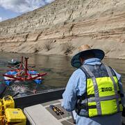
In the spring of 2006, USGS Water Resources Mission Area began a six-month Fiber-Optic Distributed Temperature Sensing (FO-DTS) technology demonstration/evaluation project. As part of this project, several FO-DTS pilot studies were conducted at the 100-meter to kilometer scales. Study goals included evaluating the use of FO-DTS for:
-
mapping submarine groundwater discharge,
-
identifying gaining stream reaches, and
-
identifying transmissive fractures in boreholes.
For each project, additional hydrologic, chemical, or geophysical data were used to help confirm interpretations based on the fiber-optic temperature monitoring results. Since the initial demonstration/evaluation, FO-DTS has been adopted into the USGS hydrogeophysical toolkit and featured prominently in recent groundwater/surface water exchange methods training courses and a number of publications. In 2020, the Water Resources Mission Area published a software graphical user interface (GUI), called DTSGUI, to simplify the processing, analysis, and visualization of FO-DTS data.

About Fiber Optic Distributed Temperature Sensing
FO-DTS measurements involve sending laser light along a fiber-optic cable. Photons interact with the molecular structure of the fibers, and the incident light scatters. Analysis of Raman backscatter for variation in optical power allows the user to estimate temperature. Analysis of Brillouin backscatter for variation in optical frequency allows the user to estimate temperature and strain.
Commercially available FO-DTS technology can achieve:
-
Continuous measurement over many kilometers of cable per instrument channel
-
Spatial resolution of about 0.25 meter along cables (depends on configuration and system), though cables can be wrapped to achieve sub-centimeter resolution
-
Thermal precision of about 0.2 to 0.01 degree Celsius (depends on configuration)
-
Active heating experiments (using specialty cables) for surface water, vadose zone, and borehole data collection
-
Temporal resolution of seconds to hours depending on the desired thermal precision
Spatial, thermal, and temporal resolution are mutually dependent, and depend on measurement configuration.
USGS Water Resources Mission Area projects and science related to FO-DTS methods for groundwater studies.
Geophysics for USGS Groundwater/Surface Water Exchange Studies
Fiber-optic distributed temperature sensing (FO-DTS) technology can be used for characterizing estuary-aquifer and stream-aquifer interaction and for identifying transmissive fractures in bedrock boreholes.
Overview
New geophysical methods are required for monitoring hydrologic processes at the catchment and larger scales, and for quantifying fluxes between groundwater and surface water. Fiber-optic distributed temperature sensing (FO-DTS) is an emerging technology that has promise for characterizing estuary-aquifer and stream-aquifer interaction and for identifying transmissive fractures in bedrock boreholes. Although routinely used for monitoring temperature and (or) strain in petroleum wells, FO-DTS applications in hydrology are uncommon.
Technology Evaluation Project
In the spring of 2006, USGS Water Resources Mission Area began a six-month Fiber-Optic Distributed Temperature Sensing (FO-DTS) technology demonstration/evaluation project. As part of this project, several FO-DTS pilot studies were conducted at the 100-meter to kilometer scales. Study goals included evaluating the use of FO-DTS for:
-
mapping submarine groundwater discharge,
-
identifying gaining stream reaches, and
-
identifying transmissive fractures in boreholes.
For each project, additional hydrologic, chemical, or geophysical data were used to help confirm interpretations based on the fiber-optic temperature monitoring results. Since the initial demonstration/evaluation, FO-DTS has been adopted into the USGS hydrogeophysical toolkit and featured prominently in recent groundwater/surface water exchange methods training courses and a number of publications. In 2020, the Water Resources Mission Area published a software graphical user interface (GUI), called DTSGUI, to simplify the processing, analysis, and visualization of FO-DTS data.
About Fiber Optic Distributed Temperature Sensing
FO-DTS measurements involve sending laser light along a fiber-optic cable. Photons interact with the molecular structure of the fibers, and the incident light scatters. Analysis of Raman backscatter for variation in optical power allows the user to estimate temperature. Analysis of Brillouin backscatter for variation in optical frequency allows the user to estimate temperature and strain.
Commercially available FO-DTS technology can achieve:
-
Continuous measurement over many kilometers of cable per instrument channel
-
Spatial resolution of about 0.25 meter along cables (depends on configuration and system), though cables can be wrapped to achieve sub-centimeter resolution
-
Thermal precision of about 0.2 to 0.01 degree Celsius (depends on configuration)
-
Active heating experiments (using specialty cables) for surface water, vadose zone, and borehole data collection
-
Temporal resolution of seconds to hours depending on the desired thermal precision
Spatial, thermal, and temporal resolution are mutually dependent, and depend on measurement configuration.
USGS Water Resources Mission Area projects and science related to FO-DTS methods for groundwater studies.