
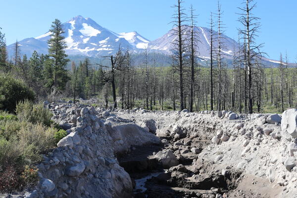
Whitney Creek on the slopes of Mount Shasta in northern California is regularly reshaped by debris flows, created by melting snow and ice or precipitation. Although the stream channel itself is relatively small, these flows are capable of carrying large volumes of volcanic debris, including boulders in excess of several meters. USGS photo by J. Ball.
Jessica L Ball, Ph.D.
I am a physical volcanologist who specializes in volcanic stability and associated hazards, as well as volcanic hazard modeling and communication.
As the Associate Scientist-In-Charge for Hazard Assessment and Communication at the USGS California Volcano Observatory (CalVO), I lead activities at the intersection of hazards research and risk communication. I design, conduct, adapt, and synthesize volcanic hazard research and use forward modeling to forecast and assess societal exposure and vulnerability to adverse events. I translate hazard information to policy makers, civil authorities and the public in order to effectively communicate the importance and relevance of volcanic hazards in the State of California. I entered the USGS as a Mendenhall Postdoctoral Fellow, studying the effects of elevated rock pore pressure on stratovolcano flank stability.
Where I work
At the Clear Lake Volcanic Field, my goals are to unravel the age and progression of maar eruptions, which comprise the youngest eruptive activity in the field. Maars form from steam explosions that occur when magma and water interact, and their craters can be created in single explosions or multiple explosions at the same spot. The ash and rocks thrown up by these maars is present in many places around Clear Lake, particularly around Mount Konocti. If the maars are young enough to have the potential for future eruptions, understanding their dynamics and evolution will be very important for hazard assessment at Clear Lake.
At Mount Shasta, I am using decades of geological mapping, lidar DEMs, and the LaharZ_py model to simulate what would happen if lahars (volcanic mudflows) were to occur as a result of volcanic activity. Lahars are one of the most common hazards on snow-and-ice-capped stratovolcanoes, and while this photo shows that Shasta doesn't always have snow on its flanks, in the wintertime its snow cap can be up to 5 m deep. This would provide ample water to feed lahars that could travel down the volcano's drainages and across its broad, populated lower flanks. By simulating lahars of different sizes and calculating their arrival times, I am creating maps that can be used for planning both in long-term land-use and hazard mitigation, and for response to any lahars that do happen.
As a volcanic hazard communicator, I'm one of the public faces for the USGS Volcano Science Center. I'm a part of the social media team for USGS Volcanoes, which means that I help manage social media feeds and websites, create content for the web, manage outreach activities, and act as a media contact for the California Volcano Observatory. On the past, I've been a part of the media response to the 2018 Kilauea eruption, promoted CalVO and other USGS observatories to policymakers, and represented the USGS in briefings on Capitol Hill. I'm also responsible for building relationships with CalVO's stakeholders, and working with them to make our volcanic hazard products and communications effective.
Science and Products
Whitney Creek, Mount Shasta, California
Whitney Creek on the slopes of Mount Shasta in northern California is regularly reshaped by debris flows, created by melting snow and ice or precipitation. Although the stream channel itself is relatively small, these flows are capable of carrying large volumes of volcanic debris, including boulders in excess of several meters. USGS photo by J. Ball.
Whitney Creek on the slopes of Mount Shasta in northern California is regularly reshaped by debris flows, created by melting snow and ice or precipitation. Although the stream channel itself is relatively small, these flows are capable of carrying large volumes of volcanic debris, including boulders in excess of several meters. USGS photo by J. Ball.
*Disclaimer: Listing outside positions with professional scientific organizations on this Staff Profile are for informational purposes only and do not constitute an endorsement of those professional scientific organizations or their activities by the USGS, Department of the Interior, or U.S. Government