
Schematic map of the Colorado Mineral Belt and constituent geologic features.
Jonathan Caine, Ph.D.
Jonathan Saul Caine is a Research Geologist with the U.S. Geological Survey.
His work is focused on characterization of fault zones, fracture networks, and fluid flow in the Earth’s upper crust. He combines structural geology, hydrogeology, detailed field studies and geologic mapping to characterize fault zone architecture and permeability structure; fault rock textures, deformation mechanisms, and seismogenic signatures of faults and fault rocks; conduct direct fault rock dating; and fault and fracture network related fluid flow as it pertains to mineral deposits, hydrocarbon migration, earthquakes, groundwater supply, environmental geochemistry of hydrothermally altered and complexly deformed crystalline-rock aquifer systems, particularly in alpine watersheds. Caine also works closely with graduate students and colleagues at the University of Colorado (Boulder), Utah State University, Colorado State University, and the Colorado School of Mines. He received his B.A and M.A. in Geology from S.U.N.Y, New Paltz (1986 and 1991) and his Ph.D. in Geology from the University of Utah (1999) with concentration in Structural Geology and Hydrogeology. Caine's work has been conducted in the northeastern Appalachains, the Basin and Range, east Greenland, the southern Rocky Mountains, the Rio Grande rift, Alaska, and Yukon.
Science and Products

Geophysical and Geological Characterization of Mineral Deposit Localization in the Colorado Mineral Belt and Surrounding Lithosphere
The Colorado Mineral Belt (CMB) contains many important metallic and critical mineral deposits, concentrated (or localized) in a region that is geologically complex. The origins of these deposits are still not well understood making the CMB an ideal place to study how geologic processes concentrate minerals. This project aims to determine where, when, and how these mineral deposits form.
Geophysical and Geological Characterization of Mineral Deposit Localization in the Colorado Mineral Belt and Surrounding Lithosphere: Structural Geology
Geologic structures in the Colorado Mineral Belt occur over many scales and include folds, faults, fractures, veins, dikes, foliations, etc. These structures can control the strength and fluid flow properties of rock units and are commonly involved with the formation and localization of mineral deposits.
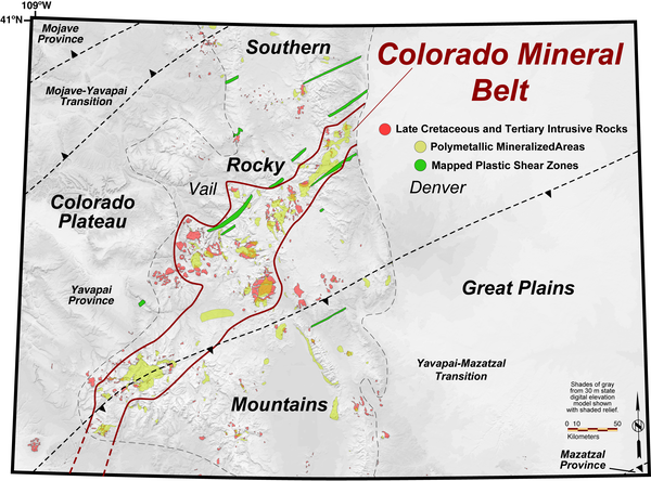
Colorado Mineral Belt location map
Schematic map of the Colorado Mineral Belt and constituent geologic features.
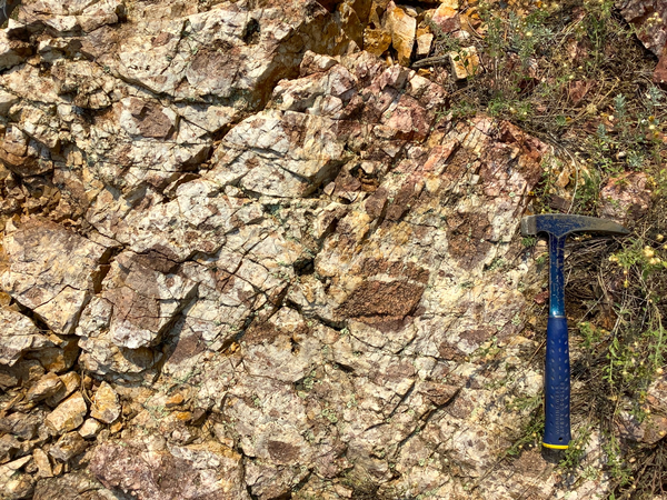
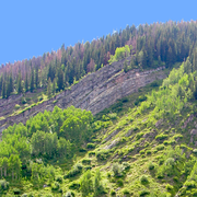
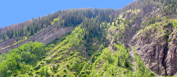
Mineralized Fault Rock Outcrop in Boulder County, Colorado
Mineralized Fault Rock Outcrop in Boulder County, ColoradoOutcrop photo with hammer for scale of the Livingston fault zone which is more resistant to erosion because of brecciation and quartz-based mineralization common in the northeastern Colorado Mineral Belt. Location: Walker Ranch, Boulder County Open Space Park, Colorado.
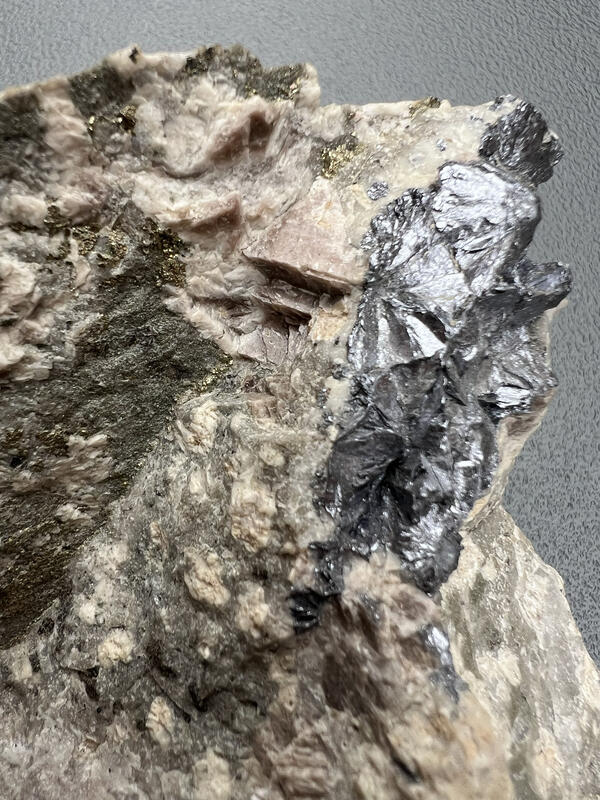
Molybdenite mineralization, Henderson porphyry Mo deposit, Colorado
Molybdenite mineralization, Henderson porphyry Mo deposit, ColoradoMolybdenite mineralization from the Henderson porphyry molybdenum (Mo) deposit associated with quartz and pyrite alteration. The Henderson molybdenum mine is located in Colorado.

Molybdenite mineralization from the Henderson porphyry Mo deposit
Molybdenite mineralization from the Henderson porphyry Mo depositMolybdenite mineralization from the Henderson porphyry Mo deposit in Colorado associated with quartz and pyrite alteration.
Molybdenite mineralization from the Henderson porphyry Mo deposit
Molybdenite mineralization from the Henderson porphyry Mo depositMolybdenite mineralization from the Henderson porphyry Mo deposit in Colorado associated with quartz and pyrite alteration.
Booth Canyon Fold and Fault Zone, East Vail, Colorado
Booth Canyon Fold and Fault Zone, East Vail, ColoradoView west of now tilted (folded), originally horizontal sedimentary beds of the Early Paleozoic Minturn Formation faulted against Early Proterozoic granitic rocks. Booth Canyon, East Vail, Colorado.
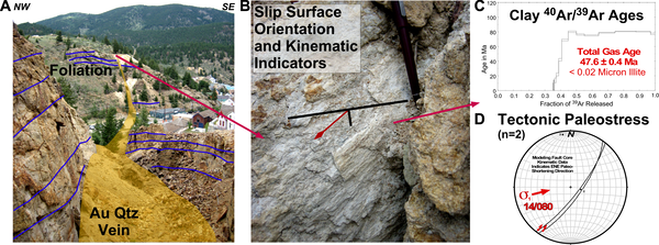
Gregory fault vein and mine with annotations, Colorado
Gregory fault vein and mine with annotations, ColoradoGregory fault vein and mine in Central City, Colorado (photos, annotations, and model by Jonathan Caine, USGS. Also see Caine et al., 2006, 2010). A) The Gregory vein and surrounding clay alteration (yellow) cutting layering in the host rock foliation and layering (blue).

Leave no stone unturned
USGS researcher collecting one more sample while waiting for the helicopter in Kanuti, Alaska. The Kanuti ophiolite is a mafic-ultramafic thrust sheet of probable Jurassic age, formerly considered to be the upper part of the Yukon-Koyukuk ophiolite (Angayucham terrane).
USGS researcher collecting one more sample while waiting for the helicopter in Kanuti, Alaska. The Kanuti ophiolite is a mafic-ultramafic thrust sheet of probable Jurassic age, formerly considered to be the upper part of the Yukon-Koyukuk ophiolite (Angayucham terrane).
Mineralized Fault Rocks in Boulder County, Colorado
Mineralized Fault Rocks in Boulder County, ColoradoView south of the Livingston fault zone which is more resistant to erosion because of brecciation and quartz-based mineralization common in the northeastern Colorado Mineral Belt. Location: Walker Ranch, Boulder County Open Space Park, Colorado.

Three geologists looking at igneous textures in granitic rocks
Three geologists looking at igneous textures in granitic rocksAlaska Science Center geologist Doug Kreiner and University of Alaska, Fairbanks professor Sean Regan look at igneous textures in granitic rocks hosting gold at the Pogo gold mine with Pogo exploration geologists.

Geologists discuss the district-scale geology at Pogo Mine, Alaska
Geologists discuss the district-scale geology at Pogo Mine, AlaskaAlaska Science Center geologist Doug Kreiner and University of Alaska, Fairbanks professor Sean Regan discuss the district-scale geology with the chief exploration geologist at Pogo Mine. This is a new collaborative study with USGS, UAF and Pogo Mine, to collaborate on unraveling the genesis of Pogo, an important producer of gold in Alaska with critical mi
Science and Products
Geophysical and Geological Characterization of Mineral Deposit Localization in the Colorado Mineral Belt and Surrounding Lithosphere
The Colorado Mineral Belt (CMB) contains many important metallic and critical mineral deposits, concentrated (or localized) in a region that is geologically complex. The origins of these deposits are still not well understood making the CMB an ideal place to study how geologic processes concentrate minerals. This project aims to determine where, when, and how these mineral deposits form.
Geophysical and Geological Characterization of Mineral Deposit Localization in the Colorado Mineral Belt and Surrounding Lithosphere: Structural Geology
Geologic structures in the Colorado Mineral Belt occur over many scales and include folds, faults, fractures, veins, dikes, foliations, etc. These structures can control the strength and fluid flow properties of rock units and are commonly involved with the formation and localization of mineral deposits.
Colorado Mineral Belt location map
Schematic map of the Colorado Mineral Belt and constituent geologic features.
Schematic map of the Colorado Mineral Belt and constituent geologic features.
Mineralized Fault Rock Outcrop in Boulder County, Colorado
Mineralized Fault Rock Outcrop in Boulder County, ColoradoOutcrop photo with hammer for scale of the Livingston fault zone which is more resistant to erosion because of brecciation and quartz-based mineralization common in the northeastern Colorado Mineral Belt. Location: Walker Ranch, Boulder County Open Space Park, Colorado.
Molybdenite mineralization, Henderson porphyry Mo deposit, Colorado
Molybdenite mineralization, Henderson porphyry Mo deposit, ColoradoMolybdenite mineralization from the Henderson porphyry molybdenum (Mo) deposit associated with quartz and pyrite alteration. The Henderson molybdenum mine is located in Colorado.
Molybdenite mineralization from the Henderson porphyry Mo deposit
Molybdenite mineralization from the Henderson porphyry Mo depositMolybdenite mineralization from the Henderson porphyry Mo deposit in Colorado associated with quartz and pyrite alteration.
Molybdenite mineralization from the Henderson porphyry Mo deposit
Molybdenite mineralization from the Henderson porphyry Mo depositMolybdenite mineralization from the Henderson porphyry Mo deposit in Colorado associated with quartz and pyrite alteration.
Booth Canyon Fold and Fault Zone, East Vail, Colorado
Booth Canyon Fold and Fault Zone, East Vail, ColoradoView west of now tilted (folded), originally horizontal sedimentary beds of the Early Paleozoic Minturn Formation faulted against Early Proterozoic granitic rocks. Booth Canyon, East Vail, Colorado.
Gregory fault vein and mine with annotations, Colorado
Gregory fault vein and mine with annotations, ColoradoGregory fault vein and mine in Central City, Colorado (photos, annotations, and model by Jonathan Caine, USGS. Also see Caine et al., 2006, 2010). A) The Gregory vein and surrounding clay alteration (yellow) cutting layering in the host rock foliation and layering (blue).
Leave no stone unturned
USGS researcher collecting one more sample while waiting for the helicopter in Kanuti, Alaska. The Kanuti ophiolite is a mafic-ultramafic thrust sheet of probable Jurassic age, formerly considered to be the upper part of the Yukon-Koyukuk ophiolite (Angayucham terrane).
USGS researcher collecting one more sample while waiting for the helicopter in Kanuti, Alaska. The Kanuti ophiolite is a mafic-ultramafic thrust sheet of probable Jurassic age, formerly considered to be the upper part of the Yukon-Koyukuk ophiolite (Angayucham terrane).
Mineralized Fault Rocks in Boulder County, Colorado
Mineralized Fault Rocks in Boulder County, ColoradoView south of the Livingston fault zone which is more resistant to erosion because of brecciation and quartz-based mineralization common in the northeastern Colorado Mineral Belt. Location: Walker Ranch, Boulder County Open Space Park, Colorado.
Mineralized Fault Rocks in Boulder County, Colorado
Mineralized Fault Rocks in Boulder County, ColoradoView south of the Livingston fault zone which is more resistant to erosion because of brecciation and quartz-based mineralization common in the northeastern Colorado Mineral Belt. Location: Walker Ranch, Boulder County Open Space Park, Colorado.
Three geologists looking at igneous textures in granitic rocks
Three geologists looking at igneous textures in granitic rocksAlaska Science Center geologist Doug Kreiner and University of Alaska, Fairbanks professor Sean Regan look at igneous textures in granitic rocks hosting gold at the Pogo gold mine with Pogo exploration geologists.
Geologists discuss the district-scale geology at Pogo Mine, Alaska
Geologists discuss the district-scale geology at Pogo Mine, AlaskaAlaska Science Center geologist Doug Kreiner and University of Alaska, Fairbanks professor Sean Regan discuss the district-scale geology with the chief exploration geologist at Pogo Mine. This is a new collaborative study with USGS, UAF and Pogo Mine, to collaborate on unraveling the genesis of Pogo, an important producer of gold in Alaska with critical mi