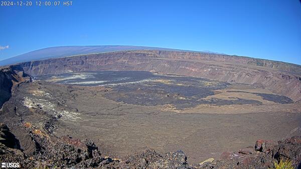
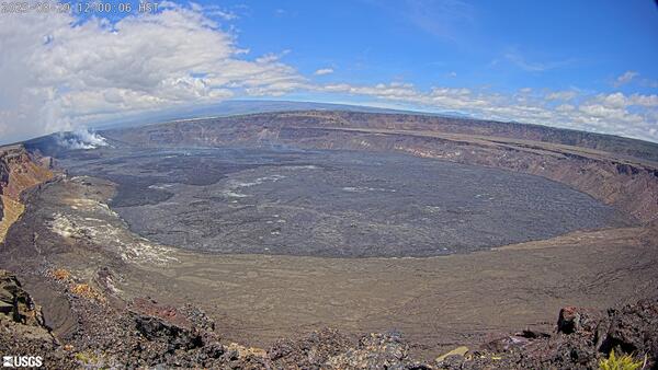
I am a geologist with the Hawaiian Volcano Observatory, conducting research and monitoring of active eruptions.
Professional Experience
US Geological Survey - Hawaiian Volcano Observatory: Research Geologist, 2007-present
Michigan Tech University: Postdoctoral Researcher, 2006-2007
University of Hawaii Manoa: Postdoctoral Researcher, 2005-2006
Education and Certifications
University of Hawai‘i Mānoa Geology 8/02 – 8/05 Ph.D. 2005
University of Alaska Fairbanks Geology 8/99 – 5/02 M.S. 2002
Cornell University Geology 8/95 – 5/99 B.S. 1999
Science and Products
Photogrammetry-derived digital elevation models and source images for an inactive perched lava lake formed at Pu‘u‘ō‘ō (Kīlauea) in 2014
Lava flow hazards are usually thought to end when the erupting vent becomes inactive, but this is not always the case. At Kīlauea in August 2014, a spiny ʻaʻā flow erupted from the levee of a crusted perched lava lake that had been inactive for a month, and the surface of the lava lake subsided as the flow advanced downslope over the following few days. Topography constructed from oblique aerial p
Thermal camera data for the summit of Kīlauea Volcano, 2019–2022
Following the 2018 collapses of the caldera floor at the summit of Kīlauea Volcano (Anderson and others, 2019; Neal and others, 2019), the enlarged and deepened depression hosted a variety of volcanic activity between 2019 and 2022. These events included an unprecedented water lake and two prolonged episodes of lava lake activity. This data release includes images from a stationary thermal camer
Elevation of the lava lake in Halemaʻumaʻu crater, Kīlauea Volcano, from 2009 to 2018
This data release includes measurements of the surface elevation of the lava lake within Halemaʻumaʻu crater, at the summit of Kīlauea Volcano, during the 2008-2018 summit eruption (Patrick and others, 2021). The data were measured by several instruments (laser rangefinder, webcams, lidar) and are compiled here to provide the most complete dataset yet available on the elevation of Kīlauea’s 2008-
Colorimeter data for the summit water lake at Kīlauea Volcano, Island of Hawaiʻi, 2020
In 2018, a large effusive eruption on the lower flank of Kīlauea Volcano was associated with collapse and subsidence of the summit caldera floor (Neal and others, 2019). The bottom of Halemaʻumaʻu, a crater nested within the summit caldera, subsided by more than 500 m. In July 2019, water was observed ponding on the deepest part of the Halemaʻumaʻu crater floor and the water rose and enlarged in
Sample details and near-real-time ED-XRF, grain size, and grain shape data collected during the November – December 2022 eruption of Mauna Loa volcano, Island of Hawaiʻi
At 11:21 p.m. (Hawaii Standard Time [HST]) on November 27, 2022, Mauna Loa volcano on the Island of Hawaiʻi started erupting from fissures at its summit caldera, Mokuʻāweoweo. This was followed shortly afterwards by the opening of a segment of fissures in the direction of the Southwest Rift Zone. These were mostly within the structural boundary of the caldera, so their location is denoted as ‘Sout
Rapid-response digital elevation models of the 2020-present summit eruptions at Kilauea Volcano, Island of Hawai'i
We depict changing eruptive features within the summit caldera of Kilauea volcano, Island of Hawai'i with rapid-response digital elevation models (DEMs) acquired since a series of caldera-filling effusive eruptions began on December 20, 2020. These eruptions follow the caldera collapse of 2018, with new lava progressively filling the approximately 1-cubic-kilometer pit that formed between May and
Water-level data for the crater lake at the summit of Kilauea Volcano, Island of Hawai'i, 2019-2020
During 2018, Kilauea Volcano, on the Island of Hawaiii, had a large effusive eruption (~1 cubic kilometer of lava) on the lower East Rift Zone that caused widespread destruction (Neal and others, 2019; Dietterich and others, 2021). This lower flank eruption was accompanied by one of the largest collapses of the summit caldera in two hundred years, with portions of the caldera floor subsiding more
Crater geometry data for Puʻuʻōʻō, on Kīlauea Volcano’s East Rift Zone, in May 2018
The 2018 lower East Rift Zone eruption and accompanying summit collapse of Kīlauea Volcano, Hawaiʻi, comprised one of the most impactful events on the volcano in the past 200 years, with hundreds of homes destroyed and major changes in the topography of the summit caldera. The opening stages of this eruptive sequence started on 30 April, when a magmatic dike began moving east from Puʻuʻōʻō, a con
Volcanic plume heights from the summit of Kilauea Volcano, Hawai'i
This data release provides volcanic plume heights from the summit of Kilauea Volcano for 2008-2015, and during the eruptive events of 2018. For 2018, a Secacam Wild Vision Full HD camera with a 7mm focal length was located at 1717 m elevation approximately 15 m south of the Mauna Loa Strip Road within Hawai'i Volcanoes National Park, 19.475843degreesN, 155.363560degreesW (WGS84). The camera was po
Lava level and crater geometry data during the 2018 lava lake draining at Kilauea Volcano, Hawaii
In May 2018, the onset of new eruptive activity on the lower flank of Kīlauea Volcano, Hawaiʻi, accompanied the draining of the lava lake at the summit, 40 km upslope. The lava lake draining lasted over seven days, and transitioned into the largest collapse event at the summit of Kīlauea in over 200 years, with the paired flank and summit activity marking a historic episode in the modern record of
Cyclic lava effusion during the 2018 eruption of Kilauea Volcano: data release
This USGS data release includes data related to the Science magazine manuscript "Cyclic lava effusion during the 2018 eruption of Kilauea Volcano" by Patrick et al. The data release includes 1) original video as well as thermal, and timelapse images of lava in the proximal Fissure 8 channel, 2) derived estimates of lava level in the channel and bulk effusion rates (not corrected for vesicles), 3)
GIS shapefiles for the June 27th lava flow at Kilauea volcano, Hawaii, June 2014-June 2016
This dataset contains shapefiles and associated metadata showing evolution of the "June 27th" lava flow (Pu?u ???? eruptive episode 61e) that was active at Kilauea volcano from June 27, 2014, to June 8, 2016. The dataset contains (1) an attributed polyline shapefile and (2) an attributed polygon shapefile with features that represent the outline and extent of the flow on 35 different dates. The da
Filter Total Items: 61
Eruption of stagnant lava from an inactive perched lava lake
Lava flow hazards are usually thought to end when the erupting vent becomes inactive, but this is not always the case. At Kīlauea in August 2014, a spiny ʻaʻā flow erupted from the levee of a crusted perched lava lake that had been inactive for a month, and the surface of the lava lake subsided as the flow advanced downslope over the following few days. Topography constructed from oblique aerial p
Authors
T. Orr, Michael H. Zoeller, Edward W. Llewellin, Matthew R. Patrick
The 2018 eruption of Kīlauea: Insights, puzzles, and opportunities for volcano science
The science of volcanology advances disproportionately during exceptionally large or well-observed eruptions. The 2018 eruption of Kīlauea Volcano (Hawai‘i) was its most impactful in centuries, involving an outpouring of more than one cubic kilometer of basalt, a magnitude 7 flank earthquake, and the volcano’s largest summit collapse since at least the nineteenth century. Eruptive activity was doc
Authors
Kyle R. Anderson, Tom Shea, Kendra J. Lynn, Emily Montgomery-Brown, Donald A. Swanson, Matthew R. Patrick, Brian Shiro, Christina A. Neal
Toward next-generation lava flow forecasting: Development of a fast, physics-based lava propagation model
During effusive volcanic crises, the eruption and propagation of lava flows pose a significant hazard to nearby populations, homes, and infrastructure. Consequently, timely lava flow forecasts are a critical need for volcano observatory and emergency management operations. Previous lava flow modeling tools are typically either too slow to produce timely forecasts, or are fast, but lack critical as
Authors
David M.R. Hyman, Hannah R. Dietterich, Matthew R. Patrick
Development, structure, and behavior of a perched lava channel at Kīlauea Volcano, Hawaiʻi, during 2007
Channelized lava flows are commonly produced during the early stages of basaltic eruptions. These channels usually maintain their morphology until the eruption ends or discharge is diverted. In some instances, narrower channels can roof over, developing into lava tubes. We report here on a channelized flow erupted at Kīlauea volcano in 2007 that evolved into a “perched lava channel” composed of a
Authors
T. Orr, Edward W. Llewellin, Matthew R. Patrick
Damage assessment for the 2018 lower East Rift Zone lava flows of Kīlauea volcano, Hawaiʻi
Cataloguing damage and its correlation with hazard intensity is one of the key components needed to robustly assess future risk and plan for mitigation as it provides important empirical data. Damage assessments following volcanic eruptions have been conducted for buildings and other structures following hazards such as tephra fall, pyroclastic density currents, and lahars. However, there are rela
Authors
Elinor S. Meredith, Susanna F. Jenkins, Josh L. Hayes, Natalia Irma Deligne, David Lallemant, Matthew R. Patrick, Christina A. Neal
Rainfall an unlikely trigger of Kilauea’s 2018 rift eruption
If volcanic eruptions could be forecast from the occurrence of some external process, it might be possible to better mitigate risk and protect lives and livelihoods. Farquharson and Amelung1 suggested that the 2018 lower East Rift Zone (ERZ) eruption of Kīlauea Volcano—the most destructive eruption in Hawai‘i in at least 200 years2—was triggered by extreme precipitation, which caused increased por
Authors
M. Poland, Shaul Hurwitz, James P. Kauahikaua, Emily Montgomery-Brown, Kyle R. Anderson, Ingrid Johanson, Matthew R. Patrick, Christina A. Neal
Crater growth and lava-lake dynamics revealed through multitemporal terrestrial lidar scanning at Kīlauea Volcano, Hawaiʻi
Lava lake surfaces display the tops of active magma columns and respond to eruption variables such as magmatic pressure, convection, degassing, and cooling, as well as interactions with the craters that contain them. However, they are challenging to study owing to the numerous hazards that accompany these eruptions, and they are typically difficult to observe because the emitted gas plumes obscure
Authors
Adam L. LeWinter, Steve W. Anderson, David C. Finnegan, Matthew R. Patrick, Tim R. Orr
Evaluating lava flow propagation models with a case study from the 2018 eruption of Kīlauea Volcano, Hawai'i
The 2018 lower East Rift Zone (LERZ) eruption of Kīlauea, Hawai’i, provides an excellent natural laboratory with which to test models of lava flow propagation. During early stages of eruption crises, the most useful lava flow propagation equations utilize readily determined parameters and require fewer a priori assumptions about future behavior of the flow. Here, we leverage the numerous observati
Authors
Rebecca deGraffenried, Julia E. Hammer, Hannah R. Dietterich, Ryan L. Perroy, Matthew R. Patrick, Thomas Shea
High-speed lava flow infrasound from Kīlauea’s fissure 8 and its utility in monitoring effusion rate
The 2018 eruption of Kīlauea Volcano produced large and destructive lava flows from the fissure 8 (Ahu ‘aila ‘au) vent with flow velocities up to 17 m s−1, highly variable effusion rates over both short (minutes) and long (hours) time scales, and a proximal channel or spillway that displayed flow features similar to open channel flow in river systems. Monitoring such dynamic vent and lava flow sys
Authors
John J. Lyons, Hannah R. Dietterich, Matthew R. Patrick, David Fee
Onset and evolution of Kilauea’s 2018 flank eruption and summit collapse from continuous gravity
Prior to the 2018 lower East Rift Zone (ERZ) eruption and summit collapse of Kīlauea Volcano, Hawai‘i, continuous gravimeters operated on the vent rims of ongoing eruptions at both the summit and Pu‘u ‘Ō‘ō. These instruments captured the onset of the 2018 lower ERZ eruption and the effects of lava withdrawal from both locales, providing constraints on the timing and style of activity and the physi
Authors
M. Poland, Daniele Carbone, Matthew R. Patrick
Brittle fragmentation by rapid gas separation in a Hawaiian fountain
Brittle fragmentation, generating small pyroclasts from magma, is a key process determining eruptive style. How low-viscosity magma fragments within a rising fountain in a brittle manner, however, is not well understood. Here we describe a fragmentation process in Hawaiian fountains on the basis of observations from the 2018 lower East Rift Zone eruption of Kīlauea Volcano, Hawai’i. The dominant f
Authors
Atsuko Namiki, Matthew R. Patrick, Michael Manga, Bruce F. Houghton
Lava effusion rate evolution and erupted volume during the 2018 Kīlauea lower East Rift Zone eruption
The 2018 eruption on the lower East Rift Zone of Kīlauea Volcano produced one of the largest and most destructive lava flows in Hawai’i during the past 200 years. Over the course of more than 3 months, twenty-four fissures erupted, and the rate of lava effusion varied by two orders of magnitude, with significant implications for evolving flow behavior and hazards. Syn-eruptive data were collected
Authors
Hannah R. Dietterich, Angela K. Diefenbach, Adam Soule, Michael H. Zoeller, Matthew R. Patrick, J. J. Major, Paul Lundgren
Science and Products
- Data
Photogrammetry-derived digital elevation models and source images for an inactive perched lava lake formed at Pu‘u‘ō‘ō (Kīlauea) in 2014
Lava flow hazards are usually thought to end when the erupting vent becomes inactive, but this is not always the case. At Kīlauea in August 2014, a spiny ʻaʻā flow erupted from the levee of a crusted perched lava lake that had been inactive for a month, and the surface of the lava lake subsided as the flow advanced downslope over the following few days. Topography constructed from oblique aerial pThermal camera data for the summit of Kīlauea Volcano, 2019–2022
Following the 2018 collapses of the caldera floor at the summit of Kīlauea Volcano (Anderson and others, 2019; Neal and others, 2019), the enlarged and deepened depression hosted a variety of volcanic activity between 2019 and 2022. These events included an unprecedented water lake and two prolonged episodes of lava lake activity. This data release includes images from a stationary thermal camerElevation of the lava lake in Halemaʻumaʻu crater, Kīlauea Volcano, from 2009 to 2018
This data release includes measurements of the surface elevation of the lava lake within Halemaʻumaʻu crater, at the summit of Kīlauea Volcano, during the 2008-2018 summit eruption (Patrick and others, 2021). The data were measured by several instruments (laser rangefinder, webcams, lidar) and are compiled here to provide the most complete dataset yet available on the elevation of Kīlauea’s 2008-Colorimeter data for the summit water lake at Kīlauea Volcano, Island of Hawaiʻi, 2020
In 2018, a large effusive eruption on the lower flank of Kīlauea Volcano was associated with collapse and subsidence of the summit caldera floor (Neal and others, 2019). The bottom of Halemaʻumaʻu, a crater nested within the summit caldera, subsided by more than 500 m. In July 2019, water was observed ponding on the deepest part of the Halemaʻumaʻu crater floor and the water rose and enlarged inSample details and near-real-time ED-XRF, grain size, and grain shape data collected during the November – December 2022 eruption of Mauna Loa volcano, Island of Hawaiʻi
At 11:21 p.m. (Hawaii Standard Time [HST]) on November 27, 2022, Mauna Loa volcano on the Island of Hawaiʻi started erupting from fissures at its summit caldera, Mokuʻāweoweo. This was followed shortly afterwards by the opening of a segment of fissures in the direction of the Southwest Rift Zone. These were mostly within the structural boundary of the caldera, so their location is denoted as ‘SoutRapid-response digital elevation models of the 2020-present summit eruptions at Kilauea Volcano, Island of Hawai'i
We depict changing eruptive features within the summit caldera of Kilauea volcano, Island of Hawai'i with rapid-response digital elevation models (DEMs) acquired since a series of caldera-filling effusive eruptions began on December 20, 2020. These eruptions follow the caldera collapse of 2018, with new lava progressively filling the approximately 1-cubic-kilometer pit that formed between May andWater-level data for the crater lake at the summit of Kilauea Volcano, Island of Hawai'i, 2019-2020
During 2018, Kilauea Volcano, on the Island of Hawaiii, had a large effusive eruption (~1 cubic kilometer of lava) on the lower East Rift Zone that caused widespread destruction (Neal and others, 2019; Dietterich and others, 2021). This lower flank eruption was accompanied by one of the largest collapses of the summit caldera in two hundred years, with portions of the caldera floor subsiding moreCrater geometry data for Puʻuʻōʻō, on Kīlauea Volcano’s East Rift Zone, in May 2018
The 2018 lower East Rift Zone eruption and accompanying summit collapse of Kīlauea Volcano, Hawaiʻi, comprised one of the most impactful events on the volcano in the past 200 years, with hundreds of homes destroyed and major changes in the topography of the summit caldera. The opening stages of this eruptive sequence started on 30 April, when a magmatic dike began moving east from Puʻuʻōʻō, a conVolcanic plume heights from the summit of Kilauea Volcano, Hawai'i
This data release provides volcanic plume heights from the summit of Kilauea Volcano for 2008-2015, and during the eruptive events of 2018. For 2018, a Secacam Wild Vision Full HD camera with a 7mm focal length was located at 1717 m elevation approximately 15 m south of the Mauna Loa Strip Road within Hawai'i Volcanoes National Park, 19.475843degreesN, 155.363560degreesW (WGS84). The camera was poLava level and crater geometry data during the 2018 lava lake draining at Kilauea Volcano, Hawaii
In May 2018, the onset of new eruptive activity on the lower flank of Kīlauea Volcano, Hawaiʻi, accompanied the draining of the lava lake at the summit, 40 km upslope. The lava lake draining lasted over seven days, and transitioned into the largest collapse event at the summit of Kīlauea in over 200 years, with the paired flank and summit activity marking a historic episode in the modern record ofCyclic lava effusion during the 2018 eruption of Kilauea Volcano: data release
This USGS data release includes data related to the Science magazine manuscript "Cyclic lava effusion during the 2018 eruption of Kilauea Volcano" by Patrick et al. The data release includes 1) original video as well as thermal, and timelapse images of lava in the proximal Fissure 8 channel, 2) derived estimates of lava level in the channel and bulk effusion rates (not corrected for vesicles), 3)GIS shapefiles for the June 27th lava flow at Kilauea volcano, Hawaii, June 2014-June 2016
This dataset contains shapefiles and associated metadata showing evolution of the "June 27th" lava flow (Pu?u ???? eruptive episode 61e) that was active at Kilauea volcano from June 27, 2014, to June 8, 2016. The dataset contains (1) an attributed polyline shapefile and (2) an attributed polygon shapefile with features that represent the outline and extent of the flow on 35 different dates. The da - Multimedia
- Publications
Filter Total Items: 61
Eruption of stagnant lava from an inactive perched lava lake
Lava flow hazards are usually thought to end when the erupting vent becomes inactive, but this is not always the case. At Kīlauea in August 2014, a spiny ʻaʻā flow erupted from the levee of a crusted perched lava lake that had been inactive for a month, and the surface of the lava lake subsided as the flow advanced downslope over the following few days. Topography constructed from oblique aerial pAuthorsT. Orr, Michael H. Zoeller, Edward W. Llewellin, Matthew R. PatrickThe 2018 eruption of Kīlauea: Insights, puzzles, and opportunities for volcano science
The science of volcanology advances disproportionately during exceptionally large or well-observed eruptions. The 2018 eruption of Kīlauea Volcano (Hawai‘i) was its most impactful in centuries, involving an outpouring of more than one cubic kilometer of basalt, a magnitude 7 flank earthquake, and the volcano’s largest summit collapse since at least the nineteenth century. Eruptive activity was docAuthorsKyle R. Anderson, Tom Shea, Kendra J. Lynn, Emily Montgomery-Brown, Donald A. Swanson, Matthew R. Patrick, Brian Shiro, Christina A. NealToward next-generation lava flow forecasting: Development of a fast, physics-based lava propagation model
During effusive volcanic crises, the eruption and propagation of lava flows pose a significant hazard to nearby populations, homes, and infrastructure. Consequently, timely lava flow forecasts are a critical need for volcano observatory and emergency management operations. Previous lava flow modeling tools are typically either too slow to produce timely forecasts, or are fast, but lack critical asAuthorsDavid M.R. Hyman, Hannah R. Dietterich, Matthew R. PatrickDevelopment, structure, and behavior of a perched lava channel at Kīlauea Volcano, Hawaiʻi, during 2007
Channelized lava flows are commonly produced during the early stages of basaltic eruptions. These channels usually maintain their morphology until the eruption ends or discharge is diverted. In some instances, narrower channels can roof over, developing into lava tubes. We report here on a channelized flow erupted at Kīlauea volcano in 2007 that evolved into a “perched lava channel” composed of aAuthorsT. Orr, Edward W. Llewellin, Matthew R. PatrickDamage assessment for the 2018 lower East Rift Zone lava flows of Kīlauea volcano, Hawaiʻi
Cataloguing damage and its correlation with hazard intensity is one of the key components needed to robustly assess future risk and plan for mitigation as it provides important empirical data. Damage assessments following volcanic eruptions have been conducted for buildings and other structures following hazards such as tephra fall, pyroclastic density currents, and lahars. However, there are relaAuthorsElinor S. Meredith, Susanna F. Jenkins, Josh L. Hayes, Natalia Irma Deligne, David Lallemant, Matthew R. Patrick, Christina A. NealRainfall an unlikely trigger of Kilauea’s 2018 rift eruption
If volcanic eruptions could be forecast from the occurrence of some external process, it might be possible to better mitigate risk and protect lives and livelihoods. Farquharson and Amelung1 suggested that the 2018 lower East Rift Zone (ERZ) eruption of Kīlauea Volcano—the most destructive eruption in Hawai‘i in at least 200 years2—was triggered by extreme precipitation, which caused increased porAuthorsM. Poland, Shaul Hurwitz, James P. Kauahikaua, Emily Montgomery-Brown, Kyle R. Anderson, Ingrid Johanson, Matthew R. Patrick, Christina A. NealCrater growth and lava-lake dynamics revealed through multitemporal terrestrial lidar scanning at Kīlauea Volcano, Hawaiʻi
Lava lake surfaces display the tops of active magma columns and respond to eruption variables such as magmatic pressure, convection, degassing, and cooling, as well as interactions with the craters that contain them. However, they are challenging to study owing to the numerous hazards that accompany these eruptions, and they are typically difficult to observe because the emitted gas plumes obscureAuthorsAdam L. LeWinter, Steve W. Anderson, David C. Finnegan, Matthew R. Patrick, Tim R. OrrEvaluating lava flow propagation models with a case study from the 2018 eruption of Kīlauea Volcano, Hawai'i
The 2018 lower East Rift Zone (LERZ) eruption of Kīlauea, Hawai’i, provides an excellent natural laboratory with which to test models of lava flow propagation. During early stages of eruption crises, the most useful lava flow propagation equations utilize readily determined parameters and require fewer a priori assumptions about future behavior of the flow. Here, we leverage the numerous observatiAuthorsRebecca deGraffenried, Julia E. Hammer, Hannah R. Dietterich, Ryan L. Perroy, Matthew R. Patrick, Thomas SheaHigh-speed lava flow infrasound from Kīlauea’s fissure 8 and its utility in monitoring effusion rate
The 2018 eruption of Kīlauea Volcano produced large and destructive lava flows from the fissure 8 (Ahu ‘aila ‘au) vent with flow velocities up to 17 m s−1, highly variable effusion rates over both short (minutes) and long (hours) time scales, and a proximal channel or spillway that displayed flow features similar to open channel flow in river systems. Monitoring such dynamic vent and lava flow sysAuthorsJohn J. Lyons, Hannah R. Dietterich, Matthew R. Patrick, David FeeOnset and evolution of Kilauea’s 2018 flank eruption and summit collapse from continuous gravity
Prior to the 2018 lower East Rift Zone (ERZ) eruption and summit collapse of Kīlauea Volcano, Hawai‘i, continuous gravimeters operated on the vent rims of ongoing eruptions at both the summit and Pu‘u ‘Ō‘ō. These instruments captured the onset of the 2018 lower ERZ eruption and the effects of lava withdrawal from both locales, providing constraints on the timing and style of activity and the physiAuthorsM. Poland, Daniele Carbone, Matthew R. PatrickBrittle fragmentation by rapid gas separation in a Hawaiian fountain
Brittle fragmentation, generating small pyroclasts from magma, is a key process determining eruptive style. How low-viscosity magma fragments within a rising fountain in a brittle manner, however, is not well understood. Here we describe a fragmentation process in Hawaiian fountains on the basis of observations from the 2018 lower East Rift Zone eruption of Kīlauea Volcano, Hawai’i. The dominant fAuthorsAtsuko Namiki, Matthew R. Patrick, Michael Manga, Bruce F. HoughtonLava effusion rate evolution and erupted volume during the 2018 Kīlauea lower East Rift Zone eruption
The 2018 eruption on the lower East Rift Zone of Kīlauea Volcano produced one of the largest and most destructive lava flows in Hawai’i during the past 200 years. Over the course of more than 3 months, twenty-four fissures erupted, and the rate of lava effusion varied by two orders of magnitude, with significant implications for evolving flow behavior and hazards. Syn-eruptive data were collectedAuthorsHannah R. Dietterich, Angela K. Diefenbach, Adam Soule, Michael H. Zoeller, Matthew R. Patrick, J. J. Major, Paul Lundgren - News