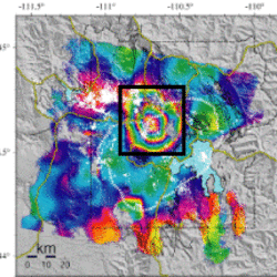
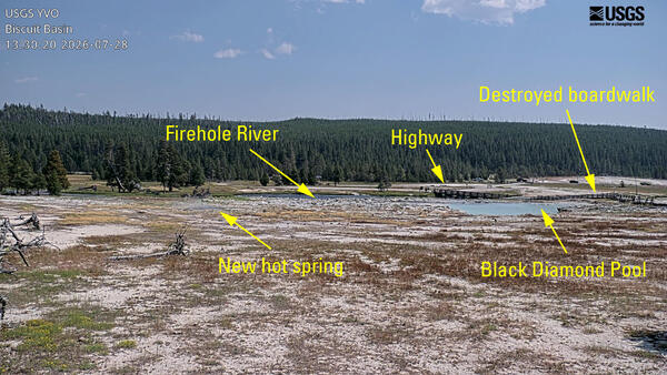
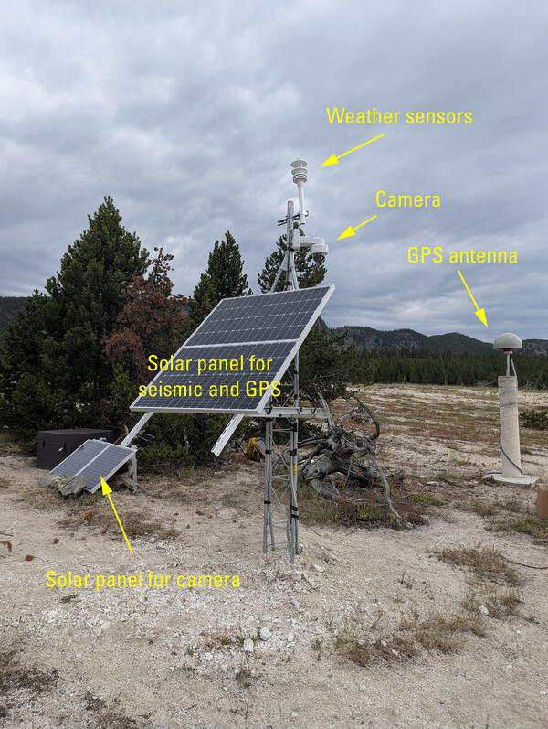
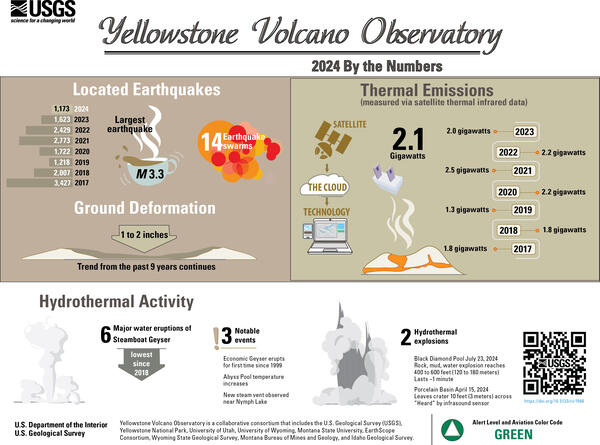
Mike Poland is a research geophysicist with the Cascades Volcano Observatory and the current Scientist-in-Charge of the Yellowstone Volcano Observatory.
Mike's area of specialization is volcano geodesy, which emphasizes the surface deformation and gravity fields associated with volcanic activity. This work involves the use of space-based technologies, like Interferometric Synthetic Aperture Radar (InSAR), as well as ground-based techniques, like microgravity surveys. Mike has taken part in studies on a variety of volcanic systems in the United States, including Mount St. Helens and other volcanoes of the Pacific Northwest, Kilauea and Mauna Loa volcanoes in Hawaii, and the Yellowstone caldera. His recent work has focused on using gravity change over time to understand the character of the fluids that drive volcanic unrest, and also on the potential of satellite data to improve forecasts of future changes in volcanic activity.
Professional Experience
U.S. Geological Survey - Yellowstone Volcano Observatory: Scientist-in-Charge (2017 - present)
U.S. Geological Survey – Cascades Volcano Observatory: Research Geophysicist (2015 - present)
U.S. Geological Survey – Hawaiian Volcano Observatory: Research Geophysicist (2005 - 2015)
U.S. Geological Survey – Cascades Volcano Observatory: Research Geophysicist (2002 - 2005)
Department of Geology, Clark College (Vancouver, Washington): Instructor (2004)
Arizona State University, Department of Geological Sciences: Graduate Teaching/Research Assoc. (1997 - 2001)
Education and Certifications
Arizona State University: Ph.D. (2001), Geological Sciences
University of California, Davis: B.S. (1997), Geology
Affiliations and Memberships*
American Geophysical Union (AGU)
Geological Society of America (GSA)
International Association of Volcanology and Chemistry of the Earth's Interior (IAVCEI)
Honors and Awards
Fellow, Geological Society of America, 2021
Science and Products
Optimizing satellite resources for the global assessment and mitigation of volcanic hazards
Data of the Hawaiian Volcano Observatory (HVO) Kīlauea Campaign Gravity Network (KCGN)
Continuous gravity data from K?lauea Volcano, Hawai?i
Repeat microgravity data from Yellowstone National Park, Wyoming
Lessons learned from the 2022 CONVERSE Monogenetic Volcanism Response Scenario exercise
Microgravity as a tool for eruption forecasting
High-resolution InSAR reveals localized pre-eruptive deformation inside the crater of Agung Volcano, Indonesia
Officially social: Developing a social media crisis communication strategy for USGS Volcanoes during the 2018 Kīlauea eruption
Rapid pre-explosion increase in dome extrusion rate at La Soufrière, St. Vincent quantified from synthetic aperture radar backscatter
Optimizing satellite resources for the global assessment and mitigation of volcanic hazards—Suggestions from the USGS Powell Center Volcano Remote Sensing Working Group
Microgravity change during the 2008-2018 Kı̄lauea summit eruption: Nearly a decade of subsurface mass accumulation
The centenary of IAVCEI 1919–2019 and beyond: The people, places, and things of volcano geodesy
Synthetic aperture radar volcanic flow maps (SAR VFMs): A simple method for rapid identification and mapping of volcanic mass flows
Volcano geodesy using InSAR in 2020: The past and next decades
Rainfall an unlikely trigger of Kilauea’s 2018 rift eruption
A decade of geodetic change at Kīlauea’s summit—Observations, interpretations, and unanswered questions from studies of the 2008–2018 Halemaʻumaʻu eruption
Science and Products
- Science
Optimizing satellite resources for the global assessment and mitigation of volcanic hazards
A vast number of the world’s volcanoes are unmonitored by ground-based sensors, yet constitute an important hazard to nearby residents and infrastructure, as well as air travel and the global economy. Satellite data provide a cost-effective means of tracking activity at such volcanoes. Unfortunately, satellite acquisitions are not optimized for application to volcano hazards, in part because cle - Data
Data of the Hawaiian Volcano Observatory (HVO) Kīlauea Campaign Gravity Network (KCGN)
Data Description Campaign microgravity surveys have been conducted at K?lauea, Hawai‘i (USA), since 1975 (Dzurisin and others, 1980) and, when combined with deformation measurements, enable insights into mass change within the volcano (Jachens and Eaton, 1980; Johnson, 1992; Kauahikaua and Miklius, 2003; Johnson and others, 2010; Bagnardi and others, 2014; Poland and others 2019). For example, micContinuous gravity data from K?lauea Volcano, Hawai?i
This Data Release contains continuous gravity records from two instruments on Kilauea Volcano, Hawaiʻ'i the HOVL gravimeter, located on the east rim of Halema'uma'u Crater directly above the 2008-2018 summit eruptive vent, and the PUOC gravimeter, located on northern rim of Puu Oo crater on Kīlauea's East Rift Zone. Both instruments were collocated with GNSS stations. The HOVL gravimeter was instaRepeat microgravity data from Yellowstone National Park, Wyoming
These data are microgravity measurements collected in Yellowstone National Park. Data are collected using multiple instruments, which each data file representing measurements from a specific instrument during a specific time period. The data dictionary explains the file format and contents, and the dataset will be updated as new data are collected. - Multimedia
- Publications
Filter Total Items: 146
Lessons learned from the 2022 CONVERSE Monogenetic Volcanism Response Scenario exercise
When volcanic unrest occurs, the scientific community can advance fundamental understanding of volcanic systems, but only with coordination before, during, and after the event across academic and governmental agencies. To develop a coordinated response plan, the Community Network for Volcanic Eruption Response (CONVERSE) orchestrated a scenario exercise centered around a hypothetical volcanic crisAuthorsYolanda C Lin, Einat Lev, Ria Mukerji, Tobias P. Fischer, Charles Connor, Wendy K. Stovall, M. Poland, Alexandra M. Iezzi, Christelle Wauthier, Judit Gonzalez-Santana, Heather M. Wright, Samantha Wolf, Tobi KasaliMicrogravity as a tool for eruption forecasting
Detection of gravity change over time has been used to better understand magmatic activity at volcanoes for decades, but the technique is not commonly applied to forecasting eruptions. In contrast, other tools, notably seismic, deformation, and gas monitoring have made exceptional strides in the past several decades and form the foundation for eruption forecasting, especially during the final builAuthorsElske de Zeeuw-van Dalfsen, Michael P. PolandHigh-resolution InSAR reveals localized pre-eruptive deformation inside the crater of Agung Volcano, Indonesia
During a volcanic crisis, high-rate, localized deformation can indicate magma close to the surface, with important implications for eruption forecasting. However, only a few such examples have been reported, because frequent, dense monitoring is needed. High-resolution Synthetic Aperture Radar (SAR) is capable of achieving <1 m spatial resolution and sub-weekly revisit times, but is under-used. HeAuthorsMark Bemelmans, Juliet Biggs, Michael P. Poland, James Wookey, Susanna Ebmeier, Angela K. Diefenbach, Devy Damil SyahbanaOfficially social: Developing a social media crisis communication strategy for USGS Volcanoes during the 2018 Kīlauea eruption
The USGS Volcano Science Center has a long history of science and crisis communication about volcanoes and their eruptions. Centered mainly on websites, email notifications, traditional media, and in-person interaction in the past, our toolkit has expanded in the last decade to include social media channels. This medium has allowed us to communicate with both long-standing and new audiences in newAuthorsWendy K. Stovall, Jessica L. Ball, Elizabeth G. Westby, M. Poland, Aleeza Wilkins, Katherine M. MullikenRapid pre-explosion increase in dome extrusion rate at La Soufrière, St. Vincent quantified from synthetic aperture radar backscatter
The extrusion rate of a lava dome is a critical parameter for monitoring silicic eruptions and forecasting their development. Satellite radar backscatter can provide unique information about dome growth during a volcanic eruption when other datasets (e.g., optical, thermal, ground-based measurements, etc.) may be limited. Here, we present an approach for estimating volcanic topography from individAuthorsEdna Dualeh, Susanna Ebmeier, Tim J. Wright, M. Poland, Raphael Grandin, Adam Stinton, M. Camejo-Harry, B. Esse, Mike BurtonOptimizing satellite resources for the global assessment and mitigation of volcanic hazards—Suggestions from the USGS Powell Center Volcano Remote Sensing Working Group
A significant number of the world’s approximately 1,400 subaerial volcanoes with Holocene eruptions are unmonitored by ground-based sensors yet constitute a potential hazard to nearby residents and infrastructure, as well as air travel and global commerce. Data from an international constellation of more than 60 current satellite instruments provide a cost-effective means of tracking activity andAuthorsM. E. Pritchard, M. Poland, K. Reath, B. Andrews, M. Bagnardi, J. Biggs, S. Carn, D. Coppola, S.K. Ebmeier, M.A. Furtney, T. Girona, J. Griswold, T. Lopez, P. Lundgren, S. Ogburn, M. Pavolonis, E. Rumpf, G. Vaughan, C. Wauthier, R. Wessels, R. Wright, K.R. Anderson, M.G. Bato, A. RomanMicrogravity change during the 2008-2018 Kı̄lauea summit eruption: Nearly a decade of subsurface mass accumulation
Results from nine microgravity campaigns from Kı̄lauea, Hawaiʻi, spanning most of the volcano's 2008–2018 summit eruption, indicate persistent mass accumulation at shallow levels. A weighted least squares approach is used to recover microgravity results from a network of benchmarks around Kı̄lauea's summit, eliminate instrumental drift, and restore suspected data tares. A total mass of 1.9 × 10¹¹AuthorsMathijs R. Koymans, Elske de Zeeuw-van Dalfsen, Laslo G. Evers, Michael P. PolandThe centenary of IAVCEI 1919–2019 and beyond: The people, places, and things of volcano geodesy
Over the first century of the International Association of Volcanology and Chemistry of the Earth’s Interior (IAVCEI), volcano geodesy grew from roots as an accidental and incidental system of measurements to an important method for monitoring volcanic activity and forecasting eruptions. The first practitioners in volcano geodesy were experts in other disciplines, and it was not until the latter hAuthorsMichael P. Poland, Elske de Zeeuw-van DalfsenSynthetic aperture radar volcanic flow maps (SAR VFMs): A simple method for rapid identification and mapping of volcanic mass flows
Volcanic mass flows, including lava, pyroclastic density currents, and lahars, account for the bulk of fatalities and infrastructure damage caused by volcanic eruptions. Mapping these flows soon after their emplacement is vital to understanding their impact and to forecasting the likely behavior of potential future flows. Synthetic aperture radar (SAR) can provide useful information about surfaceAuthorsM. PolandVolcano geodesy using InSAR in 2020: The past and next decades
The study of volcano deformation has grown significantly through they year 2020 since the development of interferometric synthetic aperture radar (InSAR) in the 1990s. This relatively new data source, which provides evidence of changes in subsurface magma storage and pressure without the need for ground-based equipment, has matured during the past decade. It now provides a means to address previouAuthorsM. Poland, Howard ZebkerRainfall an unlikely trigger of Kilauea’s 2018 rift eruption
If volcanic eruptions could be forecast from the occurrence of some external process, it might be possible to better mitigate risk and protect lives and livelihoods. Farquharson and Amelung1 suggested that the 2018 lower East Rift Zone (ERZ) eruption of Kīlauea Volcano—the most destructive eruption in Hawai‘i in at least 200 years2—was triggered by extreme precipitation, which caused increased porAuthorsM. Poland, Shaul Hurwitz, James P. Kauahikaua, Emily Montgomery-Brown, Kyle R. Anderson, Ingrid Johanson, Matthew R. Patrick, Christina A. NealA decade of geodetic change at Kīlauea’s summit—Observations, interpretations, and unanswered questions from studies of the 2008–2018 Halemaʻumaʻu eruption
On March 19, 2008, a small explosion heralded the onset of an extraordinary eruption at the summit of Kīlauea Volcano. The following 10 years provided unprecedented access to an actively circulating lava lake located within a region monitored by numerous geodetic tools, including Global Navigation Satellite System (GNSS), interferometric synthetic aperture radar (InSAR), tilt, and gravity. These dAuthorsMichael P. Poland, Asta Miklius, Ingrid A. Johanson, Kyle R. Anderson - News
Filter Total Items: 57
*Disclaimer: Listing outside positions with professional scientific organizations on this Staff Profile are for informational purposes only and do not constitute an endorsement of those professional scientific organizations or their activities by the USGS, Department of the Interior, or U.S. Government