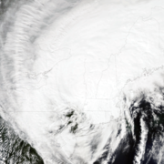
On August 28, 2011 Tropical Storm Irene made landfall in New England, leading to coastal storm surge, significant riverine flooding, sediment transport to Long Island Sound, and major infrastructure damage and destruction. Ten years later, the USGS New England Water Science Center looks back at Irene, the data collected by our Center during the event, the response by our employees before, during and after the event, and how the event changed the way we do business.

On August 28, 2011 Tropical Storm Irene reached the coast of New England and traversed through western Connecticut and Massachusetts and then along the New Hampshire/Vermont border and eventually exited New England through northern Maine. Irene was downgraded from a hurricane to a tropical storm prior to reaching New England as winds subsided to approximately 55 mph, and again downgraded to an extratropical storm as winds dropped to near 45 mph. Irene caused coastal damage in western Connecticut due to the storm surge associated with the high winds and significant damage to roadways, bridges, and other infrastructure due to the tremendous amounts of rainfall during the storm. The U.S. Geological Survey (USGS) New England Water Science Center responded to the storm surge and severe flooding caused by Irene before, during, and after the storm by monitoring tidal storm surge and collecting measurements of river stage and discharge. In some cases, there was record-breaking river stage elevations and associated discharge, especially in Vermont and western New Hampshire.
Leading up to the 10-year anniversary of Tropical Storm Irene the New England Water Science Center posted numerous photographs and other content to highlight the historical significance of the storm and the response by the USGS New England Water Science Center. Additionally, we posted content on our Facebook page using the hashtag #21DaysofIrene.
We focus on the preparation for the storm and some of the coastal and riverine flooding caused by the storm. Preparation was primarily deploying storm surge sensors along New England’s coastline and getting teams ready to go into the field to get discharge measurements of flooding rivers throughout the most impacted areas of New England.
We also feature continued USGS New England Water Science Center response during and after the storm, as well as lessons learned and how USGS has changed their way of responding to this type of storm event.
Below are other science projects associated with this information.
New England Flood Information
Surge, Wave, and Tide Hydrodynamics (SWaTH) Network
Below are publications associated with this information.
Barrier island breach evolution: Alongshore transport and bay-ocean pressure gradient interactions
Flood-inundation maps for the Green River in Colrain, Leyden, and Greenfield, Massachusetts, from U.S. Geological Survey streamgage 01170100 Green River near Colrain to the confluence with the Deerfield River
Tropical storm Irene flood of August 2011 in northwestern Massachusetts
Post-Hurricane Irene coastal oblique aerial photographs collected from Ocracoke Inlet, North Carolina, to Virginia Beach, Virginia, August 30-31, 2011
Assessing the impact of Hurricanes Irene and Sandy on the morphology and modern sediment thickness on the inner continental shelf offshore of Fire Island, New York
Flood Map for the Winooski River in Waterbury, Vermont, 2014
Flood recovery maps for the White River in Bethel, Stockbridge, and Rochester, Vermont, and the Tweed River in Stockbridge and Pittsfield, Vermont, 2014
Flooding in the Northeastern United States, 2011
Analysis of floods, including the tropical storm Irene inundation, of the Ottauquechee River in Woodstock, Bridgewater, and Killington and of Reservoir Brook in Bridgewater and Plymouth, Vermont
Flood inundation maps and water-surface profiles for tropical storm Irene and selected annual exceedance probability floods for Flint Brook and the Third Branch White River in Roxbury, Vermont
Source, conveyance and fate of suspended sediments following Hurricane Irene. New England, USA
High-water marks from tropical storm Irene for selected river reaches in northwestern Massachusetts, August 2011
- Overview
On August 28, 2011 Tropical Storm Irene made landfall in New England, leading to coastal storm surge, significant riverine flooding, sediment transport to Long Island Sound, and major infrastructure damage and destruction. Ten years later, the USGS New England Water Science Center looks back at Irene, the data collected by our Center during the event, the response by our employees before, during and after the event, and how the event changed the way we do business.
Sources/Usage: Public Domain. Visit Media to see details.This image shows the track of Irene and the storm's classification as it traveled northward. (Public domain.) On August 28, 2011 Tropical Storm Irene reached the coast of New England and traversed through western Connecticut and Massachusetts and then along the New Hampshire/Vermont border and eventually exited New England through northern Maine. Irene was downgraded from a hurricane to a tropical storm prior to reaching New England as winds subsided to approximately 55 mph, and again downgraded to an extratropical storm as winds dropped to near 45 mph. Irene caused coastal damage in western Connecticut due to the storm surge associated with the high winds and significant damage to roadways, bridges, and other infrastructure due to the tremendous amounts of rainfall during the storm. The U.S. Geological Survey (USGS) New England Water Science Center responded to the storm surge and severe flooding caused by Irene before, during, and after the storm by monitoring tidal storm surge and collecting measurements of river stage and discharge. In some cases, there was record-breaking river stage elevations and associated discharge, especially in Vermont and western New Hampshire.
Leading up to the 10-year anniversary of Tropical Storm Irene the New England Water Science Center posted numerous photographs and other content to highlight the historical significance of the storm and the response by the USGS New England Water Science Center. Additionally, we posted content on our Facebook page using the hashtag #21DaysofIrene.
We focus on the preparation for the storm and some of the coastal and riverine flooding caused by the storm. Preparation was primarily deploying storm surge sensors along New England’s coastline and getting teams ready to go into the field to get discharge measurements of flooding rivers throughout the most impacted areas of New England.
We also feature continued USGS New England Water Science Center response during and after the storm, as well as lessons learned and how USGS has changed their way of responding to this type of storm event.
This photo taken on August 30, 2011 shows what used to be the parking lot where we parked our field vehicle during a previous deployment. The rocks in the forefront used to be part of the paved parking lot that was largely destroyed during Irene. (Credit: Jonathan Morrison, U.S. Geological Survey. Public domain.) This photograph of the White River near West Hartford, Vermont (USGS station ID 01144000, gage on the left) was taken on August 29, 2011 and is looking upstream towards the USGS gage. The White River flooded Route 14 in the photo and caused significant damage and erosion along the roadway and in the town. The monitoring equipment in the gage was destroyed by floodwaters that overtopped the equipment inside the gage.
The impacts of Tropical Storm Irene lingered on long after the storm. This photo shows the Green River in Great Barrington, Massachusetts (USGS station ID 01198000) and was taken on May 14, 2012, almost a year after Irene. This tree was lodged under the Hurlburt Rd. bridge during Irene and was still lodged under the bridge after the storm. It was removed by the State of Massachusetts later that year. The tree caused the river to change course and it has been eroding the bank on the opposite side ever since; the property owner lost a fence due to the erosion.
A debris line was left on the ground where the river reached its peak at USGS station ID 010642505 Saco River at Bartlett, New Hampshire. This is a type of High-Water Mark that was flagged for an indirect measurement of discharge. Direct measurements using a flow meter cannot be used during this type of flood event. In this case, it was a slope-area measurement that resulted in 29,100 cubic feet per second of flow, or approximately 2,182,250 gallons of water per second flowing down the channel and well over bank. A High-Water Mark (HWM) at USGS station ID 01150900 Ottauquechee River at West Bridgewater, Vermont was observed at an undesirable location. It was inside the gage house and above the equipment, which was destroyed! Note the line of debris, known as a seed line, in between the two shelves, which was the peak of the river during Irene. The HWM was used to compute an indirect measurement of discharge. In this case, a contracted-opening measurement (flow through a bridge or other structure) resulted in 9,070 cubic feet per second of flow, or approximately 68,025 gallons of water passing in one second.
- Science
Below are other science projects associated with this information.
New England Flood Information
The USGS delivers continuous streamflow, stage (water-level), and tide data to help emergency managers and other decision makers protect life and property caused by floods and other water-related hazards.Surge, Wave, and Tide Hydrodynamics (SWaTH) Network
During large coastal storms, the storm surge and waves are the main cause of destruction and landscape change, transporting saline water, sediment, and debris inland. The USGS, in collaboration with stakeholders, has constructed a national Surge, Wave, and Tide Hydrodynamics (SWaTH) Network for the Atlantic, Eastern Pacific, and Central Pacific. SWaTH monitors and documents the height, extent, and... - Multimedia
- Publications
Below are publications associated with this information.
Filter Total Items: 19Barrier island breach evolution: Alongshore transport and bay-ocean pressure gradient interactions
Physical processes controlling repeated openings and closures of a barrier island breach between a bay and the open ocean are studied using aerial photographs and atmospheric and hydrodynamic observations. The breach site is located on Pea Island along the Outer Banks, separating Pamlico Sound from the Atlantic Ocean. Wind direction was a major control on the pressure gradients between the bay andAuthorsIlgar Safak, John C. Warner, Jeffrey H. ListFlood-inundation maps for the Green River in Colrain, Leyden, and Greenfield, Massachusetts, from U.S. Geological Survey streamgage 01170100 Green River near Colrain to the confluence with the Deerfield River
The U.S. Geological Survey developed flood elevations in cooperation with the Federal Emergency Management Agency for a 14.3-mile reach of the Green River in Colrain, Leyden, and Greenfield, Massachusetts, to assist landowners and emergency management workers to prepare for and recover from floods. The river reach extends from the U.S. Geological Survey Green River near Colrain, MA (01170100) streAuthorsRobert H. Flynn, Gardner C. Bent, Pamela J. LombardTropical storm Irene flood of August 2011 in northwestern Massachusetts
A Presidential disaster was declared in northwestern Massachusetts, following flooding from tropical storm Irene on August 28, 2011. During the storm, 3 to 10 inches of rain fell on soils that were susceptible to flash flooding because of wet antecedent conditions. The gage height at one U.S. Geological Survey streamgage rose nearly 20 feet in less than 4 hours because of the combination of saturaAuthorsGardner C. Bent, Scott A. Olson, Andrew J. MasseyPost-Hurricane Irene coastal oblique aerial photographs collected from Ocracoke Inlet, North Carolina, to Virginia Beach, Virginia, August 30-31, 2011
The U.S. Geological Survey (USGS), as part of the National Assessment of Coastal Change Hazards project, conducts baseline and storm-response photography missions to document and understand the changes in vulnerability of the Nation's coasts to extreme storms (Morgan, 2009). On August 30-31, 2011, the USGS conducted an oblique aerial photographic survey from Ocracoke Inlet, North Carolina, to VirgAuthorsKaren L. M. Morgan, M. Dennis KrohnAssessing the impact of Hurricanes Irene and Sandy on the morphology and modern sediment thickness on the inner continental shelf offshore of Fire Island, New York
This report documents the changes in seabed morphology and modern sediment thickness detected on the inner continental shelf offshore of Fire Island, New York, before and after Hurricanes Irene and Sandy made landfall. Comparison of acoustic backscatter imagery, seismic-reflection profiles, and bathymetry collected in 2011 and in 2014 show that sedimentary structures and depositional patterns moveAuthorsWilliam C. Schwab, Wayne E. Baldwin, Jane F. DennyFlood Map for the Winooski River in Waterbury, Vermont, 2014
From August 28 to 29, 2011, Tropical Storm Irene delivered rainfall ranging from approximately 4 to more than 7 inches in the Winooski River Basin in Vermont. The rainfall resulted in severe flooding throughout the basin and significant damage along the Winooski River. In response to the flooding, the U.S. Geological Survey (USGS), in cooperation with the Federal Emergency Management Agency, conduAuthorsScott A. OlsonFlood recovery maps for the White River in Bethel, Stockbridge, and Rochester, Vermont, and the Tweed River in Stockbridge and Pittsfield, Vermont, 2014
From August 28 to 29, 2011, Tropical Storm Irene delivered rainfall ranging from about 4 inches to more than 7 inches in the White River Basin. The rainfall resulted in severe flooding throughout the basin and significant damage along the White River and Tweed River. In response to the flooding, the U.S. Geological Survey, in cooperation with the Federal Emergency Management Agency, conducted a neAuthorsScott A. OlsonFlooding in the Northeastern United States, 2011
Flooding in the Northeastern United States during 2011 was widespread and record setting. This report summarizes peak streamflows that were recorded by the U.S. Geological Survey (USGS) during separate flooding events in February, March, April, May, July, August, and September. The flooding of late April, which combined snowmelt and heavy rain and the floods associated with the tropical storms ofAuthorsThomas P. Suro, Mark A. Roland, Richard G. KiahAnalysis of floods, including the tropical storm Irene inundation, of the Ottauquechee River in Woodstock, Bridgewater, and Killington and of Reservoir Brook in Bridgewater and Plymouth, Vermont
Digital flood-inundation maps were created by the U.S. Geological Survey (USGS) in cooperation with the U.S. Army Corps of Engineers, New York District for a 25-mile reach of the Ottauquechee River and a 2-mile reach of Reservoir Brook in Vermont. The reach of the Ottauquechee River that was studied extends from River Road Bridge in Killington, Vt., to the Taftsville Dam in the village of TaftsvilAuthorsRobert H. FlynnFlood inundation maps and water-surface profiles for tropical storm Irene and selected annual exceedance probability floods for Flint Brook and the Third Branch White River in Roxbury, Vermont
Flint Brook, a tributary to the Third Branch White River in Roxbury, Vermont, has a history of flooding the Vermont Fish and Wildlife Department’s Roxbury Fish Culture Station (the hatchery) and surrounding infrastructure. Flooding resulting from tropical storm Irene on August 28–29, 2011, caused widespread destruction in the region, including extensive and costly damages to the State-owned hatcheAuthorsElizabeth A. Ahearn, Pamela J. LombardSource, conveyance and fate of suspended sediments following Hurricane Irene. New England, USA
Hurricane Irene passed directly over the Connecticut River valley in late August, 2011. Intense precipitation and high antecedent soil moisture resulted in record flooding, mass wasting and fluvial erosion, allowing for observations of how these rare but significant extreme events affect a landscape still responding to Pleistocene glaciation and associated sediment emplacement. Clays and silts froAuthorsBrian Yellen, Jon D. Woodruff, Laura N. Kratz, Steven B. Mabee, Jonathan Morrison, Anna M. MartiniHigh-water marks from tropical storm Irene for selected river reaches in northwestern Massachusetts, August 2011
A Presidential Disaster Declaration was issued for Massachusetts, with a focus on the northwestern counties, following flooding from tropical storm Irene on August 28–29, 2011. Three to 10 inches of rain fell during the storm on soils that were susceptible to flash flooding because of wet antecedent conditions. The gage height at one U.S. Geological Survey (USGS) streamgage rose nearly 20 feet inAuthorsGardner C. Bent, Laura Medalie, Martha G. Nielsen