


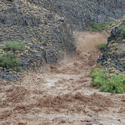
Remote Camera, 30-mile Camp (River MIe 30.7)
Paul Grams, Ph.D.
Paul Grams is a geomorphologist at the Southwest Biological Science Center's field station, Grand Canyon Monitoring and Research Center. He manages a set of projects collectively called the River Geomorphology and Geomorphic Change project. These include a range of studies that describe, quantify, and predict geomorphic change, mostly on large rivers in the western United States.
Additional Links
Additional Links
Paul Grams received a BA in Geology from Middlebury College (1991), an M.S. in Geology from Utah State University (1997), and a Ph.D. in Geography and Environmental Engineering from Johns Hopkins University (2006). For an undergraduate thesis, Paul examined the effects of Hells Canyon Dam on the hydrology and downstream physical resources of the Snake River in Idaho.
Since that time, he has studied the interaction between human-induced changes in hydrology and channel form on many segments of the Green River in Utah and Colorado, small streams in northern Utah and southern Idaho, and the Colorado River in Grand Canyon.
Paul’s current research interests are in fluvial geomorphology, sediment transport, the downstream effects of dams and diversions, and the connections between physical processes and ecological systems on large rivers. Paul is currently a research hydrologist at the Grand Canyon Monitoring and Research Center and manages several projects related to geomorphology, sediment budgets, and the effects of controlled floods on the Colorado River in Grand Canyon and in other parts of the Colorado River Basin.
Science and Products
A New App to Report Flash Floods and Debris Flows in Grand Canyon
A new community science tool helps scientists gather valuable information on hazardous events such as floods, debris flows, and landslides that occur in the backcountry of Grand Canyon National Park. Visitors to Grand Canyon can help improve our understanding of the impacts these events have which helps to improve future warnings.

River Geomorphology, Sediment Storage, Sandbar and Campsite Monitoring in Grand Canyon
River channels and their adjacent floodplains are ever evolving in form and composition in response to changing patterns of streamflow, the quantity and size of supplied sediment, and feedbacks with the riparian and aquatic ecosystems. Changes in channel form affect aquatic and riparian habitats, which are important for plants, animals, and insects. Erosion and deposition of river channels and...

High-Flow Experiments on the Colorado River
Glen Canyon Dam has altered flow and sediment dynamics of the Colorado River in Grand Canyon. Before the dam was completed in 1963, the Colorado River carried a large amount of sand, silt, and clay through Grand Canyon, some of which was deposited during spring floods to create large and abundant sandbars. Sandbars in Grand Canyon are valued as camping areas, create aquatic and riparian habitat...

Is timing really everything? Evaluating Resource Response to Spring Disturbance Flows
Glen Canyon Dam has altered ecological processes of the Colorado River in Grand Canyon. Before the dam was built, the Colorado River experienced seasonable variable flow rates, including springtime flooding events. These spring floods scoured the river bottom and enhanced natural processes that sustained the Colorado River ecosystem. Since the dam’s construction in 1963, springtime floods have...

Mapping Land-Use, Hazard Vulnerability and Habitat Suitability Using Deep Neural Networks
Deep learning is a computer analysis technique inspired by the human brain’s ability to learn. It involves several layers of artificial neural networks to learn and subsequently recognize patterns in data, forming the basis of many state-of-the-art applications from self-driving cars to drug discovery and cancer detection. Deep neural networks are capable of learning many levels of...

Evaluation of UAS photogrammetry and comparison to ground and aerial surveys for monitoring geomorphic condition of fine sediment deposits along the Colorado River
At the Grand Canyon Monitoring and Research Center (GCMRC), we are looking for affordable and efficient alternatives and augmentations to our current approaches to monitoring the geomorphic condition of sandbars, terraces and other fine-sediment deposits along the Colorado River in the Grand Canyon region, Arizona.

Remote Camera, 30-mile Camp (River MIe 30.7)
Science and Products
A New App to Report Flash Floods and Debris Flows in Grand Canyon
A new community science tool helps scientists gather valuable information on hazardous events such as floods, debris flows, and landslides that occur in the backcountry of Grand Canyon National Park. Visitors to Grand Canyon can help improve our understanding of the impacts these events have which helps to improve future warnings.
River Geomorphology, Sediment Storage, Sandbar and Campsite Monitoring in Grand Canyon
River channels and their adjacent floodplains are ever evolving in form and composition in response to changing patterns of streamflow, the quantity and size of supplied sediment, and feedbacks with the riparian and aquatic ecosystems. Changes in channel form affect aquatic and riparian habitats, which are important for plants, animals, and insects. Erosion and deposition of river channels and...
High-Flow Experiments on the Colorado River
Glen Canyon Dam has altered flow and sediment dynamics of the Colorado River in Grand Canyon. Before the dam was completed in 1963, the Colorado River carried a large amount of sand, silt, and clay through Grand Canyon, some of which was deposited during spring floods to create large and abundant sandbars. Sandbars in Grand Canyon are valued as camping areas, create aquatic and riparian habitat...
Is timing really everything? Evaluating Resource Response to Spring Disturbance Flows
Glen Canyon Dam has altered ecological processes of the Colorado River in Grand Canyon. Before the dam was built, the Colorado River experienced seasonable variable flow rates, including springtime flooding events. These spring floods scoured the river bottom and enhanced natural processes that sustained the Colorado River ecosystem. Since the dam’s construction in 1963, springtime floods have...
Mapping Land-Use, Hazard Vulnerability and Habitat Suitability Using Deep Neural Networks
Deep learning is a computer analysis technique inspired by the human brain’s ability to learn. It involves several layers of artificial neural networks to learn and subsequently recognize patterns in data, forming the basis of many state-of-the-art applications from self-driving cars to drug discovery and cancer detection. Deep neural networks are capable of learning many levels of...
Evaluation of UAS photogrammetry and comparison to ground and aerial surveys for monitoring geomorphic condition of fine sediment deposits along the Colorado River
At the Grand Canyon Monitoring and Research Center (GCMRC), we are looking for affordable and efficient alternatives and augmentations to our current approaches to monitoring the geomorphic condition of sandbars, terraces and other fine-sediment deposits along the Colorado River in the Grand Canyon region, Arizona.
Remote Camera, 30-mile Camp (River MIe 30.7)
Remote Camera, 30-mile Camp (River MIe 30.7)