
The inner workings of the BOBSled bottle.
Seth D. Ackerman
Seth Ackerman is a Geologist at the USGS Woods Hole Coastal and Marine Science Center. He has worked with the Seafloor Mapping Group since 2003 and the Aerial Imaging and Mapping Group since 2018.
Science and Products
Coastal and Marine Science in Long Island Sound
Long Island Sound is a highly productive estuary and vital natural resource bordering New York and Connecticut. It’s essential for its massive economic impact, generating billions annually by supporting recreation, fisheries, and transportation, as well as its biodiversity, serving as a critical habitat for thousands of marine species. USGS research in Long Island Sound helps protect these...

Geologic Mapping of the Massachusetts Seafloor
The U.S. Geological Survey, in cooperation with the Massachusetts Office of Coastal Zone Management (CZM) is conducting geologic mapping of the sea floor to characterize the surface and shallow subsurface geologic framework within the Massachusetts coastal zone. The long-term goal of this mapping effort is to produce high-resolution geologic maps and a Geographic Information System (GIS) that will...

Sea Floor Mapping Group
The Sea Floor Mapping Group (SFMG) is a core capability at the Woods Hole Coastal & Marine Science Center (WHCMSC) that provides support for coastal, lacustrine and marine geologic research. The staff has a wide-range of expertise and is responsible for geophysical and sampling data acquisition, processing, interpretation and publication, logistics, design, and research and development. SFMG has...

Aerial Imaging and Mapping
The Aerial Imaging and Mapping group (AIM), at the U.S. Geological Survey Woods (USGS) Hole Coastal and Marine Science Center provides UAS services to scientists to advance the science mission of the Coastal and Marine Geology Program. Scientists at the Woods Hole Coastal and Marine Science Center have been using UASs to acquire imagery of coastal and wetland environments, which is then used to...

BOBSled bottle
The inner workings of the BOBSled bottle.

Learning about BOBSled
Gerry Hatcher discussing BOBSled technology to help inform the development of SEABOSS 3.0.
Gerry Hatcher discussing BOBSled technology to help inform the development of SEABOSS 3.0.

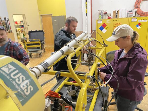
BOBSled
Scientists and technologists from the Woods Hole Coastal and Marine Science Center (WHCMSC) in Woods Hole, Massachusetts traveled to the Pacific Coastal and Marine Science Center (PCMSC) in Santa Cruz, California to learn about their seafloor imaging and sampling instrument—the Benthic Observation camera Sled, or BOBSled.
Scientists and technologists from the Woods Hole Coastal and Marine Science Center (WHCMSC) in Woods Hole, Massachusetts traveled to the Pacific Coastal and Marine Science Center (PCMSC) in Santa Cruz, California to learn about their seafloor imaging and sampling instrument—the Benthic Observation camera Sled, or BOBSled.
Learning about BOBSled
Scientists and technologists from the Woods Hole Coastal and Marine Science Center (WHCMSC) in Woods Hole, Massachusetts traveled to the Pacific Coastal and Marine Science Center (PCMSC) in Santa Cruz, California to learn about their seafloor imaging and sampling instrument—the Benthic Observation camera Sled, or BOBSled.
Scientists and technologists from the Woods Hole Coastal and Marine Science Center (WHCMSC) in Woods Hole, Massachusetts traveled to the Pacific Coastal and Marine Science Center (PCMSC) in Santa Cruz, California to learn about their seafloor imaging and sampling instrument—the Benthic Observation camera Sled, or BOBSled.

Splicing fiber optic cable
Scientists and technologists from the Woods Hole Coastal and Marine Science Center (WHCMSC) in Woods Hole, Massachusetts traveled to the Pacific Coastal and Marine Science Center (PCMSC) in Santa Cruz, California to learn about their seafloor imaging and sampling instrument—the Benthic Observation camera Sled, or BOBSled.
Scientists and technologists from the Woods Hole Coastal and Marine Science Center (WHCMSC) in Woods Hole, Massachusetts traveled to the Pacific Coastal and Marine Science Center (PCMSC) in Santa Cruz, California to learn about their seafloor imaging and sampling instrument—the Benthic Observation camera Sled, or BOBSled.

Viewing BOBSled
Scientists and technicians from the Woods Hole Coastal and Marine Science Center (WHCMSC) in Woods Hole, Massachusetts traveled to the Pacific Coastal and Marine Science Center (PCMSC) in Santa Cruz, California to learn about their seafloor imaging and sampling instrument—the Benthic Observation camera Sled, or BOBSled.
Scientists and technicians from the Woods Hole Coastal and Marine Science Center (WHCMSC) in Woods Hole, Massachusetts traveled to the Pacific Coastal and Marine Science Center (PCMSC) in Santa Cruz, California to learn about their seafloor imaging and sampling instrument—the Benthic Observation camera Sled, or BOBSled.

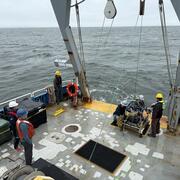
USGS Scientists and Survey Technicians deploying geophysical survey systems on the R/V Pelican in the Gulf of Mexico
USGS Scientists and Survey Technicians deploying geophysical survey systems on the R/V Pelican in the Gulf of MexicoUSGS Scientists and Survey Technicians from the Woods Hole Coastal and Marine Science Center (Laura Brothers, Dave Foster, Pat Berube and Chuck Worley) deploying geophysical survey systems on the R/V Pelican in the Gulf of Mexico.
Fall 2023 Photo Contest Winner: Seth Ackerman, Honorable Mention category

USGS scientists watching real time video feed from Stellwagen Bank National Marine Sanctuary
USGS scientists watching real time video feed from Stellwagen Bank National Marine SanctuaryMaeve Munnelly and Marie Bartlett watching the real-time video feed from the mini SEABed Observation and Sampling System (mini-SEABOSS) aboard the R/V Auk during a survey with scientists from the NOAA Stellwagen Bank National Marine Sanctuary (SBNMS).

SeaBOSS Survey on Stellwagen Bank National Marine Sanctuary
SeaBOSS Survey on Stellwagen Bank National Marine SanctuaryMarie Bartlett and Maeve Munnelly setting up the mini SEABed Observation and Sampling System (mini-SEABOSS) aboard the R/V Auk during a survey with scientists from the NOAA Stellwagen Bank National Marine Sanctuary (SBNMS).

SeaBOSS survey on Stellwagen Bank National Marine Sanctuary
SeaBOSS survey on Stellwagen Bank National Marine SanctuaryMaeve Munnelly and Tammy Silva (SBNMS) looking for sandlance in the sediment grab collected with the mini SEABed Observation and Sampling System (mini-SEABOSS) aboard the R/V Auk during a survey with scientists from the NOAA Stellwagen Bank National Marine Sanctuary (SBNMS).

Stellwagen Bank National Marine Sanctuary Survey
Maeve Munnelly, Marie Bartlett and Seth Ackerman on the deck of the R/V Auk with the mini SEABed Observation and Sampling System (mini-SEABOSS) during a survey with scientists from the NOAA Stellwagen Bank National Marine Sanctuary (SBNMS).
Maeve Munnelly, Marie Bartlett and Seth Ackerman on the deck of the R/V Auk with the mini SEABed Observation and Sampling System (mini-SEABOSS) during a survey with scientists from the NOAA Stellwagen Bank National Marine Sanctuary (SBNMS).
Science and Products
Coastal and Marine Science in Long Island Sound
Long Island Sound is a highly productive estuary and vital natural resource bordering New York and Connecticut. It’s essential for its massive economic impact, generating billions annually by supporting recreation, fisheries, and transportation, as well as its biodiversity, serving as a critical habitat for thousands of marine species. USGS research in Long Island Sound helps protect these...
Geologic Mapping of the Massachusetts Seafloor
The U.S. Geological Survey, in cooperation with the Massachusetts Office of Coastal Zone Management (CZM) is conducting geologic mapping of the sea floor to characterize the surface and shallow subsurface geologic framework within the Massachusetts coastal zone. The long-term goal of this mapping effort is to produce high-resolution geologic maps and a Geographic Information System (GIS) that will...
Sea Floor Mapping Group
The Sea Floor Mapping Group (SFMG) is a core capability at the Woods Hole Coastal & Marine Science Center (WHCMSC) that provides support for coastal, lacustrine and marine geologic research. The staff has a wide-range of expertise and is responsible for geophysical and sampling data acquisition, processing, interpretation and publication, logistics, design, and research and development. SFMG has...
Aerial Imaging and Mapping
The Aerial Imaging and Mapping group (AIM), at the U.S. Geological Survey Woods (USGS) Hole Coastal and Marine Science Center provides UAS services to scientists to advance the science mission of the Coastal and Marine Geology Program. Scientists at the Woods Hole Coastal and Marine Science Center have been using UASs to acquire imagery of coastal and wetland environments, which is then used to...
BOBSled bottle
The inner workings of the BOBSled bottle.
The inner workings of the BOBSled bottle.
Learning about BOBSled
Gerry Hatcher discussing BOBSled technology to help inform the development of SEABOSS 3.0.
Gerry Hatcher discussing BOBSled technology to help inform the development of SEABOSS 3.0.
BOBSled
Scientists and technologists from the Woods Hole Coastal and Marine Science Center (WHCMSC) in Woods Hole, Massachusetts traveled to the Pacific Coastal and Marine Science Center (PCMSC) in Santa Cruz, California to learn about their seafloor imaging and sampling instrument—the Benthic Observation camera Sled, or BOBSled.
Scientists and technologists from the Woods Hole Coastal and Marine Science Center (WHCMSC) in Woods Hole, Massachusetts traveled to the Pacific Coastal and Marine Science Center (PCMSC) in Santa Cruz, California to learn about their seafloor imaging and sampling instrument—the Benthic Observation camera Sled, or BOBSled.
Learning about BOBSled
Scientists and technologists from the Woods Hole Coastal and Marine Science Center (WHCMSC) in Woods Hole, Massachusetts traveled to the Pacific Coastal and Marine Science Center (PCMSC) in Santa Cruz, California to learn about their seafloor imaging and sampling instrument—the Benthic Observation camera Sled, or BOBSled.
Scientists and technologists from the Woods Hole Coastal and Marine Science Center (WHCMSC) in Woods Hole, Massachusetts traveled to the Pacific Coastal and Marine Science Center (PCMSC) in Santa Cruz, California to learn about their seafloor imaging and sampling instrument—the Benthic Observation camera Sled, or BOBSled.
Splicing fiber optic cable
Scientists and technologists from the Woods Hole Coastal and Marine Science Center (WHCMSC) in Woods Hole, Massachusetts traveled to the Pacific Coastal and Marine Science Center (PCMSC) in Santa Cruz, California to learn about their seafloor imaging and sampling instrument—the Benthic Observation camera Sled, or BOBSled.
Scientists and technologists from the Woods Hole Coastal and Marine Science Center (WHCMSC) in Woods Hole, Massachusetts traveled to the Pacific Coastal and Marine Science Center (PCMSC) in Santa Cruz, California to learn about their seafloor imaging and sampling instrument—the Benthic Observation camera Sled, or BOBSled.
Viewing BOBSled
Scientists and technicians from the Woods Hole Coastal and Marine Science Center (WHCMSC) in Woods Hole, Massachusetts traveled to the Pacific Coastal and Marine Science Center (PCMSC) in Santa Cruz, California to learn about their seafloor imaging and sampling instrument—the Benthic Observation camera Sled, or BOBSled.
Scientists and technicians from the Woods Hole Coastal and Marine Science Center (WHCMSC) in Woods Hole, Massachusetts traveled to the Pacific Coastal and Marine Science Center (PCMSC) in Santa Cruz, California to learn about their seafloor imaging and sampling instrument—the Benthic Observation camera Sled, or BOBSled.
USGS Scientists and Survey Technicians deploying geophysical survey systems on the R/V Pelican in the Gulf of Mexico
USGS Scientists and Survey Technicians deploying geophysical survey systems on the R/V Pelican in the Gulf of MexicoUSGS Scientists and Survey Technicians from the Woods Hole Coastal and Marine Science Center (Laura Brothers, Dave Foster, Pat Berube and Chuck Worley) deploying geophysical survey systems on the R/V Pelican in the Gulf of Mexico.
Fall 2023 Photo Contest Winner: Seth Ackerman, Honorable Mention category
USGS scientists watching real time video feed from Stellwagen Bank National Marine Sanctuary
USGS scientists watching real time video feed from Stellwagen Bank National Marine SanctuaryMaeve Munnelly and Marie Bartlett watching the real-time video feed from the mini SEABed Observation and Sampling System (mini-SEABOSS) aboard the R/V Auk during a survey with scientists from the NOAA Stellwagen Bank National Marine Sanctuary (SBNMS).
SeaBOSS Survey on Stellwagen Bank National Marine Sanctuary
SeaBOSS Survey on Stellwagen Bank National Marine SanctuaryMarie Bartlett and Maeve Munnelly setting up the mini SEABed Observation and Sampling System (mini-SEABOSS) aboard the R/V Auk during a survey with scientists from the NOAA Stellwagen Bank National Marine Sanctuary (SBNMS).
SeaBOSS survey on Stellwagen Bank National Marine Sanctuary
SeaBOSS survey on Stellwagen Bank National Marine SanctuaryMaeve Munnelly and Tammy Silva (SBNMS) looking for sandlance in the sediment grab collected with the mini SEABed Observation and Sampling System (mini-SEABOSS) aboard the R/V Auk during a survey with scientists from the NOAA Stellwagen Bank National Marine Sanctuary (SBNMS).
Stellwagen Bank National Marine Sanctuary Survey
Maeve Munnelly, Marie Bartlett and Seth Ackerman on the deck of the R/V Auk with the mini SEABed Observation and Sampling System (mini-SEABOSS) during a survey with scientists from the NOAA Stellwagen Bank National Marine Sanctuary (SBNMS).
Maeve Munnelly, Marie Bartlett and Seth Ackerman on the deck of the R/V Auk with the mini SEABed Observation and Sampling System (mini-SEABOSS) during a survey with scientists from the NOAA Stellwagen Bank National Marine Sanctuary (SBNMS).