
Assessment of Post-Fire Risk in California and Washington
In FY 2022, USGS received disaster supplement funds (Public Law 117-43) for the following activities:
Post-wildfire risk assessment: tasks and benefits 2022
Media
Sources/Usage: Public Domain. View Media Details
- The effects of wildfire in California (Caldor, Dixie, and KNP Complex Fires) and Washington State (Cedar Creek and Muckamuck Fires) may persist for years as vegetation regrows and landscapes recover.
- Funding will be used to address the needs of land and emergency management agencies at the Federal, Tribal, State, and local levels by providing new information to identify information gaps, support recovery planning, and aid in recovery and rebuilding decisions.
- Funding will also be used to focus on data and information for vegetation recovery for resource management, debris-flow hazard assessments in priority high-risk areas for recovery and emergency planning, and water flow and quality modeling water-supply protection.
Return to 2022 Supplemental Appropriations Activities
Related

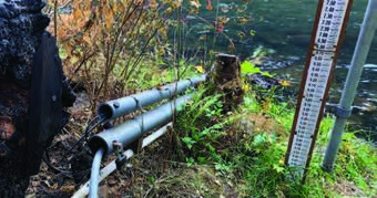
Postfire Landslide Monitoring Station: "Chips" (2021 Dixie Fire) near Belden, CA
Wildfire can increase landslide susceptibility in mountainous terrain. The USGS maintains postfire landslide monitoring stations to track hillslope hydrologic conditions in the years following fire.

Postfire Landslide Monitoring Station: "Chambers" (2021 Dixie Fire) near Belden, CA
Wildfire can increase landslide susceptibility in mountainous terrain. The USGS maintains postfire landslide monitoring stations to track hillslope hydrologic conditions in the years following fire.
"Chips" - Recent Conditions
Recent Monitoring Data
Related
Postfire Landslide Monitoring Station: "Chips" (2021 Dixie Fire) near Belden, CA
Wildfire can increase landslide susceptibility in mountainous terrain. The USGS maintains postfire landslide monitoring stations to track hillslope hydrologic conditions in the years following fire.
Postfire Landslide Monitoring Station: "Chambers" (2021 Dixie Fire) near Belden, CA
Wildfire can increase landslide susceptibility in mountainous terrain. The USGS maintains postfire landslide monitoring stations to track hillslope hydrologic conditions in the years following fire.
"Chips" - Recent Conditions
Recent Monitoring Data