
Coastal Assessments and Risk Forecasts from Hurricane Ida
In FY 2022, USGS received disaster supplement funds (Public Law 117-43) for the following activities:
Hurricane/coastal assessment and risk: tasks and benefits 2022
Media
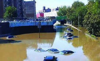
Sources/Usage: Public Domain. View Media Details
- As Hurricane Ida made landfall in the Gulf of Mexico, Louisiana’s protective barrier islands and marshes deteriorated and shifted landward. After the storm moved inland, it stalled over New York City, where stormwater management infrastructure was overwhelmed and resulted in extensive flooding of streets, buildings, subways, and other public spaces.
- These local and immediate effects complicate the efforts of community and public land managers responsible for protection, planning development, and recovery efforts.
- Funding will be used to update data and analysis in Louisiana and New York to accurately forecast flooding and erosion hazards, improving future storm-response operations, and to address resilience.
Related
Filter Total Items: 14
Lidar-derived Beach Morphology (Dune Crest, Dune Toe, and Shoreline) for U.S. Sandy Coastlines Lidar-derived Beach Morphology (Dune Crest, Dune Toe, and Shoreline) for U.S. Sandy Coastlines
The U.S. Geological Survey (USGS)Coastal Change Hazards Technical Capabilities and Applications (TCA) project aims to identify areas of the nation’s coastline that are most vulnerable to extreme storms and long-term shoreline change. These assessments require coastal elevation data across diverse geographic regions and covering a time span of many years. The datasets published here...
Storm-Induced Coastal Change Forecasts: Archive of Individual Storm Events Storm-Induced Coastal Change Forecasts: Archive of Individual Storm Events
These data sets contain information on the probabilities of storm-induced erosion (collision, inundation and overwash) on sandy beaches along the U.S. Gulf and Atlantic coasts during real-time peak forecast conditions. The analysis is based on a storm-impact scaling model that uses observations of beach morphology combined with sophisticated hydrodynamic models to predict how the coast...
Related
Filter Total Items: 14
Lidar-derived Beach Morphology (Dune Crest, Dune Toe, and Shoreline) for U.S. Sandy Coastlines Lidar-derived Beach Morphology (Dune Crest, Dune Toe, and Shoreline) for U.S. Sandy Coastlines
The U.S. Geological Survey (USGS)Coastal Change Hazards Technical Capabilities and Applications (TCA) project aims to identify areas of the nation’s coastline that are most vulnerable to extreme storms and long-term shoreline change. These assessments require coastal elevation data across diverse geographic regions and covering a time span of many years. The datasets published here...
Storm-Induced Coastal Change Forecasts: Archive of Individual Storm Events Storm-Induced Coastal Change Forecasts: Archive of Individual Storm Events
These data sets contain information on the probabilities of storm-induced erosion (collision, inundation and overwash) on sandy beaches along the U.S. Gulf and Atlantic coasts during real-time peak forecast conditions. The analysis is based on a storm-impact scaling model that uses observations of beach morphology combined with sophisticated hydrodynamic models to predict how the coast...