



Coastal Assessments and Risk Forecasts from Hurricane Ida
In FY 2022, USGS received disaster supplement funds (Public Law 117-43) for the following activities:
Hurricane/coastal assessment and risk: tasks and benefits 2022
Media
Sources/Usage: Public Domain. View Media Details
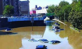
- As Hurricane Ida made landfall in the Gulf of Mexico, Louisiana’s protective barrier islands and marshes deteriorated and shifted landward. After the storm moved inland, it stalled over New York City, where stormwater management infrastructure was overwhelmed and resulted in extensive flooding of streets, buildings, subways, and other public spaces.
- These local and immediate effects complicate the efforts of community and public land managers responsible for protection, planning development, and recovery efforts.
- Funding will be used to update data and analysis in Louisiana and New York to accurately forecast flooding and erosion hazards, improving future storm-response operations, and to address resilience.
Related
Filter Total Items: 15
Storm-Induced Coastal Change Forecasts: Louisiana Hurricanes Laura and Delta 2020 Storm-Induced Coastal Change Forecasts: Louisiana Hurricanes Laura and Delta 2020
These datasets contain information on the probabilities of storm-induced erosion (collision, overwash and inundation) on sandy beaches along the U.S. Gulf coast of Texas, Louisiana, Mississippi, and Alabama during hurricane impact conditions of Hurricanes Laura and Delta in 2020. The analysis is based on a storm-impact scaling model that uses observations of dune morphology combined with
Coastal Land-Cover and Feature Datasets Derived From Landsat Satellite Imagery, Sabine Pass to Bay Coquette, Louisiana Coastal Land-Cover and Feature Datasets Derived From Landsat Satellite Imagery, Sabine Pass to Bay Coquette, Louisiana
This data release serves as an archive of coastal land-cover and feature datasets derived from Landsat satellite imagery from Sabine Pass to Bay Coquette, Louisiana (LA). A total of 179 images acquired between 2013 and 2024 were analyzed. Water, bare earth (sand), and vegetated land-cover classes were mapped using (1) successive thresholding and masking of the modified normalized...
Supporting Datasets and R Code for Compound Flood Hazard Modeling in the New York–Long Island Sound Region (ver. 2.0, May 2026) Supporting Datasets and R Code for Compound Flood Hazard Modeling in the New York–Long Island Sound Region (ver. 2.0, May 2026)
This data release includes a shapefile of compound flood hazard scores and the associated input data, scripts, and a sample output file necessary for calculating rain-surge return period adjustments for Long Island Sound and its surrounding areas. The raw input data and imputation scripts are included in this data release and are located in the "Imputation and data compilation.zip"...
Geospatial Dataset of Coastal Inundation Maps for Long Island, NY and Long Island Sound (CT/NY) Geospatial Dataset of Coastal Inundation Maps for Long Island, NY and Long Island Sound (CT/NY)
This data release contains shapefiles and raster data of spatially distributed water level inundation, water depth, wave discharge and a set of hazard ranks for water levels, waves, and a combination of both for coastal areas of Long Island, NY and Long Island Sound. Water inundation and depth data include both current and future projections of inundation based on 4 annual exceedance...
Geospatial Datasets of Factors Influencing Pluvial Flood Potential in Long Island, New York and Near Coastal Areas Surrounding Long Island Sound in New York, Connecticut, and Rhode Island Geospatial Datasets of Factors Influencing Pluvial Flood Potential in Long Island, New York and Near Coastal Areas Surrounding Long Island Sound in New York, Connecticut, and Rhode Island
This data release provides spatial digital data for factors that influence pluvial flood hazard potential, including closed depressions, curve number, drainage networks, topographic slope, average annual rainfall, 1-hr and 24-hour 100-year return period rainfall accumulation, and locations of recorded floods. In addition, these flood influencing factors are summarized to a common 900...
Geospatial Datasets of Factors Influencing Groundwater Emergence Flood Hazard in Long Island, New York and near Coastal Areas Surrounding Long Island Sound in New York, Connecticut, and Rhode Island Geospatial Datasets of Factors Influencing Groundwater Emergence Flood Hazard in Long Island, New York and near Coastal Areas Surrounding Long Island Sound in New York, Connecticut, and Rhode Island
This data release contains raster datasets representing depth to water table, calculated from steady-state groundwater models developed by the U.S. Geological Survey (Jahn and others, 2024; Barclay and others, 2024). The depth to water table rasters are available at an approximate resolution of 10 meters. In addition, depth to water table, hydrologic soil types, and landcover are...
Sediment Data From Surface Samples and Sand Augers Collected in 2023 From the Northern Chandeleur Islands, Louisiana Sediment Data From Surface Samples and Sand Augers Collected in 2023 From the Northern Chandeleur Islands, Louisiana
In 2023, scientists from the U.S. Geological Survey St. Petersburg Coastal and Marine Science Center (USGS SPCMSC) conducted a sediment sampling survey at the northern Chandeleur Islands, Louisiana. Funded by the Extending Government Funding and Delivering Emergency Assistance Act (Public Law 117-43) enacted on September 30, 2021, these data complement sediment data from samples...
Coastal Bathymetry and Backscatter Data Collected June-August 2023 From the Chandeleur Islands, Louisiana Coastal Bathymetry and Backscatter Data Collected June-August 2023 From the Chandeleur Islands, Louisiana
Scientists from the U.S. Geological Survey St. Petersburg Coastal and Marine Science Center in St. Petersburg, Florida (USGS–SPCSMC), conducted a geophysical survey of the northern Chandeleur Islands, Louisiana during two survey legs: June 12-21 and July 31-August 11, 2023. During this study, multibeam bathymetry and sub-bottom geophysical data (Forde and others, 2024) were collected...
Coastal Single-beam Bathymetry Data Collected in 2023 from the Chandeleur Islands, Louisiana Coastal Single-beam Bathymetry Data Collected in 2023 from the Chandeleur Islands, Louisiana
Scientists from the U.S. Geological Survey (USGS) St. Petersburg Coastal and Marine Science Center (SPCMSC) conducted single-beam and multibeam bathymetry (Stalk and others, 2025) surveys around the northern Chandeleur Islands, Louisiana, from June 12 to 20 and from July 31 to August 9, 2023, as part of Field Activity Number (FAN) 2023-325-FA. The purpose of data collection was to...
Chirp Sub-Bottom Profile Geophysical Data Collected in 2023 From the Chandeleur Islands, Louisiana Chirp Sub-Bottom Profile Geophysical Data Collected in 2023 From the Chandeleur Islands, Louisiana
As part of the 2022 Disaster Supplemental project, scientists from the U.S. Geological Survey (USGS) St. Petersburg Coastal and Marine Science Center (SPCMSC) conducted a nearshore geophysical survey to map the shoreface and inner shelf, as well as characterize stratigraphy near the Chandeleur Islands, Louisiana (LA) in June and August 2023. The purpose of this study was to conduct a...
Coastal Land-Cover and Feature Datasets Extracted from Landsat Satellite Imagery, Northern Chandeleur Islands, Louisiana Coastal Land-Cover and Feature Datasets Extracted from Landsat Satellite Imagery, Northern Chandeleur Islands, Louisiana
This data release serves as an archive of coastal land-cover and feature datasets derived from Landsat satellite imagery at the northern Chandeleur Islands, Louisiana. To minimize effects of tidal water-level variations, only images that were collected within 2 hours of predicted low tide or that were collected on a rising tide with predicted water levels less than mean sea level at time...
Storm-Induced Overwash Extent Storm-Induced Overwash Extent
The Coastal Change Hazards Technical Capabilities and Applications project at the U.S. Geological Survey (USGS) exists to understand and predict storm impacts to our nation’s coastlines. This data release defines the alongshore extent of overwash deposits, determined from aerial photograph analysis, attributed to coastal processes during storm events. Note: This data release was...
Storm surge barriers reduce seaward sediment supply to lagoonal estuaries Storm surge barriers reduce seaward sediment supply to lagoonal estuaries
Numerical simulations with realistic forcing of fixed infrastructure for a proposed storm surge barrier for a lagoonal estuary, Jamaica Bay (New York, USA), are analyzed during typical forcing conditions to assess alterations to flow and sediment transport with the barrier open. Lagoonal estuaries are shallow and have modest watershed freshwater and sediment inputs, so sediment delivery...
Authors
David K. Ralston, Philip M. Orton, John C. Warner, Shima Kasaei
Hazard potential of compound flooding from rainfall, storm surge, and groundwater in coastal New York and Connecticut Hazard potential of compound flooding from rainfall, storm surge, and groundwater in coastal New York and Connecticut
Compound flood events, the co-occurrence of multiple flood drivers, can result in flood hazard potential exceeding that of any single driver alone. To evaluate compound flooding in a semi-urbanized coastal area, historical records dating back to 1970 are used to study the co-occurrences of high precipitation, storm surge, and shallow groundwater conditions along the coastlines of New...
Authors
Robin L. Glas, Liv M. Herdman, Salme Ellen Cook, Archi Howlader, Kristina K. Masterson
Compounding of 100-year coastal floods by rainfall in an urban environment Compounding of 100-year coastal floods by rainfall in an urban environment
Coastal and pluvial flooding are both becoming more prevalent and severe due to climate change and urbanization in floodplains. The co-occurrence of these flood drivers is generally assumed to exacerbate the resulting flood impacts, a result referred to as compound flooding. However, few observational or modeling studies have investigated the circumstances under which this occurs. Here...
Authors
Shima Kasaei, Phillip M. Orton, Thomas Wahl, David K. Ralston, John C. Warner
Present and future coastal flooding hazard for Long Island, NY and Long Island Sound (NY/CT), USA Present and future coastal flooding hazard for Long Island, NY and Long Island Sound (NY/CT), USA
Coastal flooding and the associated damages due to storms are increasing with sea level rise around the world, with regional variability in the severity of impacts., Researchers and resource managers need to better understand and predict the future shifts in coastal flooding due to these processes to plan for resilient and sustainable communities. Here we present an analysis of long-term
Authors
Salme Ellen Cook, Liv M. Herdman
A spatial analysis of the groundwater emergence flood hazard in Long Island, New York and near coastal areas surrounding Long Island Sound in New York, Connecticut, and Rhode Island A spatial analysis of the groundwater emergence flood hazard in Long Island, New York and near coastal areas surrounding Long Island Sound in New York, Connecticut, and Rhode Island
Long Island, New York and near coastal areas surrounding Long Island Sound are densely populated and, like other coastal areas, are susceptible to flooding from several potential sources, including stormwater from precipitation events, tidal flooding and storm surge, and groundwater inundation or groundwater emergence flooding. The latter refers to the intersection of a rising water...
Authors
Kristina K. Masterson, Robert J. Welk, Janet R. Barclay, Kalle L. Jahn, Liv M. Herdman
Pluvial and potential compound flooding in a coupled coastal modeling framework: New York City during post-tropical Cyclone Ida (2021) Pluvial and potential compound flooding in a coupled coastal modeling framework: New York City during post-tropical Cyclone Ida (2021)
Many coastal urban areas are prone to extreme pluvial flooding due to limitations in stormwater system capacity, with the additional potential for flooding compounded by storm surge, tides, and waves. Understanding and simulating these processes can improve prediction and flood risk management. Here, we adapt the Coupled Ocean–Atmosphere–Wave–Sediment Transport modeling framework (COAWST...
Authors
Shima Kasaei, Phillip M. Orton, David K. Ralston, John C. Warner
Long Island Sound Partnership Compound Flood Hazard Web Map Application Long Island Sound Partnership Compound Flood Hazard Web Map Application
This Long Island Sound Partnership Compound Flood Hazard Web Map Application presents individual and combined flood hazard scores from rainfall, coastal storm surge and shallow or emerging groundwater on a 900-meter by 900-meter grid over a study area which encompasses New York City, and Long Island, and Long Island Sound Watersheds in Southeastern New York and Southern Connecticut.
Related
Filter Total Items: 15
Storm-Induced Coastal Change Forecasts: Louisiana Hurricanes Laura and Delta 2020 Storm-Induced Coastal Change Forecasts: Louisiana Hurricanes Laura and Delta 2020
These datasets contain information on the probabilities of storm-induced erosion (collision, overwash and inundation) on sandy beaches along the U.S. Gulf coast of Texas, Louisiana, Mississippi, and Alabama during hurricane impact conditions of Hurricanes Laura and Delta in 2020. The analysis is based on a storm-impact scaling model that uses observations of dune morphology combined with
Coastal Land-Cover and Feature Datasets Derived From Landsat Satellite Imagery, Sabine Pass to Bay Coquette, Louisiana Coastal Land-Cover and Feature Datasets Derived From Landsat Satellite Imagery, Sabine Pass to Bay Coquette, Louisiana
This data release serves as an archive of coastal land-cover and feature datasets derived from Landsat satellite imagery from Sabine Pass to Bay Coquette, Louisiana (LA). A total of 179 images acquired between 2013 and 2024 were analyzed. Water, bare earth (sand), and vegetated land-cover classes were mapped using (1) successive thresholding and masking of the modified normalized...
Supporting Datasets and R Code for Compound Flood Hazard Modeling in the New York–Long Island Sound Region (ver. 2.0, May 2026) Supporting Datasets and R Code for Compound Flood Hazard Modeling in the New York–Long Island Sound Region (ver. 2.0, May 2026)
This data release includes a shapefile of compound flood hazard scores and the associated input data, scripts, and a sample output file necessary for calculating rain-surge return period adjustments for Long Island Sound and its surrounding areas. The raw input data and imputation scripts are included in this data release and are located in the "Imputation and data compilation.zip"...
Geospatial Dataset of Coastal Inundation Maps for Long Island, NY and Long Island Sound (CT/NY) Geospatial Dataset of Coastal Inundation Maps for Long Island, NY and Long Island Sound (CT/NY)
This data release contains shapefiles and raster data of spatially distributed water level inundation, water depth, wave discharge and a set of hazard ranks for water levels, waves, and a combination of both for coastal areas of Long Island, NY and Long Island Sound. Water inundation and depth data include both current and future projections of inundation based on 4 annual exceedance...
Geospatial Datasets of Factors Influencing Pluvial Flood Potential in Long Island, New York and Near Coastal Areas Surrounding Long Island Sound in New York, Connecticut, and Rhode Island Geospatial Datasets of Factors Influencing Pluvial Flood Potential in Long Island, New York and Near Coastal Areas Surrounding Long Island Sound in New York, Connecticut, and Rhode Island
This data release provides spatial digital data for factors that influence pluvial flood hazard potential, including closed depressions, curve number, drainage networks, topographic slope, average annual rainfall, 1-hr and 24-hour 100-year return period rainfall accumulation, and locations of recorded floods. In addition, these flood influencing factors are summarized to a common 900...
Geospatial Datasets of Factors Influencing Groundwater Emergence Flood Hazard in Long Island, New York and near Coastal Areas Surrounding Long Island Sound in New York, Connecticut, and Rhode Island Geospatial Datasets of Factors Influencing Groundwater Emergence Flood Hazard in Long Island, New York and near Coastal Areas Surrounding Long Island Sound in New York, Connecticut, and Rhode Island
This data release contains raster datasets representing depth to water table, calculated from steady-state groundwater models developed by the U.S. Geological Survey (Jahn and others, 2024; Barclay and others, 2024). The depth to water table rasters are available at an approximate resolution of 10 meters. In addition, depth to water table, hydrologic soil types, and landcover are...
Sediment Data From Surface Samples and Sand Augers Collected in 2023 From the Northern Chandeleur Islands, Louisiana Sediment Data From Surface Samples and Sand Augers Collected in 2023 From the Northern Chandeleur Islands, Louisiana
In 2023, scientists from the U.S. Geological Survey St. Petersburg Coastal and Marine Science Center (USGS SPCMSC) conducted a sediment sampling survey at the northern Chandeleur Islands, Louisiana. Funded by the Extending Government Funding and Delivering Emergency Assistance Act (Public Law 117-43) enacted on September 30, 2021, these data complement sediment data from samples...
Coastal Bathymetry and Backscatter Data Collected June-August 2023 From the Chandeleur Islands, Louisiana Coastal Bathymetry and Backscatter Data Collected June-August 2023 From the Chandeleur Islands, Louisiana
Scientists from the U.S. Geological Survey St. Petersburg Coastal and Marine Science Center in St. Petersburg, Florida (USGS–SPCSMC), conducted a geophysical survey of the northern Chandeleur Islands, Louisiana during two survey legs: June 12-21 and July 31-August 11, 2023. During this study, multibeam bathymetry and sub-bottom geophysical data (Forde and others, 2024) were collected...
Coastal Single-beam Bathymetry Data Collected in 2023 from the Chandeleur Islands, Louisiana Coastal Single-beam Bathymetry Data Collected in 2023 from the Chandeleur Islands, Louisiana
Scientists from the U.S. Geological Survey (USGS) St. Petersburg Coastal and Marine Science Center (SPCMSC) conducted single-beam and multibeam bathymetry (Stalk and others, 2025) surveys around the northern Chandeleur Islands, Louisiana, from June 12 to 20 and from July 31 to August 9, 2023, as part of Field Activity Number (FAN) 2023-325-FA. The purpose of data collection was to...
Chirp Sub-Bottom Profile Geophysical Data Collected in 2023 From the Chandeleur Islands, Louisiana Chirp Sub-Bottom Profile Geophysical Data Collected in 2023 From the Chandeleur Islands, Louisiana
As part of the 2022 Disaster Supplemental project, scientists from the U.S. Geological Survey (USGS) St. Petersburg Coastal and Marine Science Center (SPCMSC) conducted a nearshore geophysical survey to map the shoreface and inner shelf, as well as characterize stratigraphy near the Chandeleur Islands, Louisiana (LA) in June and August 2023. The purpose of this study was to conduct a...
Coastal Land-Cover and Feature Datasets Extracted from Landsat Satellite Imagery, Northern Chandeleur Islands, Louisiana Coastal Land-Cover and Feature Datasets Extracted from Landsat Satellite Imagery, Northern Chandeleur Islands, Louisiana
This data release serves as an archive of coastal land-cover and feature datasets derived from Landsat satellite imagery at the northern Chandeleur Islands, Louisiana. To minimize effects of tidal water-level variations, only images that were collected within 2 hours of predicted low tide or that were collected on a rising tide with predicted water levels less than mean sea level at time...
Storm-Induced Overwash Extent Storm-Induced Overwash Extent
The Coastal Change Hazards Technical Capabilities and Applications project at the U.S. Geological Survey (USGS) exists to understand and predict storm impacts to our nation’s coastlines. This data release defines the alongshore extent of overwash deposits, determined from aerial photograph analysis, attributed to coastal processes during storm events. Note: This data release was...
Storm surge barriers reduce seaward sediment supply to lagoonal estuaries Storm surge barriers reduce seaward sediment supply to lagoonal estuaries
Numerical simulations with realistic forcing of fixed infrastructure for a proposed storm surge barrier for a lagoonal estuary, Jamaica Bay (New York, USA), are analyzed during typical forcing conditions to assess alterations to flow and sediment transport with the barrier open. Lagoonal estuaries are shallow and have modest watershed freshwater and sediment inputs, so sediment delivery...
Authors
David K. Ralston, Philip M. Orton, John C. Warner, Shima Kasaei
Hazard potential of compound flooding from rainfall, storm surge, and groundwater in coastal New York and Connecticut Hazard potential of compound flooding from rainfall, storm surge, and groundwater in coastal New York and Connecticut
Compound flood events, the co-occurrence of multiple flood drivers, can result in flood hazard potential exceeding that of any single driver alone. To evaluate compound flooding in a semi-urbanized coastal area, historical records dating back to 1970 are used to study the co-occurrences of high precipitation, storm surge, and shallow groundwater conditions along the coastlines of New...
Authors
Robin L. Glas, Liv M. Herdman, Salme Ellen Cook, Archi Howlader, Kristina K. Masterson
Compounding of 100-year coastal floods by rainfall in an urban environment Compounding of 100-year coastal floods by rainfall in an urban environment
Coastal and pluvial flooding are both becoming more prevalent and severe due to climate change and urbanization in floodplains. The co-occurrence of these flood drivers is generally assumed to exacerbate the resulting flood impacts, a result referred to as compound flooding. However, few observational or modeling studies have investigated the circumstances under which this occurs. Here...
Authors
Shima Kasaei, Phillip M. Orton, Thomas Wahl, David K. Ralston, John C. Warner
Present and future coastal flooding hazard for Long Island, NY and Long Island Sound (NY/CT), USA Present and future coastal flooding hazard for Long Island, NY and Long Island Sound (NY/CT), USA
Coastal flooding and the associated damages due to storms are increasing with sea level rise around the world, with regional variability in the severity of impacts., Researchers and resource managers need to better understand and predict the future shifts in coastal flooding due to these processes to plan for resilient and sustainable communities. Here we present an analysis of long-term
Authors
Salme Ellen Cook, Liv M. Herdman
A spatial analysis of the groundwater emergence flood hazard in Long Island, New York and near coastal areas surrounding Long Island Sound in New York, Connecticut, and Rhode Island A spatial analysis of the groundwater emergence flood hazard in Long Island, New York and near coastal areas surrounding Long Island Sound in New York, Connecticut, and Rhode Island
Long Island, New York and near coastal areas surrounding Long Island Sound are densely populated and, like other coastal areas, are susceptible to flooding from several potential sources, including stormwater from precipitation events, tidal flooding and storm surge, and groundwater inundation or groundwater emergence flooding. The latter refers to the intersection of a rising water...
Authors
Kristina K. Masterson, Robert J. Welk, Janet R. Barclay, Kalle L. Jahn, Liv M. Herdman
Pluvial and potential compound flooding in a coupled coastal modeling framework: New York City during post-tropical Cyclone Ida (2021) Pluvial and potential compound flooding in a coupled coastal modeling framework: New York City during post-tropical Cyclone Ida (2021)
Many coastal urban areas are prone to extreme pluvial flooding due to limitations in stormwater system capacity, with the additional potential for flooding compounded by storm surge, tides, and waves. Understanding and simulating these processes can improve prediction and flood risk management. Here, we adapt the Coupled Ocean–Atmosphere–Wave–Sediment Transport modeling framework (COAWST...
Authors
Shima Kasaei, Phillip M. Orton, David K. Ralston, John C. Warner
Long Island Sound Partnership Compound Flood Hazard Web Map Application Long Island Sound Partnership Compound Flood Hazard Web Map Application
This Long Island Sound Partnership Compound Flood Hazard Web Map Application presents individual and combined flood hazard scores from rainfall, coastal storm surge and shallow or emerging groundwater on a 900-meter by 900-meter grid over a study area which encompasses New York City, and Long Island, and Long Island Sound Watersheds in Southeastern New York and Southern Connecticut.