
Earth Observing Satellites Online Compendium
The Joint Agency Commercial Imagery Evaluation (JACIE) Earth Observing Satellites Online Compendium contains details about past, present and future Earth observing satellites and the sensors they carry.
This online resource was derived from print versions of Compendiums published in 2019, 2020, and 2022. The Requirements, Capabilities and Analysis for Earth Observation (RCA-EO) team at the USGS Earth Resources Observation and Science (EROS) Center in Sioux Falls, South Dakota maintain responsibility for this application.
The content of the Compendium is updated weekly. The overall application was last updated October 2024.
Information Included in the Compendium
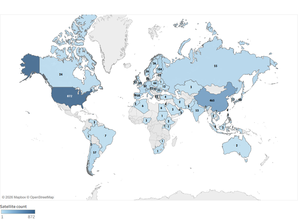
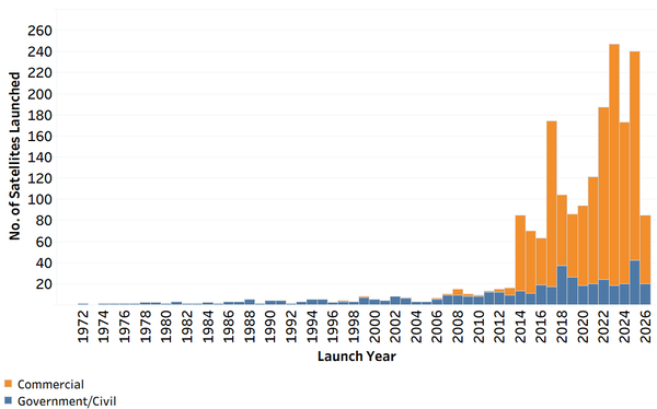
These graphic display how many satellites from what countries are included in the Online Compendium. The information about each satellite is updated as needed.
Left image: Countries with Earth Observing Satellites
Right image: Number of Commercial, Government-Civil Satellites Launched each Year
Using the Compendium
Visit the Using the Earth Observing Satellites Online Compendium webpage to learn how to best search the tool.
Citation
Please use this suggested citation when referencing the Compendium: Kropuenske, T., Clauson, J., Shaw, J., Vrabel, J., Ali, M., Ranjitkar, B., Rusten, T., and Anderson, C., 2024, Earth Observing Sensing Satellites Online Compendium: U.S. Geological Survey digital data, https://calval.cr.usgs.gov/apps/compendium.
Related

How can I learn more about remote sensing satellite missions? How can I learn more about remote sensing satellite missions?
The Earth Observing Satellites Online Compendium makes it easy to find satellite data that fits your research or project needs. This comprehensive resource covers technical details for nearly 700 past, current and future land remote sensing satellites and their sensors. You can easily filter results by criteria such as launch date, spectral bands, and orbit type, among others. Each entry provides...
Related
How can I learn more about remote sensing satellite missions? How can I learn more about remote sensing satellite missions?
The Earth Observing Satellites Online Compendium makes it easy to find satellite data that fits your research or project needs. This comprehensive resource covers technical details for nearly 700 past, current and future land remote sensing satellites and their sensors. You can easily filter results by criteria such as launch date, spectral bands, and orbit type, among others. Each entry provides...