
Using the Earth Observing Satellites Online Compendium
The Earth Observing Satellites Online Compendium contains details about past, present and future Earth observing satellites and the sensors they carry. This resource has been developed and is managed by the Requirements, Capabilities and Analysis for Earth Observation (RCA-EO) team at the USGS.
Locations of Commercial, Government-Civil Satellites
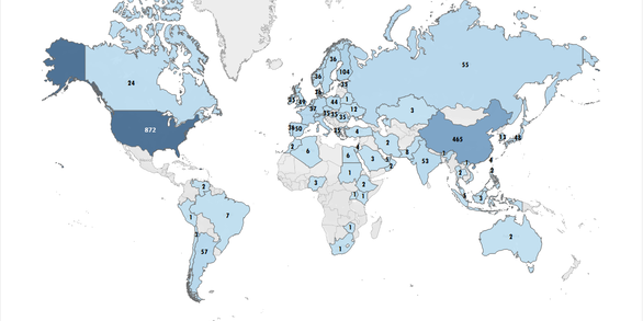
This map indicates the number of commercial and/or government/civil satellites launched by the highlighted countries.
Number of Commercial, Government-Civil Satellites
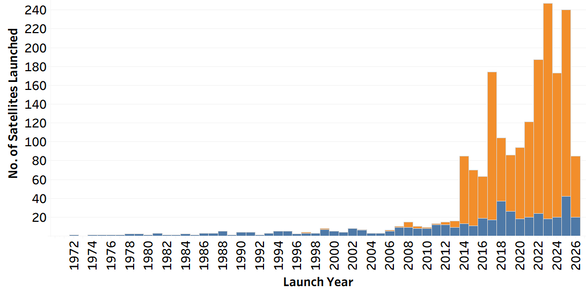
This chart shows the number of commercial and government/civil satellites launched each year since 1972.
The information contained in the Earth Observing Satellites Online Compendium is updated regularly, based on data available from satellite owners and other resources, and can be used freely, endorsing the USGS for publications. The compendium is currently going through phased development.
The contents of the Compendium is updated weekly. Please use this suggested citation when referencing the Compendium: Kropuenske, T., Clauson, J., Shaw, J., Vrabel, J., Ali, M., Ranjitkar, B., Rusten, T., and Anderson, C., 2024, Earth Observing Sensing Satellites Online Compendium: U.S. Geological Survey digital data, https://calval.cr.usgs.gov/apps/compendium.
Note: The RCA-EO team or the USGS do not warrant the accuracy, completeness, or usefulness of this information. Also, any use of trade, firm, or product names is for descriptive purposes only and does not imply endorsement by the U.S. Government.
System Requirements
Current web and mobile browsers that support JavaScript and stylesheets is recommended. Systems that have the latest version of the following browsers can utilize this compendium:
- Microsoft Edge
- Firefox
- Google Chrome
- Safari
- Default Android Browser
For the best display, it is recommended to set the resolution of screen to be at least 1024 pixel x 768 pixel resolution.
Using the Compendium
The main page of the compendium (shown below) displays satellite parameters: Name, Status, Orbit, Launch year, Country, Spectral bands, Range (nm), Radar Bands, Ground Sample Distance (GSD), Sensing Element Type, Sensor Name, Data Cost and Policy and Satellite Associations. The tool reports the satellite list by using either the search tab or the filters.

Filters
The filters shown on the left side of the page can be used to narrow down the results:
- Launch Date: Select the date range to show the satellites launched during that timeframe.
- Spectral bands (All): Select the spectral bands to show the list of satellites/sensors in these regions
- AND: Returns the list only satisfying all selected options
- OR: Returns the list satisfying any of the selected options
- Range (nm): Input the upper and lower edge of the spectral range in nanometers to return a list of satellites carrying sensors operating in the selected range. Slider can be used to adjust the upper and lower edge values.
- Reset Range: Click to reset the values to default.
- Radar Bands (All): Select the radar bands to show the list of satellites/sensors operating in the selected wavelength/frequency.
- AND: Returns the list only satisfying all selected options
- OR: Returns the list satisfying any of the selected options
- Ground Sample Distance (All): Select from a list of six GSD groups
- AND: Returns the list only satisfying all selected options
- OR: Returns the list satisfying any of the selected options
- Sensing Element Type (All): Select the desired sensor type.
- Country (All): Select country to show the satellites operated/owned by them.
- Status (All): Select the desired operational status for the satellite
- Satellite Orbit (All): Select the desired orbit (GEO, SSO and Other - includes ISS sensors)
- Data Cost: Filter the satellites/sensors based on the cost of the sensor data (Free, Cost)
- Data Policy: Filter the satellites/sensors based on the sensor data restrictions (Restricted, Unrestricted)
- Satellite Association: Select associations to show satellites owned by commercial industry versus civil/government agencies.
- Satellite Name (All): Search the satellites based on its full name or acronym. (Instrument names cannot be filtered here.)
- Reset Satellite Name: Click to remove filter values.
- Sensor Name (All): Search the sensors based on its full name or acronym
- Reset Sensor Name: Click to remove filter values
Search
The Search bar on the top left of the page can be used to enter acronyms and keywords to search the Satellite and Sensor details. For example, all satellites launched by ‘NASA’ or ‘MODIS’ sensor. Note: This search also includes the occurrence of the searched text anywhere in the compendium. This means that a search for 'NASA' will return NASA systems but also any other system that may mention the word 'NASA' within its descriptions.
Export
The export feature on the top right can be used to return a list of the filtered satellites. The export is returned as an Excel file.

Satellite Details
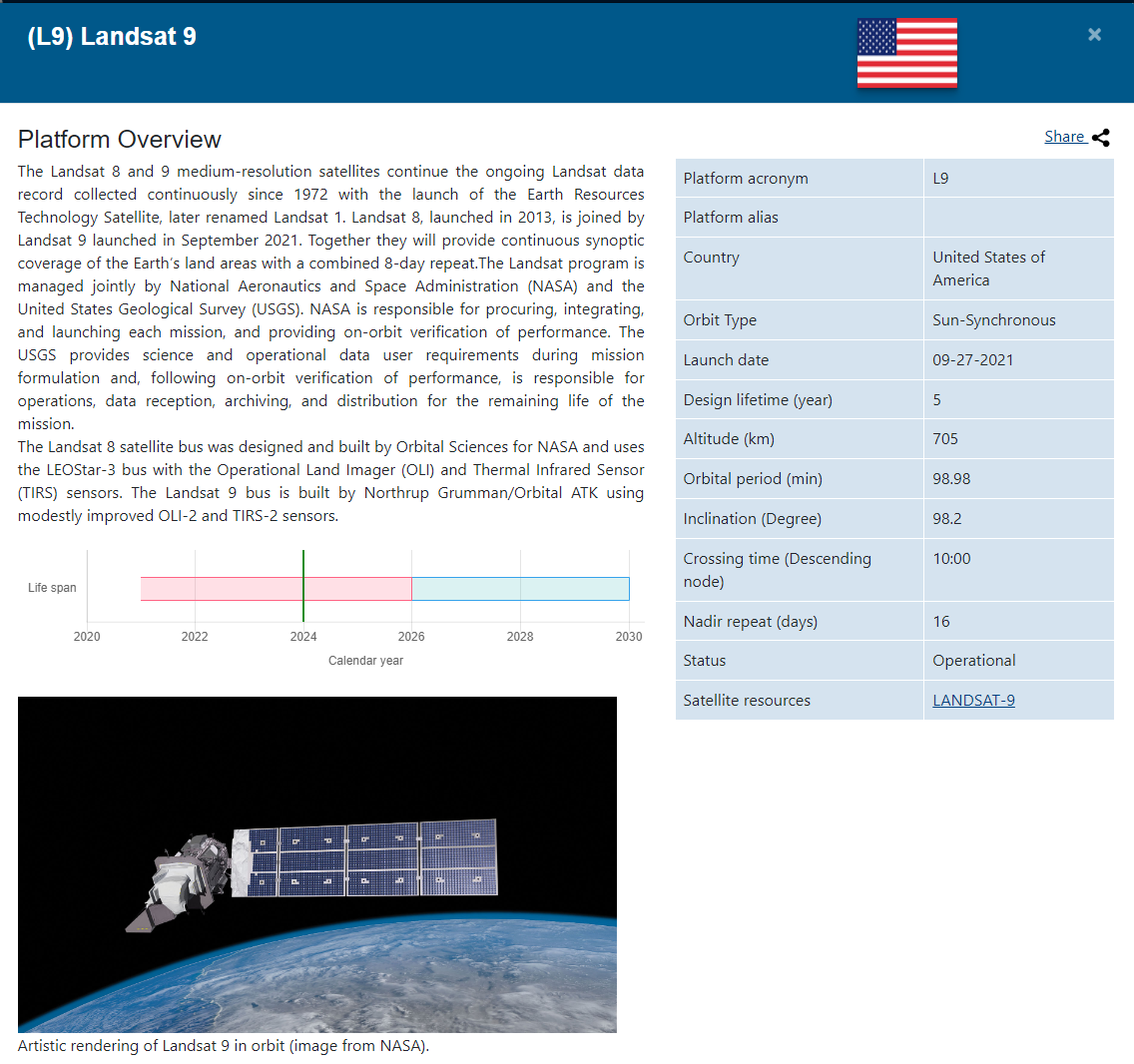
Click the magnifier symbol in the Details column to view a popup page that contains more information about the selected satellite and the sensors carried on that satellite. Each popup page contains the description of the satellite, life span, country of ownership, orbit details, sensor description, sensor specifications, spectral bandwidths, radar bands, revisit, data policy and cost, and links to additional resources.
As seen in the example image below, the red colored Life span bar indicates the design life; blue indicates optimistic end of life based on a rough estimate based on the satellite system’s history. The vertical bar represents today’s date. The colors on the spectral chart are for illustrative purposes only. The popup page can be printed or saved as a pdf by clicking the Share icon.
Contact Information
Any questions about the Earth Observing Satellites Online Compendium can be sent to eccoe@usgs.gov.