
U.S. flag

An official website of the United States government

Images

Images related to Craters of the Moon Volcanic Field.

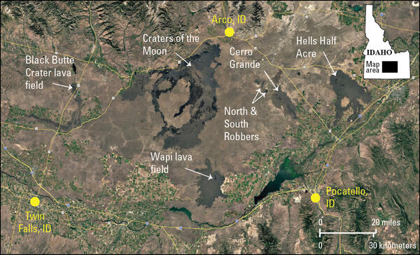
satellite image with agricultural areas and highways and isolated patches of lava flows from recent eruptions in Idaho
Satellite image of the eastern Snake River Plain, Idaho, showing locations of recent volcanic eruptions

Google Earth image of the newly proposed Idaho Volcanic Field, with recent eruptions indicated, and Craters of the Moon lava field. Major city centers surrounding the volcanic field are included to provide spatial context.

Big Southern Butte, Idaho

Big Southern Butte, Idaho.  The butte is among the largest rhyolite domes in the world and is located in the eastern Snake River Plain. Photo by James Neeley, BLM (https://flic.kr/p/CsA4TV).

Big Southern Butte, Idaho.  The butte is among the largest rhyolite domes in the world and is located in the eastern Snake River Plain. Photo by James Neeley, BLM (https://flic.kr/p/CsA4TV).

Craters of the Moon, Idaho, Landsat 7 true-color image viewed from ...

Craters of the Moon, Idaho, Landsat 7 true-color image viewed from the east. Pioneer Mountain Range along the western border. Image created by NASA EArth Observatory.

Was this page helpful?