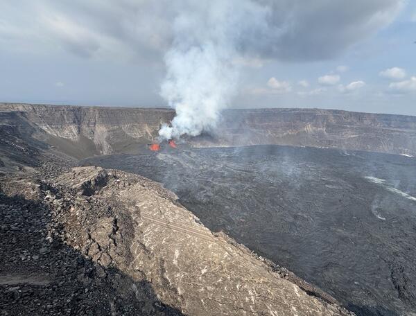
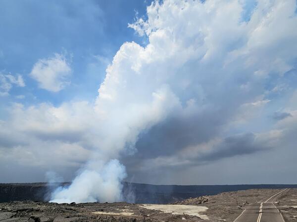
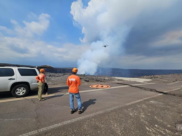
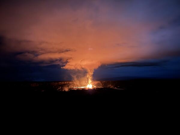
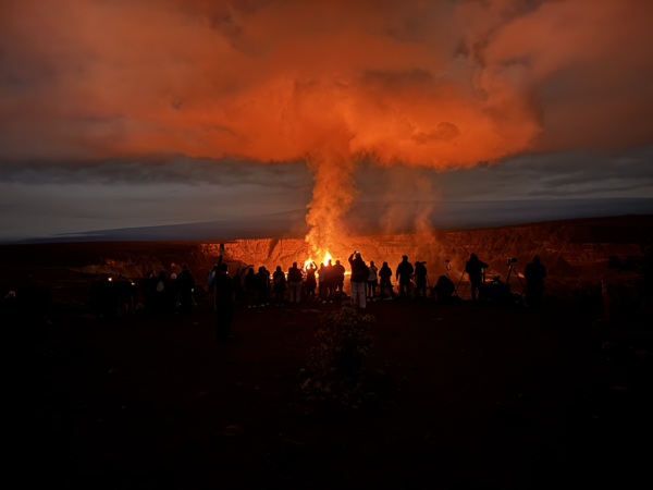
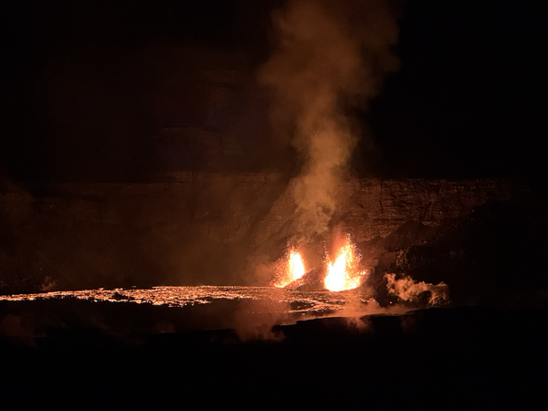
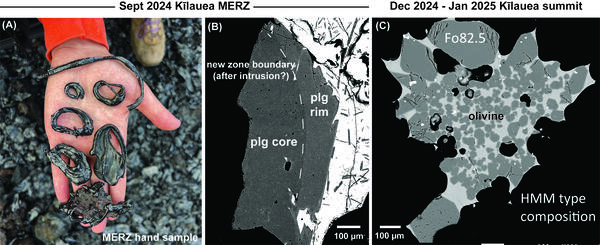
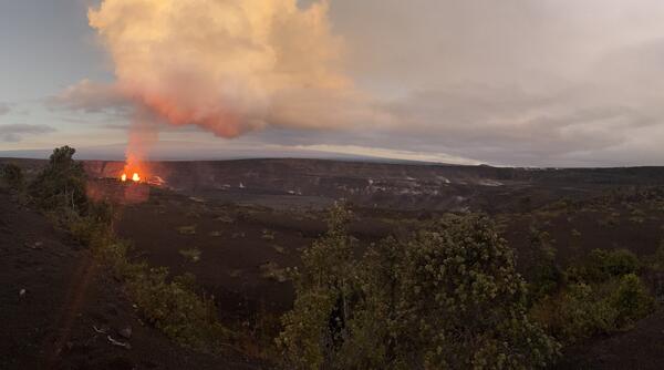
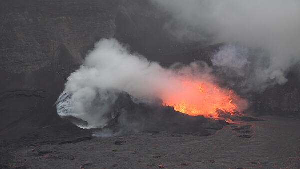
U.S. flag

An official website of the United States government

Images

Kīlauea images of eruptive activity, field work, and more.

Filter Total Items: 2915
Color photograph of vents erupting lava
December 23, 2024 - View of the new eruption at the summit of Kīlauea

This photograph, taken at approximately 4:00 a.m. HST from the Volcano House overlook in Hawaiʻi Volcanoes National Park, shows the new eruption within Kaluapele (the summit caldera).

This photograph, taken at approximately 4:00 a.m. HST from the Volcano House overlook in Hawaiʻi Volcanoes National Park, shows the new eruption within Kaluapele (the summit caldera).

Color map of temperature of crater floor with recent lava flows
December 23, 2024 — Thermal map of eruption at Kīlauea summit

This thermal map shows lava flows covering the floor of Halemaʻumaʻu crater at the summit of Kīlauea.  Fountaining was active in the southwest portion of the caldera, with flows extending east onto the downdropped block. Cooler colors (purple, black) show lower temperatures while hotter colors (orange, yellow) show higher temperatures. USGS map by M.

This thermal map shows lava flows covering the floor of Halemaʻumaʻu crater at the summit of Kīlauea.  Fountaining was active in the southwest portion of the caldera, with flows extending east onto the downdropped block. Cooler colors (purple, black) show lower temperatures while hotter colors (orange, yellow) show higher temperatures. USGS map by M.

Color photograph of volcanic plume illuminated
December 23, 2024 - Kīlauea summit eruption plume

The new Kīlauea summit eruption is occurring within a closed area of Hawai'i Volcanoes National Park. High levels of volcanic gas—primarily water vapor (H2O), carbon dioxide (CO2), and sulfur dioxide (SO2)—are the primary hazard of concern, as this hazard can have far-reaching effects down-wind.

The new Kīlauea summit eruption is occurring within a closed area of Hawai'i Volcanoes National Park. High levels of volcanic gas—primarily water vapor (H2O), carbon dioxide (CO2), and sulfur dioxide (SO2)—are the primary hazard of concern, as this hazard can have far-reaching effects down-wind.

Color photograph of molten lava lake glowing
December 23, 2024 - Kīlauea summit eruption sunrise

The lake of active lava in the summit caldera of Kīlauea glows as the sun rises. Lava has covered more than 400 acres since the eruption began at 2:20 a.m. HST this morning. USGS image by N. Deligne. 

The lake of active lava in the summit caldera of Kīlauea glows as the sun rises. Lava has covered more than 400 acres since the eruption began at 2:20 a.m. HST this morning. USGS image by N. Deligne. 

Color photograph of caldera with fresh lava flows and active eruption
December 23, 2024 - Kīlauea summit eruption overflight

USGS Hawaiian Volcano Observatory geologists conducted a monitoring overflight of the new eruption in Kīlauea summit caldera. During the overflight, which occurred at 9:30 a.m. HST, they observed lava the active lava fountains and active lava flows at the base of the caldera, which have paved more than 500 acres with new rock.

USGS Hawaiian Volcano Observatory geologists conducted a monitoring overflight of the new eruption in Kīlauea summit caldera. During the overflight, which occurred at 9:30 a.m. HST, they observed lava the active lava fountains and active lava flows at the base of the caldera, which have paved more than 500 acres with new rock.

Colro photograph of erupting vents across crater floor
December 23, 2024 - A view across new lava flows in Kīlauea summit caldera

A view across new lava flows paving the floor of Kīlauea caldera, taken during the USGS Hawaiian Volcano Observatory monitoring overflight at approximately 9:30 a.m. HST this morning. USGS photo by M. Zoeller. 

A view across new lava flows paving the floor of Kīlauea caldera, taken during the USGS Hawaiian Volcano Observatory monitoring overflight at approximately 9:30 a.m. HST this morning. USGS photo by M. Zoeller. 

Color photograph of scientist monitoring eruption
December 23, 2024 - HVO field geologists monitor eruption

USGS Hawaiian Volcano Observatory geologists observe and document the new eruption within Kīlauea summit caldera. Using a laser rangefinder, the geologists measure the distance to various points associated with the new eruption. USGS photo by M. Patrick. 

USGS Hawaiian Volcano Observatory geologists observe and document the new eruption within Kīlauea summit caldera. Using a laser rangefinder, the geologists measure the distance to various points associated with the new eruption. USGS photo by M. Patrick. 

Color photograph showing crystals under magnification
December 23, 2024 - Preparing Kīlauea's newest eruption samples

Kīlauea's newest eruption samples contain olivine - a common green mineral in Hawaiian lavas. USGS Hawaiian Volcano Observatory and University of Hawai‘i at Hilo staff are picking out the olivine crystals like this one, shown using a microscope to magnify it (the crystal is 1 mm in size, or about 0.04 inches across), to analyze their chemistry.

Kīlauea's newest eruption samples contain olivine - a common green mineral in Hawaiian lavas. USGS Hawaiian Volcano Observatory and University of Hawai‘i at Hilo staff are picking out the olivine crystals like this one, shown using a microscope to magnify it (the crystal is 1 mm in size, or about 0.04 inches across), to analyze their chemistry.

Desolate volcanic crater of gray/brown rick under a blue sky with a sloping mountain in the background
Kīlauea summit caldera from B1 camera on December 20, 2024

View of Kaluapele (Kīlauea's summit caldera) from the B1 webcam on December 20, 2024, just before the onset of the episodic lava fountaining eruption on December 23.

View of Kaluapele (Kīlauea's summit caldera) from the B1 webcam on December 20, 2024, just before the onset of the episodic lava fountaining eruption on December 23.

Color photograph of caldera floor
December 3, 2024 — Kīlauea Caldera Floor

While servicing the B1cam, HVO staff captured this telephoto view of the cones that formed on the floor of Kaluapele (Kīlauea summit caldera) during the September 2023 summit eruption. USGS photo by H. Winslow.

While servicing the B1cam, HVO staff captured this telephoto view of the cones that formed on the floor of Kaluapele (Kīlauea summit caldera) during the September 2023 summit eruption. USGS photo by H. Winslow.

Color photograph of scientist examining a webcam on the edge of a caldera
December 3, 2024 — Kīlauea Summit Webcam Maintenance

A HVO geologist inspected the KWcam enclosure for potential water entry points and found a weak seal. HVO staff will likely return in the future to make repairs to the enclosure or replace it all together. USGS photo by J. Barnett.

A HVO geologist inspected the KWcam enclosure for potential water entry points and found a weak seal. HVO staff will likely return in the future to make repairs to the enclosure or replace it all together. USGS photo by J. Barnett.

Color photograph of caldera and webcams perched on rim
December 3, 2024 — Kīlauea Caldera, Kaluapele

The KWcam on the eastern rim of Kaluapele (Kīlauea caldera) has been sending blurry images due water condensation inside the camera enclosure. On December 3rd, 2024, HVO staff visited the webcam to dry out the enclosure and search for any perforations that may be the source of the leak. USGS photo by H. Winslow.

The KWcam on the eastern rim of Kaluapele (Kīlauea caldera) has been sending blurry images due water condensation inside the camera enclosure. On December 3rd, 2024, HVO staff visited the webcam to dry out the enclosure and search for any perforations that may be the source of the leak. USGS photo by H. Winslow.

Color photograph of scientist examining a webcam on the edge of a caldera
December 3, 2024 — Kīlauea Summit Webcam Maintenance

A HVO geologist inspected the KWcam enclosure for potential water entry points and found a weak seal. HVO staff will likely return in the future to make repairs to the enclosure or replace it all together. USGS photo by J. Barnett.

A HVO geologist inspected the KWcam enclosure for potential water entry points and found a weak seal. HVO staff will likely return in the future to make repairs to the enclosure or replace it all together. USGS photo by J. Barnett.

Color photograph of scientist inspecting webcam on edge of caldera
December 3, 2024 — Kīlauea caldera camera maintenance

HVO staff also visited the B1cam on the western side of Kaluapele (Kīlauea caldera) to remove water, replace desiccant packets, and clean off spider webs on the glass which were beginning to obscure the camera's view. USGS photo by H. Winslow.

HVO staff also visited the B1cam on the western side of Kaluapele (Kīlauea caldera) to remove water, replace desiccant packets, and clean off spider webs on the glass which were beginning to obscure the camera's view. USGS photo by H. Winslow.

Color photograph of lava trees
November 25, 2024 — Kīlauea September 2024 Lava Trees

A close-up view of two tree molds beneath the surface of a September 2024 Kīlauea East Rift Zone lava flow. Gas-rich lava flows near the September 2024 fissure vents created void spaces beneath the flow surface, which partially collapsed to reveal the base of these tree molds. USGS photo by L. DeSmither, taken on November 25, 2024.

A close-up view of two tree molds beneath the surface of a September 2024 Kīlauea East Rift Zone lava flow. Gas-rich lava flows near the September 2024 fissure vents created void spaces beneath the flow surface, which partially collapsed to reveal the base of these tree molds. USGS photo by L. DeSmither, taken on November 25, 2024.

Color photograph of burned tree next to hole in lava flow
November 25, 2024 — Kīlauea September 2024 Eruption Tree Mold

A close-up view of a tree mold in a lava flow from the September 2024 Nāpau eruption. When the active lava flow came into contact with the tree, a mold was formed (black hole near center of photo). The high heat of the lava eventually burned through the base of the tree on the right side of the image causing it to fall on top of the newly emplaced lava flow.

A close-up view of a tree mold in a lava flow from the September 2024 Nāpau eruption. When the active lava flow came into contact with the tree, a mold was formed (black hole near center of photo). The high heat of the lava eventually burned through the base of the tree on the right side of the image causing it to fall on top of the newly emplaced lava flow.

Color photograph of scientist taking a cold lava sample
November 25, 2024 — Kīlauea September 2024 Eruption Sample

A USGS Hawaiian Volcano Observatory scientist uses a hammer to collect a sample from a cooled lava flow near the western end of the September 2024 Kīlauea East Rift Zone fissure system. On November 25, Hawaiian Volcano Observatory geologists visited the recent eruption area to collect lava samples and other data to further their studies of the eruption.

A USGS Hawaiian Volcano Observatory scientist uses a hammer to collect a sample from a cooled lava flow near the western end of the September 2024 Kīlauea East Rift Zone fissure system. On November 25, Hawaiian Volcano Observatory geologists visited the recent eruption area to collect lava samples and other data to further their studies of the eruption.

Color photograph of cooled lava draped over crater wall
November 25, 2024 — Kīlauea September 2024 Eruption Lava Falls

On November 25, 2024, USGS Hawaiian Volcano Observatory geologists surveyed the lava-draped west walls of Nāpau Crater. This view looks to the southwest and shows where the lava falls were vigorous enough to throw molten spatter over to the trail area. USGS photo by K. Lynn.

On November 25, 2024, USGS Hawaiian Volcano Observatory geologists surveyed the lava-draped west walls of Nāpau Crater. This view looks to the southwest and shows where the lava falls were vigorous enough to throw molten spatter over to the trail area. USGS photo by K. Lynn.

Color photograph of feature in lava flow with foot for scale
November 25, 2024 — Kīlauea September 2024 Eruption Lava Features

During field work on November 25th, 2024, HVO geologists spotted these lava "rosettes" in Nāpau Crater. They could be found on the edges of the September 15–20 lava flows, and seemed to be twirled up lava margins that spun into flower shapes as the molten flows were viscous and cooling. USGS photo by K. Lynn.

During field work on November 25th, 2024, HVO geologists spotted these lava "rosettes" in Nāpau Crater. They could be found on the edges of the September 15–20 lava flows, and seemed to be twirled up lava margins that spun into flower shapes as the molten flows were viscous and cooling. USGS photo by K. Lynn.

Color photograph of lava draped on tree
November 25, 2024 — Kīlauea September 2024 Eruption Spatter in Trees

Near the western-most fissures from the September 2024 Kīlauea East Rift Zone eruption, lava spatter is visible on the branches of a small ‘ōhi‘a tree. The lava spatter landed while it was still partially molten, causing it drape and stretch over the branches before hardening. USGS photo taken on November 25, 2024, by L. DeSmither.

Near the western-most fissures from the September 2024 Kīlauea East Rift Zone eruption, lava spatter is visible on the branches of a small ‘ōhi‘a tree. The lava spatter landed while it was still partially molten, causing it drape and stretch over the branches before hardening. USGS photo taken on November 25, 2024, by L. DeSmither.

Color photograph of sulphur deposits on tree
November 25, 2024 — Kīlauea September 2024 Eruption Sulfur Deposits

A close-up view of sulfur crystals that have grown on a fallen tree from the September 2024 Kīlauea East Rift Zone eruption. This tree fell over a lava tree cast, which is releasing hot steam and volcanic gas to form this sulfur deposit. USGS photo taken by L. DeSmither on November 25, 2024.

A close-up view of sulfur crystals that have grown on a fallen tree from the September 2024 Kīlauea East Rift Zone eruption. This tree fell over a lava tree cast, which is releasing hot steam and volcanic gas to form this sulfur deposit. USGS photo taken by L. DeSmither on November 25, 2024.

Was this page helpful?