
Kīlauea's summit lava lake in Halemaʻumaʻu is continually re-surfacing. HVO geologists monitoring the activity in the field have observed crustal foundering, in which pieces of solidified lava crust on the surface of the lava lake break and sink back into the liquid portion. USGS photo by M. Patrick on 12/31/2020.
Images
Kīlauea images of eruptive activity, field work, and more.
Filter Total Items: 3142

December 31, 2020—Kīlauea summit eruption
Kīlauea's summit lava lake in Halemaʻumaʻu is continually re-surfacing. HVO geologists monitoring the activity in the field have observed crustal foundering, in which pieces of solidified lava crust on the surface of the lava lake break and sink back into the liquid portion. USGS photo by M. Patrick on 12/31/2020.

Images of tephra from Kīlauea’s newest eruption, collected 12/21/2020
Images of tephra from Kīlauea’s newest eruption, collected 12/21/2020Left: magnified view of erupted material, including Pele’s hair and tears, as seen under a microscope (USGS Photo by K. Lynn on 12/26/2020). Middle: Zoomed in electron image of the tephra, where greyscale indicates the relative abundance of iron (Fe).

December 31, 2020—Kīlauea summit eruption
Kīlauea's summit lava lake in Halemaʻumaʻu is continually re-surfacing. HVO geologists monitoring the activity in the field have observed crustal foundering, in which pieces of solidified lava crust on the surface of the lava lake break and sink back into the liquid portion. USGS photo by M. Patrick on 12/31/2020.
Kīlauea's summit lava lake in Halemaʻumaʻu is continually re-surfacing. HVO geologists monitoring the activity in the field have observed crustal foundering, in which pieces of solidified lava crust on the surface of the lava lake break and sink back into the liquid portion. USGS photo by M. Patrick on 12/31/2020.

December 31, 2020—Kīlauea summit eruption
A channel-like feature is visible on the lava lake surface within Halemaʻumaʻu crater at Kīlauea Volcano's summit. This feature originates from the influx of lava from the western fissure, just out of view on the bottom of the photograph. USGS photo by M. Patrick on 12/31/2020.
A channel-like feature is visible on the lava lake surface within Halemaʻumaʻu crater at Kīlauea Volcano's summit. This feature originates from the influx of lava from the western fissure, just out of view on the bottom of the photograph. USGS photo by M. Patrick on 12/31/2020.

Changes in the propagation speed of ocean noise signals through Kīlauea
Changes in the propagation speed of ocean noise signals through KīlaueaThe figure shows changes in the propagation speed of ocean noise signals (red filled circles) through Kīlauea volcano from September 2020–February 2021. Positive values indicate a speedup in the propagation speed of ocean noise while negative values indicate a velocity slowdown.

December 31, 2020—Kīlauea summit eruption
The view from Kīlauea Volcano's western caldera rim shows the eastern portion of the lava lake in Halemaʻumaʻu crater. The main island is visible in the bottom of the photograph, and smaller islands can be seen above it (to the east). USGS photo by M. Patrick on 12/31/2020.
The view from Kīlauea Volcano's western caldera rim shows the eastern portion of the lava lake in Halemaʻumaʻu crater. The main island is visible in the bottom of the photograph, and smaller islands can be seen above it (to the east). USGS photo by M. Patrick on 12/31/2020.

December 31, 2020—Kīlauea summit eruption
View of the northern portion of the lava lake within Halemaʻumaʻu crater at Kīlauea Volcano's summit. Smaller islands present in the northeastern portion of the lava lake are visible. USGS photo by M. Patrick on 12/31/2020.
View of the northern portion of the lava lake within Halemaʻumaʻu crater at Kīlauea Volcano's summit. Smaller islands present in the northeastern portion of the lava lake are visible. USGS photo by M. Patrick on 12/31/2020.

December 31, 2020—Kīlauea summit eruption contour map
December 31, 2020—Kīlauea summit eruption contour mapThis map of Halema‘uma‘u at the summit of Kīlauea shows 20 m (66 ft) contour lines (dark gray) that mark locations of equal elevation above sea level (asl).
December 31, 2020—Kīlauea summit eruption contour map
December 31, 2020—Kīlauea summit eruption contour mapThis map of Halema‘uma‘u at the summit of Kīlauea shows 20 m (66 ft) contour lines (dark gray) that mark locations of equal elevation above sea level (asl).

December 31, 2020—Kīlauea summit eruption
The western fissure in Halemaʻumaʻu wall remains active. Glowing vents and a prominent spatter cone are visible in this photo. This view looks steeply down from Kīlauea's west caldera rim, and the lava lake surface is visible in the background. USGS photo by M. Patrick on 12/31/2020.
The western fissure in Halemaʻumaʻu wall remains active. Glowing vents and a prominent spatter cone are visible in this photo. This view looks steeply down from Kīlauea's west caldera rim, and the lava lake surface is visible in the background. USGS photo by M. Patrick on 12/31/2020.

December 31, 2020—Kīlauea summit eruption
View of the northern portion of the lava lake within Halemaʻumaʻu crater at Kīlauea Volcano's summit. Smaller islands present in the northeastern portion of the lava lake are visible. USGS photo by M. Patrick on 12/31/2020. USGS photo by M. Patrick on 12/31/2020.
View of the northern portion of the lava lake within Halemaʻumaʻu crater at Kīlauea Volcano's summit. Smaller islands present in the northeastern portion of the lava lake are visible. USGS photo by M. Patrick on 12/31/2020. USGS photo by M. Patrick on 12/31/2020.

Annotated photograph of the Halemaʻumaʻu eruption
Annotated eruption photograph taken at 5 p.m. HST on December 30, 2020, from the south rim of Halemaʻumaʻu, Kīlauea Volcano summit. USGS photo by K. Lynn.
Annotated eruption photograph taken at 5 p.m. HST on December 30, 2020, from the south rim of Halemaʻumaʻu, Kīlauea Volcano summit. USGS photo by K. Lynn.

Kīlauea summit eruption - Dec. 30, 2020, at 5 a.m. HST
Kīlauea summit eruption - Dec. 30, 2020, at 5 a.m. HSTHVO field crews observed activity within Halema‘uma‘u, at Kīlauea Volcano's summit, overnight from within a closed area of Hawai‘i Volcanoes National Park. The area remains closed to the public for safety reasons and HVO field crews are equipped with a range of specialized safety gear and personal protective equipment.

Kīlauea summit eruption - Dec. 29, 2020 at 5:30 a.m. HST
Kīlauea summit eruption - Dec. 29, 2020 at 5:30 a.m. HSTThis photo, taken at approximately 5:30 a.m. December 29, 2020, shows Kīlauea's ongoing summit eruption. The western vent in the wall of Halema‘uma‘u continued to erupt overnight, and the northern/eastern vent remained inactive. At approximately 3:45 a.m. HST today (Dec.

Scientist monitoring Kīlauea summit eruption on 12/29/2020
Scientist monitoring Kīlauea summit eruption on 12/29/2020HVO scientists monitor the ongoing Kīlauea summit eruption from within an area of Hawai‘i Volcanoes National Park that remains closed to the public for safety reasons. They are equipped with a range of specialized safety gear and personal protective equipment such as gas masks, helmets, gloves, and eye protection.

December 26, 2020—Kīlauea summit topographic changes
December 26, 2020—Kīlauea summit topographic changesThis graphic depicts the changes to Kīlauea Volcano's summit resulting from the eruption that began on December 20, 2020. Pre-eruption topography of Halema'uma'u crater, collected in 2019, is shown on the left and compared to the topography at the summit on December 26, 2020.

Kīlauea summit eruption - Dec. 28, 2020 at 6 p.m. HST
Kīlauea summit eruption - Dec. 28, 2020 at 6 p.m. HSTThe eruption with Halema‘uma‘u continues on the evening of December 28, 2020. This photo shows an HVO scientist making observations of Kīlauea's summit lava lake, with Mauna Loa in the background. HVO scientists have been monitoring the eruption from within an area of Hawai‘i Volcanoes National Park that remains closed to the public for safety reasons.

December 28, 2020, sunrise at Kīlauea's summit
Sunrise at the summit of Kīlauea, within Hawai‘i Volcanoes National Park, on the morning of December 28, 2020. Portions of Crater Rim Drive that down-dropped during Kīlauea's 2018 collapse events, are visible in the lower left. This area remains closed to the public due to hazardous conditions. USGS photo by C. Parcheta.
Sunrise at the summit of Kīlauea, within Hawai‘i Volcanoes National Park, on the morning of December 28, 2020. Portions of Crater Rim Drive that down-dropped during Kīlauea's 2018 collapse events, are visible in the lower left. This area remains closed to the public due to hazardous conditions. USGS photo by C. Parcheta.

HVO scientist monitors eruption
HVO scientists use a laser rangefinder to measure the distance to the lava lake surface at Kīlauea's summit.
HVO scientists use a laser rangefinder to measure the distance to the lava lake surface at Kīlauea's summit.

December 28, 2020—Kīlauea summit eruption thermal map
December 28, 2020—Kīlauea summit eruption thermal mapA helicopter overflight yesterday (Dec. 28, 2020) at approximately 10:30 AM HST allowed for aerial visual and thermal imagery to be collected of the new eruption within Halema'uma'u crater at the summit of Kīlauea Volcano. This preliminary thermal map shows that the lake area has not changed significantly since the thermal map that was made on December 26.

Kīlauea summit eruption - Dec. 28, 2020 at 5 a.m. HST
Kīlauea summit eruption - Dec. 28, 2020 at 5 a.m. HSTHVO field crews observed the continuing eruption in Halema‘uma‘u at Kīlauea's summit early this morning. Overnight, the western vent in the wall of Halema‘uma‘u continued to erupt, and the northern/eastern vent remained inactive. At approximately 4:30 a.m. HST today (Dec. 28), HVO field crews measured the lava lake as 179 m (586 ft) deep.
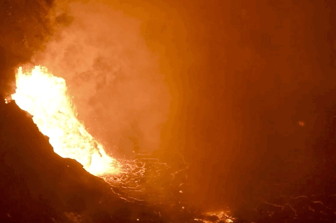
Lava Spewing from Fissure; Lavanado — Kīlauea
This animated GIF is captured from a USGS video which shows both lava erupting from a fissure and a wind vortex (lavanado) over the lava lake at Kīlauea Volcano.
This animated GIF is captured from a USGS video which shows both lava erupting from a fissure and a wind vortex (lavanado) over the lava lake at Kīlauea Volcano.