
Black streak on caldera wall (center) is about 50 m (yards) long, and white steam plume (lower right) rises from northwestern part of Halema‘uma‘u. Photo from Volcano House Hotel on July 4, 2018. The configuration of this area changed considerably after the photo was taken, as collapse continued into early August.
Images
Kīlauea images of eruptive activity, field work, and more.
Filter Total Items: 3135

Black streak of water on Kīlauea caldera wall
Black streak on caldera wall (center) is about 50 m (yards) long, and white steam plume (lower right) rises from northwestern part of Halema‘uma‘u. Photo from Volcano House Hotel on July 4, 2018. The configuration of this area changed considerably after the photo was taken, as collapse continued into early August.

Kīlauea Volcano — Flows Near Kapoho Ag. and Beach Lots
Kīlauea Volcano — Flows Near Kapoho Ag. and Beach LotsNear the coast, the northern margin of the flow field is still oozing pasty lava at several points in the area of Kapoho Agricultural and Beach Lots.
Kīlauea Volcano — Flows Near Kapoho Ag. and Beach Lots
Kīlauea Volcano — Flows Near Kapoho Ag. and Beach LotsNear the coast, the northern margin of the flow field is still oozing pasty lava at several points in the area of Kapoho Agricultural and Beach Lots.

Kīlauea Volcano — Fissure 8 at Night
USGS Unmanned Aircraft Systems image of fissure 8 looking east.
USGS Unmanned Aircraft Systems image of fissure 8 looking east.

Kīlauea Volcano — Scientist Observing Fissure 8
USGS scientist observes the glow of fissure 8 fountain and channel within Leilani Estates. Steam rises from cracks and hot spots within the tephra deposit surrounding the cone.
USGS scientist observes the glow of fissure 8 fountain and channel within Leilani Estates. Steam rises from cracks and hot spots within the tephra deposit surrounding the cone.
Kīlauea Volcano — Animation of Summit Subsidence
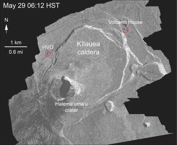
This animated GIF shows a sequence of radar amplitude images that were acquired by the Agenzia Spaziale Italiana CosmoSkyMed satellite system. The images illustrate changes to the caldera area of Kīlauea Volcano that occurred between May 5 and July 4 at about 6:00 a.m. HST.
This animated GIF shows a sequence of radar amplitude images that were acquired by the Agenzia Spaziale Italiana CosmoSkyMed satellite system. The images illustrate changes to the caldera area of Kīlauea Volcano that occurred between May 5 and July 4 at about 6:00 a.m. HST.

Kīlauea Volcano — Lava Flowing from Fissure 8
Lava within the fissure 8 cone roils and churns where it eupts from the vent and flows rapidly down the well-established channel. This image was captured via a Mavic Pro drone courtesy of the DOI/USGS Unmanned Aircraft Systems team.
Lava within the fissure 8 cone roils and churns where it eupts from the vent and flows rapidly down the well-established channel. This image was captured via a Mavic Pro drone courtesy of the DOI/USGS Unmanned Aircraft Systems team.

Kīlauea Volcano — Lava Channel Bend
The lava channel from fissure 8 jumped its banks near Kapoho Crater where the channel makes a 90 degree bend. The flow within the channel was diverted around a constricted area and joined the channel again "downstream" to the south (left).
The lava channel from fissure 8 jumped its banks near Kapoho Crater where the channel makes a 90 degree bend. The flow within the channel was diverted around a constricted area and joined the channel again "downstream" to the south (left).

Kīlauea Volcano — Sunrise at Haleam`uma`u Crater
Sunrise view of Halema‘uma‘u crater as seen from the USGS observation point from Volcano House in Hawai‘i Volcanoes National Park.
Sunrise view of Halema‘uma‘u crater as seen from the USGS observation point from Volcano House in Hawai‘i Volcanoes National Park.

Kīlauea Volcano — Fissure 8 Flow at Night
During the overnight hours, the UAS (Unoccupied Aircraft Systems) team flew sections of the lower East Rift Zone, monitoring fissure 8 activity and reports of small overflows from the lava channel.
During the overnight hours, the UAS (Unoccupied Aircraft Systems) team flew sections of the lower East Rift Zone, monitoring fissure 8 activity and reports of small overflows from the lava channel.

Kīlauea Volcano — Sunrise at Halema`uma`u Crater
Inward slumping of Halema‘uma‘u continues in response to ongoing subsidence at Kīlauea Volcano's summit. This image, taken from a temporary observation post located at Volcano House, shows steep walls on the western side of the crater and sloping piles of rubble from rockfall events.
Inward slumping of Halema‘uma‘u continues in response to ongoing subsidence at Kīlauea Volcano's summit. This image, taken from a temporary observation post located at Volcano House, shows steep walls on the western side of the crater and sloping piles of rubble from rockfall events.

Kīlauea Volcano — Evolution of a Blocked Channel (Part 2)
Kīlauea Volcano — Evolution of a Blocked Channel (Part 2)Evolution of a blocked channel, image 2: While observing this area of the fissure 8 lava channel near Kapoho cone during the morning overflight, geologists witnesed an "apartment-building-sized" blockage within the channel give way and be pushed down stream by the pressurized lava behind.

Kīlauea Volcano — Evolution of a Blocked Channel (Part 1)
Kīlauea Volcano — Evolution of a Blocked Channel (Part 1)Evolution of a blocked channel, photo 1. A blockage of rafted material within the lava channel causes lava to flow over its banks near the Kapoho cone. In this section of the lava channel a cold lava flow from the 1960 eruption forms a barrier on the north side, which initially directed the channel to the southeast.

Kīlauea Volcano — Fissure 8 Lava Flow
Fissure 8 and the upper lava channel, viewed from the early morning helicopter overflight of the lower East Rift Zone. Recent heavy rains have soaked into the still-warm tephra and the moisture rises as steam (right side of lava channel).
Fissure 8 and the upper lava channel, viewed from the early morning helicopter overflight of the lower East Rift Zone. Recent heavy rains have soaked into the still-warm tephra and the moisture rises as steam (right side of lava channel).

Kīlauea Volcano — Geologist Making Observations of Fissure 8
Kīlauea Volcano — Geologist Making Observations of Fissure 8Fisheye lens photograph of a USGS geologist making observations of the fissure 8 lava channel at sunset July 3, 2018. The field crew is at a high point overlooking the channel near where it makes a 90 degree turn around Kapoho Crater and flows south.

Kīlauea Volcano — Drone Over Lava Channel
USGS Mavic Pro drone image of the fissure 8 lava channel looking toward the vent. Overflows can be seen as incandescent spots beyond the channel margins. Drone flights and resultant imagery help scientists better identify areas of channel overflows and active flow advancement.
USGS Mavic Pro drone image of the fissure 8 lava channel looking toward the vent. Overflows can be seen as incandescent spots beyond the channel margins. Drone flights and resultant imagery help scientists better identify areas of channel overflows and active flow advancement.

Kīlauea Volcano — Overfows
Close up image of overflows from the fissure 8 lava channel. Photograph taken during the morning overflight.
Close up image of overflows from the fissure 8 lava channel. Photograph taken during the morning overflight.

Kīlauea Volcano — Ocean Entry
The ocean entry being fed by a crusted over channel has fewer tiny ooze-out channels than yesterday spilling into the water. One larger ooze-out channel making dominant entry plume at the northern end of the broad ocean entry.
The ocean entry being fed by a crusted over channel has fewer tiny ooze-out channels than yesterday spilling into the water. One larger ooze-out channel making dominant entry plume at the northern end of the broad ocean entry.

Kīlauea Volcano — Fissure 8 Channel (Annotated)
Annotated drone image of Kīlauea Volcano's lower East Rift Zone fissure 8 lava channel. Image captured near Kapoho Crater looking east toward the ocean entry. Incandescent flow margin is more easily identified in the dark - specifically here in the area of Kapoho Beach Lots.
Annotated drone image of Kīlauea Volcano's lower East Rift Zone fissure 8 lava channel. Image captured near Kapoho Crater looking east toward the ocean entry. Incandescent flow margin is more easily identified in the dark - specifically here in the area of Kapoho Beach Lots.

Kīlauea Volcano — Lava at Kapoho Beach Lots
At the coast, the northern margin of the flow field is still oozing pasty lava at several points in the area of Kapoho Beach Lots.
At the coast, the northern margin of the flow field is still oozing pasty lava at several points in the area of Kapoho Beach Lots.

Kīlauea Volcano — Open Lava Channels
Fountains from Fissure 8 spatter cone continue to supply lava to the open channel with intermittent small, short-lived overflows. Overflows appear as lighter gray to silver areas on the margins of the channel.
Fountains from Fissure 8 spatter cone continue to supply lava to the open channel with intermittent small, short-lived overflows. Overflows appear as lighter gray to silver areas on the margins of the channel.

Kīlauea Volcano — Lava Channels from Fissure 8
Lava from fissure 8 is fed into a channel that travels about 13 km (8 mi) to the sea. A plumemarks the location of fissure 8, visible in the upper right; a small plume in the upper center marks the location of fissure 22.
Lava from fissure 8 is fed into a channel that travels about 13 km (8 mi) to the sea. A plumemarks the location of fissure 8, visible in the upper right; a small plume in the upper center marks the location of fissure 22.