
An aerial view of the Kapoho ocean entry, as of 6:30 a.m. HST today, shows the extent of the lava delta, now about 200 acres in size, that has formed over the past six days (lava first entered the ocean on the night of June 3).
Images
Kīlauea images of eruptive activity, field work, and more.
Filter Total Items: 3194

Kīlauea Volcano — Kapoho Ocean Entry
An aerial view of the Kapoho ocean entry, as of 6:30 a.m. HST today, shows the extent of the lava delta, now about 200 acres in size, that has formed over the past six days (lava first entered the ocean on the night of June 3).

Kīlauea Volcano — Halema`uma`u Cracking and Slumping
Kīlauea Volcano — Halema`uma`u Cracking and SlumpingCracking and slumping of the Halema‘uma‘u crater walls are clearly evident in this aerial view captured during HVO's overflight of Kīlauea's summit this morning. Steam plumes have been rising from within the crater, as well as from cracks adjacent to the crater.

Kīlauea Volcano — Halema‘uma‘u Cracking
Another aerial view showing prominent cracking around Halema‘uma‘u from the ongoing subsidence at Kīlauea's summit. The steaming cracks in the background have been observed for several days.
Another aerial view showing prominent cracking around Halema‘uma‘u from the ongoing subsidence at Kīlauea's summit. The steaming cracks in the background have been observed for several days.

Kīlauea Volcano — Fissure 8 Lava Channel
Fissure 8 and lava channel in the lower East Rift Zone of Kīlauea Volcano during this afternoon's overflight, with no apparent slowing in the eruption rate. The lava channel remained incandescent all the way around Kapoho Crater before entering the ocean.
Fissure 8 and lava channel in the lower East Rift Zone of Kīlauea Volcano during this afternoon's overflight, with no apparent slowing in the eruption rate. The lava channel remained incandescent all the way around Kapoho Crater before entering the ocean.

Kīlauea Volcano — Fissure 8 Lava Fountain

Kīlauea LERZ lava flows and fissures, June 9, 10:00 a.m.
Kīlauea LERZ lava flows and fissures, June 9, 10:00 a.m.Map as of 10:00 a.m. HST, June 9, 2018. The fissure 8 flow has created a lava delta approximately 200 acres in size, filling Kapoho Bay and shallow reefs along the nearby coastline.
Kīlauea LERZ lava flows and fissures, June 9, 10:00 a.m.
Kīlauea LERZ lava flows and fissures, June 9, 10:00 a.m.Map as of 10:00 a.m. HST, June 9, 2018. The fissure 8 flow has created a lava delta approximately 200 acres in size, filling Kapoho Bay and shallow reefs along the nearby coastline.

Kīlauea Volcano — Kapoho Bay and Vacationland
HVO's early morning helicopter overflight of Kīlauea's lower East Rift Zone showed that lava continues to flow into the ocean in the vicinity of Kapoho Bay and Vacationland.
HVO's early morning helicopter overflight of Kīlauea's lower East Rift Zone showed that lava continues to flow into the ocean in the vicinity of Kapoho Bay and Vacationland.

Kīlauea Volcano — Lava Fountaining (Fissure 8)
Around 3:00 a.m. HST today (June 8), lava fountains erupting from fissure 8 on Kīlauea Volcano's Lower East Rift Zone were reaching heights of 180–220 feet.
Around 3:00 a.m. HST today (June 8), lava fountains erupting from fissure 8 on Kīlauea Volcano's Lower East Rift Zone were reaching heights of 180–220 feet.

Kīlauea LERZ lava flows and fissures, June 8, 12:00 p.m.
Kīlauea LERZ lava flows and fissures, June 8, 12:00 p.m.Map as of 12:00 p.m. (noon) HST, June 8, 2018. Given the dynamic nature of Kīlauea's lower East Rift Zone eruption, with changing vent locations, fissures starting and stopping, and varying rates of lava effusion, map details shown here are accurate as of the date/time noted. Shaded purple areas indicate lava flows erupted in 1840, 1955, 1960, and 2014-2015.

Kīlauea Volcano — Summit Outgassing
Outgassing from Halema‘uma‘u produced twin pillars that rose in the still morning air and merged into a towering cap above the summit of Kīlauea just after sunrise.
Outgassing from Halema‘uma‘u produced twin pillars that rose in the still morning air and merged into a towering cap above the summit of Kīlauea just after sunrise.

Kīlauea Volcano — Summit Pluming
Dramatic changes at Halema‘uma‘u could be seen through gases rising from the crater during HVO's overflight of the summit this morning at 10 a.m. HST. The view here looks to the southwest, with the former overlook parking lot barely visible to the left of the gas plume.
Dramatic changes at Halema‘uma‘u could be seen through gases rising from the crater during HVO's overflight of the summit this morning at 10 a.m. HST. The view here looks to the southwest, with the former overlook parking lot barely visible to the left of the gas plume.

Kīlauea Volcano — Kapoho Bay Laze
The Kapoho ocean entry (as of 6:30 a.m.

Kīlauea Volcano — Laze Plume
Lava enters the ocean in the vicinity of Vacationland at 7 a.m. HST. The ocean entry produces a white plume called "laze," which drifts downwind. Laze is composed of steam, hydrochloric acid and tiny volcanic glass particles, which can irritate the lungs, eyes and skin.
Lava enters the ocean in the vicinity of Vacationland at 7 a.m. HST. The ocean entry produces a white plume called "laze," which drifts downwind. Laze is composed of steam, hydrochloric acid and tiny volcanic glass particles, which can irritate the lungs, eyes and skin.

Kīlauea Volcano — Lava Fountain and Flow (Fissure 8)
Kīlauea Volcano — Lava Fountain and Flow (Fissure 8)View of the fissure 8 lava fountain and lava channel that travels to the ocean, a distance of about 12.5 km (7.8 mi). Photo taken during this morning's overflight at about 6:30 a.m. HST.
Kīlauea Volcano — Lava Fountain and Flow (Fissure 8)
Kīlauea Volcano — Lava Fountain and Flow (Fissure 8)View of the fissure 8 lava fountain and lava channel that travels to the ocean, a distance of about 12.5 km (7.8 mi). Photo taken during this morning's overflight at about 6:30 a.m. HST.

Kīlauea Volcano — Large Crack in Parking Lot
An even larger crack, shown here, arcs across the parking lot and bounds one of the large blocks mentioned above.
An even larger crack, shown here, arcs across the parking lot and bounds one of the large blocks mentioned above.

Kīlauea Volcano — Crack in Parking Lot
The median between two areas of the parking lot has been warped and broken by cracks. Ash accumulation in the parking area was generally not more than 4 cm (1.5 in) thick.
The median between two areas of the parking lot has been warped and broken by cracks. Ash accumulation in the parking area was generally not more than 4 cm (1.5 in) thick.
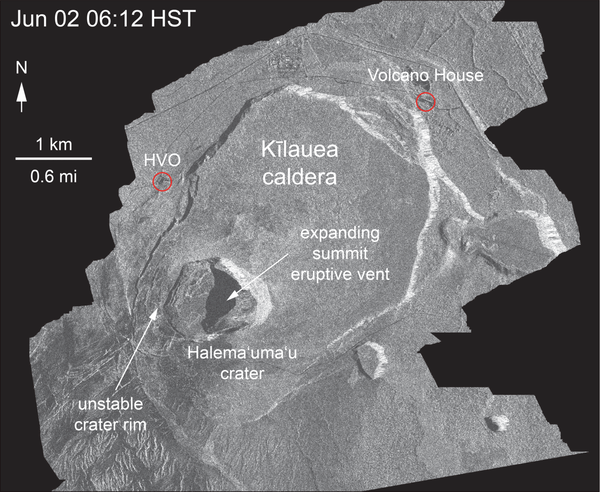
Kīlauea Volcano — Satellite Radar of Crater Slumping
Kīlauea Volcano — Satellite Radar of Crater SlumpingThis animated GIF shows a sequence of radar amplitude images that were acquired by the Italian Space Agency's Cosmo-SkyMed satellite system. The images illustrate changes to the caldera area of Kīlauea Volcano that occurred between May 5 and June 6 at 6:00 a.m. HST.

Kīlauea Volcano — Crack on Crater Rim Drive
Crack on Crater Rim Drive just east of the parking lot, with the National Park sign indicating "Halema‘uma‘u" at right. This crack shows 42 cm (16.5 in) of right lateral offset—as measured by fitting the center stripe on the road back together)—and was about 25 cm (10 in) wide.
Crack on Crater Rim Drive just east of the parking lot, with the National Park sign indicating "Halema‘uma‘u" at right. This crack shows 42 cm (16.5 in) of right lateral offset—as measured by fitting the center stripe on the road back together)—and was about 25 cm (10 in) wide.

Kīlauea Volcano — Ballistic Blocks
With careful consideration and planning to avoid ongoing volcanic hazards as much as possible, an HVO scientist who has been studying the behavior of Kīlauea's summit for decades, briefly visited the parking area for the former Halema‘uma‘u overlook (closed since 2008) on June 5 to make direct observations of and gather data from the effects of recent explosions wit
With careful consideration and planning to avoid ongoing volcanic hazards as much as possible, an HVO scientist who has been studying the behavior of Kīlauea's summit for decades, briefly visited the parking area for the former Halema‘uma‘u overlook (closed since 2008) on June 5 to make direct observations of and gather data from the effects of recent explosions wit

Kīlauea Volcano — Halema`uma`u Parking Lot
The Halema‘uma‘u parking lot is sliced into blocks by cracks. These cracks, first noted in a very early stage on May 13, now are the dominant features of the parking lot. The cracks, which are circumferential to Halema‘uma‘u, warp and offset the pavement and curbing, as seen here. The crack responsible for warping this curbstone is visible on both sides of it.
The Halema‘uma‘u parking lot is sliced into blocks by cracks. These cracks, first noted in a very early stage on May 13, now are the dominant features of the parking lot. The cracks, which are circumferential to Halema‘uma‘u, warp and offset the pavement and curbing, as seen here. The crack responsible for warping this curbstone is visible on both sides of it.

Another explosion at the summit of Kīlauea
On June 6, at 4:07 p.m. HST, an explosion within Halema‘uma‘u sent an ash and gas plume to a height of about 10,000 feet above sea level. The explosion released energy equivalent to that of a magnitude-5.6 earthquake; a result of the explosion-related energy release was ground shaking felt throughout the summit area.
On June 6, at 4:07 p.m. HST, an explosion within Halema‘uma‘u sent an ash and gas plume to a height of about 10,000 feet above sea level. The explosion released energy equivalent to that of a magnitude-5.6 earthquake; a result of the explosion-related energy release was ground shaking felt throughout the summit area.