



Fissure 8 lava fountain during this morning's overflight of the lower East Rift Zone.
Images
Kīlauea images of eruptive activity, field work, and more.
Filter Total Items: 3249

Kīlauea Volcano — Fissure 8
Fissure 8 lava fountain during this morning's overflight of the lower East Rift Zone.

Kīlauea Volcano — Fissure 8
Fissure 8 fountains to heights of 130-140 ft. The lava spatter chills and the fragments are building a cone on the downwind side, now nearly as tall as the fountain itself.
Fissure 8 fountains to heights of 130-140 ft. The lava spatter chills and the fragments are building a cone on the downwind side, now nearly as tall as the fountain itself.

Kīlauea Volcano — Fissure 8
Fissure 8 lava fountains continue to reach heights of 40-45 m (130-150 ft) from within the growing cone of cinder and spatter, which
Fissure 8 lava fountains continue to reach heights of 40-45 m (130-150 ft) from within the growing cone of cinder and spatter, which

Kīlauea Volcano — Kapoho New Land
Closer view of new land in the Kapoho area. The new coastline, following the ragged lava-ocean interface, is approximately 2.1 km (1.3 mi) in length. The white steam/laze plume marks the location of the most active lava entry site during the morning overflight.
Closer view of new land in the Kapoho area. The new coastline, following the ragged lava-ocean interface, is approximately 2.1 km (1.3 mi) in length. The white steam/laze plume marks the location of the most active lava entry site during the morning overflight.

Kīlauea Volcano — Ocean Entry Laze Plume

Kīlauea LERZ lava flows and fissures, June 13, 10:00 a.m.
Kīlauea LERZ lava flows and fissures, June 13, 10:00 a.m.Map as of 10:00 a.m. HST, June 13, 2018. Given the dynamic nature of Kīlauea's lower East Rift Zone eruption, with changing vent locations, fissures starting and stopping, and varying rates of lava effusion, map details shown here are accurate as of the date/time noted. Shaded purple areas indicate lava flows erupted in 1840, 1955, 1960, and 2014-2015.
Kīlauea LERZ lava flows and fissures, June 13, 10:00 a.m.
Kīlauea LERZ lava flows and fissures, June 13, 10:00 a.m.Map as of 10:00 a.m. HST, June 13, 2018. Given the dynamic nature of Kīlauea's lower East Rift Zone eruption, with changing vent locations, fissures starting and stopping, and varying rates of lava effusion, map details shown here are accurate as of the date/time noted. Shaded purple areas indicate lava flows erupted in 1840, 1955, 1960, and 2014-2015.

Kīlauea Volcano — Ocean Entry

Kīlauea Volcano — Halema‘uma‘u Crater
Events at the summit of Kīlauea over the past few weeks have dramatically reshaped Halema‘uma‘u, shown here in this aerial view, which looks west across the crater. The obvious flat surface (photo center) is the former Halema‘uma‘u crater floor, which has subsided at least 100 m (about 300 ft) during the past couple weeks.
Events at the summit of Kīlauea over the past few weeks have dramatically reshaped Halema‘uma‘u, shown here in this aerial view, which looks west across the crater. The obvious flat surface (photo center) is the former Halema‘uma‘u crater floor, which has subsided at least 100 m (about 300 ft) during the past couple weeks.

Kīlauea Volcano — Multiple Ocean Entries
The south side of the ocean entry was most active today, with many small streams of lava and corresponding steam plumes spread along a fairly broad section of the southern part of the delta. USGS image taken June 12, 2018, around 6:13 AM.
The south side of the ocean entry was most active today, with many small streams of lava and corresponding steam plumes spread along a fairly broad section of the southern part of the delta. USGS image taken June 12, 2018, around 6:13 AM.

Kīlauea Volcano — Halema`uma`u Crater Cracks
A closer view of the cracks cutting across the parking lot for the former Halema‘uma‘u visitor overlook (closed since 2008, when an active vent opened within the crater). Additional photos—ground views—of the parking lot cracks were posted on June 7 and 11.
A closer view of the cracks cutting across the parking lot for the former Halema‘uma‘u visitor overlook (closed since 2008, when an active vent opened within the crater). Additional photos—ground views—of the parking lot cracks were posted on June 7 and 11.

Kīlauea summit
Events at the summit of Kīlauea over the past few weeks have dramatically reshaped Halema‘uma‘u, shown here in this aerial view, which looks west across the crater. The obvious flat surface (photo center) is the former Halema‘uma‘u crater floor, which has subsided at least 100 m (about 300 ft) during the past couple weeks.
Events at the summit of Kīlauea over the past few weeks have dramatically reshaped Halema‘uma‘u, shown here in this aerial view, which looks west across the crater. The obvious flat surface (photo center) is the former Halema‘uma‘u crater floor, which has subsided at least 100 m (about 300 ft) during the past couple weeks.

Kīlauea Volcano —
Image taken during the June 12, 2018, morning helicopter overflight of fissure 8 and the lava channel.
Image taken during the June 12, 2018, morning helicopter overflight of fissure 8 and the lava channel.

Kīlauea Volcano — Kapoho Bay
Aerial view of the ocean entry at Kapoho, where a lava delta about 250 acres in size is filling the bay. USGS image taken June 12, 2018, around 6:50 a.m. HST.
Aerial view of the ocean entry at Kapoho, where a lava delta about 250 acres in size is filling the bay. USGS image taken June 12, 2018, around 6:50 a.m. HST.

Kīlauea Volcano — Fissure 8 Lava Fountain

Kīlauea Volcano — Braided Lava Channels
Fissure 8 (fountain visible in distance) feeds lava into an active braided channel that flows about 8 miles (north, then east) to the ocean entry in Kapoho Bay. USGS image taken June 12, 2018, around 6:50 a.m. HST.
Fissure 8 (fountain visible in distance) feeds lava into an active braided channel that flows about 8 miles (north, then east) to the ocean entry in Kapoho Bay. USGS image taken June 12, 2018, around 6:50 a.m. HST.

Kīlauea Volcano — Cracked Road at Summit
This 'warped-curb' crack, the largest in the parking area for the former Halema‘uma‘u overlook (closed since 2008), is one of many that have sliced the parking area into slices. Ballistics (blocks of solid rock) strewn across the area are visible in the foreground.
This 'warped-curb' crack, the largest in the parking area for the former Halema‘uma‘u overlook (closed since 2008), is one of many that have sliced the parking area into slices. Ballistics (blocks of solid rock) strewn across the area are visible in the foreground.

Kīlauea Volcano — Lava Channels (Fissure 8)
Aerial view of the fissure 8 lava channel on Kīlauea Volcano's lower East Rift Zone in the vicinity of the Kapoho cone, with fissure 8 fountains visible in the distance (upper left).
Aerial view of the fissure 8 lava channel on Kīlauea Volcano's lower East Rift Zone in the vicinity of the Kapoho cone, with fissure 8 fountains visible in the distance (upper left).

Kīlauea LERZ lava flows and fissures, June 11, 3:00 p.m.
Kīlauea LERZ lava flows and fissures, June 11, 3:00 p.m.Map as of 3:00 p.m. HST, June 11, 2018. Given the dynamic nature of Kīlauea's lower East Rift Zone eruption, with changing vent locations, fissures starting and stopping, and varying rates of lava effusion, map details shown here are accurate as of the date/time noted. Shaded purple areas indicate lava flows erupted in 1840, 1955, 1960, and 2014-2015.
Kīlauea LERZ lava flows and fissures, June 11, 3:00 p.m.
Kīlauea LERZ lava flows and fissures, June 11, 3:00 p.m.Map as of 3:00 p.m. HST, June 11, 2018. Given the dynamic nature of Kīlauea's lower East Rift Zone eruption, with changing vent locations, fissures starting and stopping, and varying rates of lava effusion, map details shown here are accurate as of the date/time noted. Shaded purple areas indicate lava flows erupted in 1840, 1955, 1960, and 2014-2015.
Kīlauea summit activity
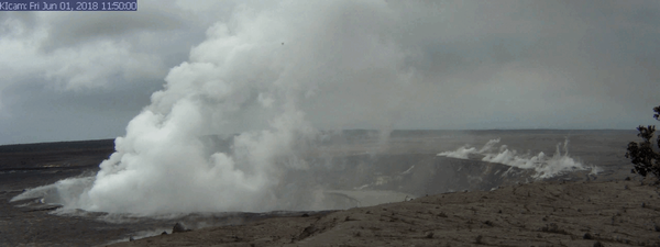
A series of wide-angle webcam images, captured by a camera in HVO's observation tower (https://volcanoes.usgs.gov/volcanoes/kilauea/multimedia_webcams.html) between June 1 and June 10, 2018, show ongoing subsidence around Halema‘uma‘u at the summit of Kīlauea in this animated GIF.
A series of wide-angle webcam images, captured by a camera in HVO's observation tower (https://volcanoes.usgs.gov/volcanoes/kilauea/multimedia_webcams.html) between June 1 and June 10, 2018, show ongoing subsidence around Halema‘uma‘u at the summit of Kīlauea in this animated GIF.

Kīlauea summit activity
Another explosion occurred at Halema‘uma‘u at 12:51 a.m. HST today, releasing energy equivalent to a magnitude-5.3 earthquake. Following the explosion, summit activity consisted mostly of passive degassing at Halema‘uma‘u, similar to what is shown in this image taken mid-morning.
Another explosion occurred at Halema‘uma‘u at 12:51 a.m. HST today, releasing energy equivalent to a magnitude-5.3 earthquake. Following the explosion, summit activity consisted mostly of passive degassing at Halema‘uma‘u, similar to what is shown in this image taken mid-morning.

Kīlauea Volcano — Fissure 8 Eruption