U.S. flag

An official website of the United States government

Images

Kīlauea images of eruptive activity, field work, and more.

Filter Total Items: 3249
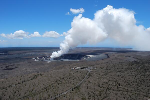
At Kīlauea, when the lava column drops below the water table, groun...

At Kīlauea, when the lava column drops below the water table, groundwater may come into contact with with magma or hot rocks, causing violent steam explosions.

Kīlauea East Rift Zone Eruption Map: December 27, 2011...
Kīlauea ERZ Eruption Map: Dec. 27, 2012

Map showing the extent of lava flows erupted during Kīlauea's ongoing east rift zone eruption and labeled with the years in which they were active.

Map showing the extent of lava flows erupted during Kīlauea's ongoing east rift zone eruption and labeled with the years in which they were active.

Kīlauea's Volcanic Gases and Their Environmental Impacts...
Kīlauea's Volcanic Gases and Their Environmental Impacts

Gas emissions from the crater of Pu‘u ‘Ō‘ō on Kīlauea's east rift zone (foreground) and the summit vent in Halema‘uma‘uCrater (background, just below the clouds) create volcanic pollution that affects the air quality of downwind communities. USGS photo by Tim Orr.

Gas emissions from the crater of Pu‘u ‘Ō‘ō on Kīlauea's east rift zone (foreground) and the summit vent in Halema‘uma‘uCrater (background, just below the clouds) create volcanic pollution that affects the air quality of downwind communities. USGS photo by Tim Orr.

Kīlauea East Rift Zone Eruption Map: December 13, 2011...
Kīlauea ERZ Eruption Map: Dec. 13, 2012

Map showing the extent of lava flows erupted during Kīlauea's ongoing east rift zone eruption and labeled with the years in which they were active.

Map showing the extent of lava flows erupted during Kīlauea's ongoing east rift zone eruption and labeled with the years in which they were active.

Kīlauea East Rift Zone Eruption Map: December 2, 2011...
Kīlauea ERZ Eruption Map: Dec. 2, 2012

Map showing the extent of lava flows erupted during Kīlauea's ongoing east rift zone eruption and labeled with the years in which they were active.

Map showing the extent of lava flows erupted during Kīlauea's ongoing east rift zone eruption and labeled with the years in which they were active.

Kīlauea East Rift Zone Eruption Map: November 21, 2011...
Kīlauea ERZ Eruption Map: Nov. 21, 2012

Map showing the extent of lava flows erupted during Kīlauea's ongoing east rift zone eruption and labeled with the years in which they were active.

Map showing the extent of lava flows erupted during Kīlauea's ongoing east rift zone eruption and labeled with the years in which they were active.

Kīlauea East Rift Zone Eruption Map: November 10, 2011...
Kīlauea ERZ Eruption Map: Nov. 10, 2012

Map showing the extent of lava flows erupted during Kīlauea's ongoing east rift zone eruption and labeled with the years in which they were active.

Map showing the extent of lava flows erupted during Kīlauea's ongoing east rift zone eruption and labeled with the years in which they were active.

Kīlauea East Rift Zone Eruption Map: November 3, 2011...
Kīlauea ERZ Eruption Map: Nov. 3, 2012

Map showing the extent of lava flows erupted during Kīlauea's ongoing east rift zone eruption and labeled with the years in which they were active.

Map showing the extent of lava flows erupted during Kīlauea's ongoing east rift zone eruption and labeled with the years in which they were active.

Kīlauea East Rift Zone Eruption Map: October 25, 2011...
Kīlauea ERZ Eruption Map: Oct. 25, 2012

Map showing the extent of lava flows erupted during Kīlauea's ongoing east rift zone eruption and labeled with the years in which they were active.

Map showing the extent of lava flows erupted during Kīlauea's ongoing east rift zone eruption and labeled with the years in which they were active.

Kīlauea East Rift Zone Eruption Map...
Kīlauea ERZ Eruption Map

Map showing the extent of lava flows erupted during Kīlauea's ongoing east rift zone eruption. The areas covered during distinct eruptive phases are shown in unique colors and labeled with the years in which those flows were active.

Map showing the extent of lava flows erupted during Kīlauea's ongoing east rift zone eruption. The areas covered during distinct eruptive phases are shown in unique colors and labeled with the years in which those flows were active.

Image: Lava Flow From Fissure Eruption on Kilauea Volcano's East Rift Zone
Lava Flow From Fissure Eruption on Kilauea Volcano's East Rift Zone

A new fissure eruption in September 2011 on the east flank of Pu‘u ‘Ō‘ō on Kīlauea Volcano's east rift zone reminds us of the need to be aware of our ever-changing volcanic environment on Hawai‘i Island. The fissure—the source of the lava flow—is shown in this image. Pu‘u ‘Ō‘ō cone and crater are in the background. Aerial view is to the southwest.

A new fissure eruption in September 2011 on the east flank of Pu‘u ‘Ō‘ō on Kīlauea Volcano's east rift zone reminds us of the need to be aware of our ever-changing volcanic environment on Hawai‘i Island. The fissure—the source of the lava flow—is shown in this image. Pu‘u ‘Ō‘ō cone and crater are in the background. Aerial view is to the southwest.

Vigorous boiling of the lava surface in Kīlauea's summit vent...
Vigorous boiling of the lava surface in Kīlauea's summit vent

Photo of vigorous boiling of the lava surface in Kīlauea's summit vent following vent wall and rim collapses earlier in the day. The rim of the vent on the floor of Halema‘uma‘u is about 150 m (yards) across. The lava surface is about 100 m (yards) below the rim.

Photo of vigorous boiling of the lava surface in Kīlauea's summit vent following vent wall and rim collapses earlier in the day. The rim of the vent on the floor of Halema‘uma‘u is about 150 m (yards) across. The lava surface is about 100 m (yards) below the rim.

A close-up view of the 1984 fissure that cut through the southwest ...
1984 fissure that cut through the SW side of Mauna Loa's 1940 vent ...

A close-up view of the 1984 fissure that cut through the southwest side of Mauna Loa's 1940 vent cone. The crack on the right side of the cone is the 1984 fissure.

A petrologist explains Kīlauea's eruptive condition...
A petrologist explains Kīlauea's eruptive condition

The western Kamoamoa fountain-fed lava flows advanced over 1997 lavas (dark flow in foreground) with 1965 and 1968 lavas buried by Pu‘u ‘Ō‘ō cinder to the far left. Pu‘u ‘Ō‘ō is in the distant background.

The western Kamoamoa fountain-fed lava flows advanced over 1997 lavas (dark flow in foreground) with 1965 and 1968 lavas buried by Pu‘u ‘Ō‘ō cinder to the far left. Pu‘u ‘Ō‘ō is in the distant background.

Color photograph of volcanic cone and crater
Pu‘u‘ō‘ō crater floor subsiding on March 5, 2011

After an intrusion on March 5, Pu‘u‘ō‘ō crater floor subsided for several hours. Hot incandescent crater walls were exposed as the floor dropped a total of 113 m (371 ft). Frequent rockfalls into the crater triggered red ash plumes. USGS photo taken by T. Orr on March 5, 2011, at 4:32 p.m.

After an intrusion on March 5, Pu‘u‘ō‘ō crater floor subsided for several hours. Hot incandescent crater walls were exposed as the floor dropped a total of 113 m (371 ft). Frequent rockfalls into the crater triggered red ash plumes. USGS photo taken by T. Orr on March 5, 2011, at 4:32 p.m.

Geologist samples layers formed by explosive eruptions at Kīlauea V...
Geologist samples layers formed by explosive eruptions at Kīlauea, ...

These tephra deposits are from the Kulanaokuaiki Tephra erupted from Kīlauea Volcano about 200 to 1000 C.E. The base of a lava flow overlying the tephra is just above the person's hand. This site is located near the base of Kīlauea's summit crater wall, directly below the USGS Hawaiian Volcano Observatory and NPS Jaggar Museum.

These tephra deposits are from the Kulanaokuaiki Tephra erupted from Kīlauea Volcano about 200 to 1000 C.E. The base of a lava flow overlying the tephra is just above the person's hand. This site is located near the base of Kīlauea's summit crater wall, directly below the USGS Hawaiian Volcano Observatory and NPS Jaggar Museum.

Color photograph of fissure eruption
Aerial photo of the Kamoamoa eruption on March 7, 2011

Aerial photo of the Kamoamoa eruption on March 7, 2011. The western fissure feeding a channelized ‘a‘ā flow is visible in the lower right, while the eastern end of the fissure system and Pu‘u‘ō‘ō crater are in the upper left. USGS photo by T. Orr.

Aerial photo of the Kamoamoa eruption on March 7, 2011. The western fissure feeding a channelized ‘a‘ā flow is visible in the lower right, while the eastern end of the fissure system and Pu‘u‘ō‘ō crater are in the upper left. USGS photo by T. Orr.

Color photograph of scientists monitoring eruption
Scientists collect volcanic gas data using a Fourier Transform Infrared spectrometer (FTIR)

Scientists collect volcanic gas data using a Fourier Transform Infrared spectrometer (FTIR). During the Kamoamoa eruption, sulfur dioxide emission rates from Kīlauea’s East Rift Zone reached the highest levels since the episodes of high-fountaining at Pu‘u‘ō‘ō (1983–1986) with an average rate of 8,500 tonnes per day and a peak value of 11,000 tonnes per day.

Scientists collect volcanic gas data using a Fourier Transform Infrared spectrometer (FTIR). During the Kamoamoa eruption, sulfur dioxide emission rates from Kīlauea’s East Rift Zone reached the highest levels since the episodes of high-fountaining at Pu‘u‘ō‘ō (1983–1986) with an average rate of 8,500 tonnes per day and a peak value of 11,000 tonnes per day.

Was this page helpful?