



Accretionary lava ball comes to rest on the grass after rolling off the top of an 'a'a flow in Royal Gardens subdivision on Hawai'i Island's Kilauea Volcano. Accretionary lava balls form as viscous lava is molded around a core of already-soldified lava.
Images
Kīlauea images of eruptive activity, field work, and more.
Filter Total Items: 3194

Lava ball, Kilauea Volcano, 1983
Accretionary lava ball comes to rest on the grass after rolling off the top of an 'a'a flow in Royal Gardens subdivision on Hawai'i Island's Kilauea Volcano. Accretionary lava balls form as viscous lava is molded around a core of already-soldified lava.

Pu'u 'O'o cinder-and-spatter cone, Kilauea Volcano, 1983
Pu'u 'O'o cinder-and-spatter cone, Kilauea Volcano, 1983View at dusk of the young Pu'u 'O'o cinder-and-spatter cone, with fountain 40 meters high, on Hawai'i Island's Kilauea Volcano (episode 5).
Pu'u 'O'o cinder-and-spatter cone, Kilauea Volcano, 1983
Pu'u 'O'o cinder-and-spatter cone, Kilauea Volcano, 1983View at dusk of the young Pu'u 'O'o cinder-and-spatter cone, with fountain 40 meters high, on Hawai'i Island's Kilauea Volcano (episode 5).

Arching fountain of lava, Kilauea Volcano, 1983
Arching fountain of lava approximately 10 meters high issuing from the western end of the 0740 vents, a series of spatter cones 170 meters long, south of Pu'u Kahaualea on Hawai'i Island's Kilauea Volcano (episode 2). Episodes 2 and 3 were characterized by spatter and cinder cones, such as Pu'u Halulu, which was 60 meters high by episode 3.
Arching fountain of lava approximately 10 meters high issuing from the western end of the 0740 vents, a series of spatter cones 170 meters long, south of Pu'u Kahaualea on Hawai'i Island's Kilauea Volcano (episode 2). Episodes 2 and 3 were characterized by spatter and cinder cones, such as Pu'u Halulu, which was 60 meters high by episode 3.

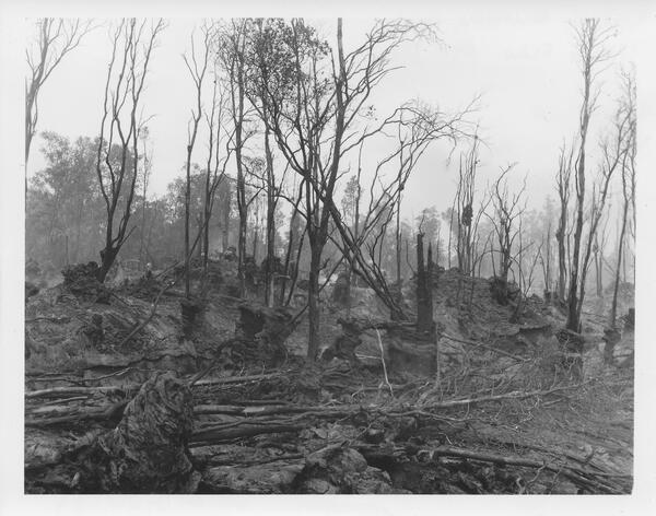
Forest of lava trees, Kilauea Volcano, 1983
Forest of lava trees resulting from eruption of a 1-km-line of vents east of Pu'u Kahaulea on Hawai'i Island's Kilauea Volcano. The bulbous top of each lava tree marks the high stand of the lava flow as it spread through the trees.
Forest of lava trees resulting from eruption of a 1-km-line of vents east of Pu'u Kahaulea on Hawai'i Island's Kilauea Volcano. The bulbous top of each lava tree marks the high stand of the lava flow as it spread through the trees.

Lava fountains erupting from fissures, Kīlauea, Hawai‘i
Lava fountains erupting from fissures, Kīlauea, Hawai‘iLava fountains erupt from fissures during the first week of the Pu‘u ‘Ō‘ō eruption south of Pu‘u Kahaualea, approximately 2.4 km (1.5 miles) northeast of where subsequent eruptions built the Pu‘u ‘Ō‘ō cone. The early fissures cut through old forested lava flows in a remote section of Kīlauea's east rift zone.
Lava fountains erupting from fissures, Kīlauea, Hawai‘i
Lava fountains erupting from fissures, Kīlauea, Hawai‘iLava fountains erupt from fissures during the first week of the Pu‘u ‘Ō‘ō eruption south of Pu‘u Kahaualea, approximately 2.4 km (1.5 miles) northeast of where subsequent eruptions built the Pu‘u ‘Ō‘ō cone. The early fissures cut through old forested lava flows in a remote section of Kīlauea's east rift zone.

Volcano Craters
Left: Horseshoe-shaped crater of Mount St. Helens in 1980, formed by a landslide that removed the top of the volcano. The crater is about 2 km (1.2 mi) wide and the floor is about 600 m (1,970 ft) below the crater rim. Right: Halema‘uma‘u nestled in the summit crater of Kīlauea Volcano on August 1, the day before the last collapse event.
Left: Horseshoe-shaped crater of Mount St. Helens in 1980, formed by a landslide that removed the top of the volcano. The crater is about 2 km (1.2 mi) wide and the floor is about 600 m (1,970 ft) below the crater rim. Right: Halema‘uma‘u nestled in the summit crater of Kīlauea Volcano on August 1, the day before the last collapse event.
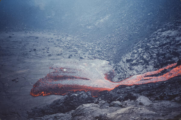
November 1979 Pauahi Eruption
The November 16, 1979, eruption near Pauahi Crater was a brief, one-day event on the upper East Rift Zone. It was preceded by two months of increased seismic activity, summit inflation, and lava erupting from fissures west of, within, and east of the crater.
The November 16, 1979, eruption near Pauahi Crater was a brief, one-day event on the upper East Rift Zone. It was preceded by two months of increased seismic activity, summit inflation, and lava erupting from fissures west of, within, and east of the crater.

Submerged coconut grove at Halapē after 1975 quake, Kīlauea
Submerged coconut grove at Halapē after 1975 quake, KīlaueaA M 7.7 earthquake on November 29, 1975, was located beneath the south flank of Kīlauea.
Submerged coconut grove at Halapē after 1975 quake, Kīlauea
Submerged coconut grove at Halapē after 1975 quake, KīlaueaA M 7.7 earthquake on November 29, 1975, was located beneath the south flank of Kīlauea.
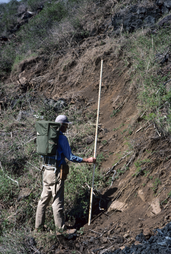
1975 earthquake scarp near Poliokeawe Pali
A USGS Hawaiian Volcano Observatory geologist measures a scarp that formed on the south flank of Kīlauea during the magnitude-7.2 earthquake in 1975. In this area, near Poliokeawe Pali in Hawaiʻi Volcanoes National Park, the scarp is about 1.5 meters (5 feet) high. USGS photo by P. Lipman.
A USGS Hawaiian Volcano Observatory geologist measures a scarp that formed on the south flank of Kīlauea during the magnitude-7.2 earthquake in 1975. In this area, near Poliokeawe Pali in Hawaiʻi Volcanoes National Park, the scarp is about 1.5 meters (5 feet) high. USGS photo by P. Lipman.

Earthquake-damaged road, Hawai‘i Volcanoes National Park, Kīlauea
Earthquake-damaged road, Hawai‘i Volcanoes National Park, KīlaueaGround cracks along Crater Rim Drive in Hawai‘i Volcanoes National Park caused by the M 7.7 earthquake on November 25, 1975. The cracks resulted from slumping of the ground toward the rim of Kīlauea Crater, the edge of which is left of the guardrails.
Earthquake-damaged road, Hawai‘i Volcanoes National Park, Kīlauea
Earthquake-damaged road, Hawai‘i Volcanoes National Park, KīlaueaGround cracks along Crater Rim Drive in Hawai‘i Volcanoes National Park caused by the M 7.7 earthquake on November 25, 1975. The cracks resulted from slumping of the ground toward the rim of Kīlauea Crater, the edge of which is left of the guardrails.

December 31, 1974, eruption from the Southwest Rift Zone of Kīlauea
December 31, 1974, eruption from the Southwest Rift Zone of KīlaueaPhotograph of the December 31, 1974, eruption from the Southwest Rift Zone of Kīlauea. This early morning photo shows the lava fountains feeding the eruption and throwing lava bombs to 115–130 feet (35–40 meters) high. This eruption was very brief, lasting from 2:56 a.m. to around 8:50 a.m. USGS photo by Robin Holcomb.
December 31, 1974, eruption from the Southwest Rift Zone of Kīlauea
December 31, 1974, eruption from the Southwest Rift Zone of KīlaueaPhotograph of the December 31, 1974, eruption from the Southwest Rift Zone of Kīlauea. This early morning photo shows the lava fountains feeding the eruption and throwing lava bombs to 115–130 feet (35–40 meters) high. This eruption was very brief, lasting from 2:56 a.m. to around 8:50 a.m. USGS photo by Robin Holcomb.

Kīlauea's 1971 Southwest Rift Zone Eruption: A First in 52 Years
Kīlauea's 1971 Southwest Rift Zone Eruption: A First in 52 YearsAs erupting fissures migrated down Kīlauea's southwest rift zone in September 1971 for the first time in 52 years, many spectators hiked into the Ka‘ū Desert for a closer view of the rare event. Hawai‘i Volcanoes National Park rangers patrolled the area on horseback to keep people a safe distance from the lava fountains. Photo courtesy of NPS.
Kīlauea's 1971 Southwest Rift Zone Eruption: A First in 52 Years
Kīlauea's 1971 Southwest Rift Zone Eruption: A First in 52 YearsAs erupting fissures migrated down Kīlauea's southwest rift zone in September 1971 for the first time in 52 years, many spectators hiked into the Ka‘ū Desert for a closer view of the rare event. Hawai‘i Volcanoes National Park rangers patrolled the area on horseback to keep people a safe distance from the lava fountains. Photo courtesy of NPS.

South flank of Kīlauea consists of several large scarps formed by r...
South flank of Kīlauea consists of several large scarps formed by r...Seaward sliding of Kīlauea's south flank over many thousands of years has resulted in large ground displacements along shallow faults that break the surface, as shown by the cliffs ("pali" in Hawaiian) seen here. Most of the movement along the faults occur during sudden slip that cause large earthquakes.
South flank of Kīlauea consists of several large scarps formed by r...
South flank of Kīlauea consists of several large scarps formed by r...Seaward sliding of Kīlauea's south flank over many thousands of years has resulted in large ground displacements along shallow faults that break the surface, as shown by the cliffs ("pali" in Hawaiian) seen here. Most of the movement along the faults occur during sudden slip that cause large earthquakes.

VO scientist measures Mauna Ulu lava fountain
HVO scientist measures the episode 12 lava fountain height at Mauna Ulu from Puʻu Huluhulu on Dec 30, 1969. The Mauna Ulu eruption marks its 51st anniversary on May 24, 1969.
HVO scientist measures the episode 12 lava fountain height at Mauna Ulu from Puʻu Huluhulu on Dec 30, 1969. The Mauna Ulu eruption marks its 51st anniversary on May 24, 1969.

lava fountain
This lava fountain, which erupted on September 6, 1969, during the Mauna Ulu eruption, was about 540 m (1770 ft) tall. The tephra cone, eventually named Mauna Ulu, can be seen in the fallout area (right of the fountains. in middle of image). It is now a 121 m (397 ft) tall lava shield in Hawai‘i Volcanoes National Park.
This lava fountain, which erupted on September 6, 1969, during the Mauna Ulu eruption, was about 540 m (1770 ft) tall. The tephra cone, eventually named Mauna Ulu, can be seen in the fallout area (right of the fountains. in middle of image). It is now a 121 m (397 ft) tall lava shield in Hawai‘i Volcanoes National Park.
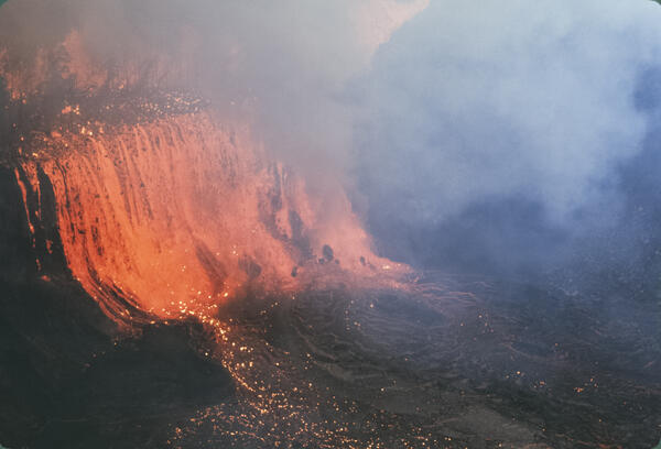
1969 Rift Eruption near Nāpau Crater
The February 1969 rift eruption near Nāpau Crater was a brief but dynamic precursor to the long-lived Maunaulu eruption that began in May of that year. This week-long event featured lava fountaining from multiple fissures along a 2.5-mile stretch of Kīlauea’s upper East Rift Zone.
The February 1969 rift eruption near Nāpau Crater was a brief but dynamic precursor to the long-lived Maunaulu eruption that began in May of that year. This week-long event featured lava fountaining from multiple fissures along a 2.5-mile stretch of Kīlauea’s upper East Rift Zone.
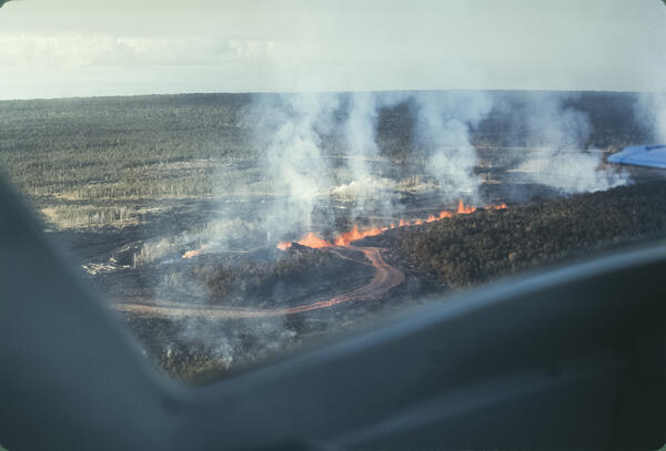
October 1968 eruptive fissures in the middle East Rift Zone of Kīlauea
October 1968 eruptive fissures in the middle East Rift Zone of KīlaueaAn aerial photo of a segment of the 1968 eruptive fissures in the middle East Rift Zone of Kīlauea. A line of lava fountains is feeding a small lava channel on October 8, 1968, during the second day of this eruption. USGS photo taken by D. Swanson.
October 1968 eruptive fissures in the middle East Rift Zone of Kīlauea
October 1968 eruptive fissures in the middle East Rift Zone of KīlaueaAn aerial photo of a segment of the 1968 eruptive fissures in the middle East Rift Zone of Kīlauea. A line of lava fountains is feeding a small lava channel on October 8, 1968, during the second day of this eruption. USGS photo taken by D. Swanson.

Halema‘uma‘u crater erupting in 1967
A telephoto image of vents erupting on the floor of Halema‘uma‘u crater, at the summit of Kīlauea, in 1967. NPS photo by C. Stoughton.
A telephoto image of vents erupting on the floor of Halema‘uma‘u crater, at the summit of Kīlauea, in 1967. NPS photo by C. Stoughton.

Halema‘uma‘u crater erupting in 1967
An aerial overview of Halema‘uma‘u crater erupting in early December 1967. USGS image.
An aerial overview of Halema‘uma‘u crater erupting in early December 1967. USGS image.

1967 felt earthquake report for M3.9 earthquake at Kīlauea
1967 felt earthquake report for M3.9 earthquake at KīlaueaEarthquake report card from 1967 containing detailed information of personally observed effects from a M3.9 earthquake at the summit of Kīlauea. HVO staff distributed the report cards to local citizens between 1930 and 1989.
1967 felt earthquake report for M3.9 earthquake at Kīlauea
1967 felt earthquake report for M3.9 earthquake at KīlaueaEarthquake report card from 1967 containing detailed information of personally observed effects from a M3.9 earthquake at the summit of Kīlauea. HVO staff distributed the report cards to local citizens between 1930 and 1989.
1961 Fissure Eruption near Nāpau Crater
The 1961 fissure eruption near Nāpau Crater was a short-lived but notable event on Kīlauea’s East Rift Zone, occurring in late September. Over two days, lava erupted from vents along a 13-mile stretch, producing 13 small flows and lava fountains that reached heights of up to 400 feet, with the largest flows occurring near Pāhoa.
The 1961 fissure eruption near Nāpau Crater was a short-lived but notable event on Kīlauea’s East Rift Zone, occurring in late September. Over two days, lava erupted from vents along a 13-mile stretch, producing 13 small flows and lava fountains that reached heights of up to 400 feet, with the largest flows occurring near Pāhoa.