



The July 1961 eruption at Halemaʻumaʻu was the third summit eruption of that year, continuing the pattern of vigorous volcanic activity at Kīlauea. This event featured sustained lava fountaining and further infilling of the crater, building upon the changes initiated by the February and March eruptions.
Images
Kīlauea images of eruptive activity, field work, and more.
Filter Total Items: 3194
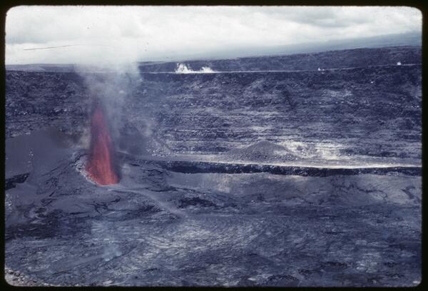
July 1961 Summit Eruption
The July 1961 eruption at Halemaʻumaʻu was the third summit eruption of that year, continuing the pattern of vigorous volcanic activity at Kīlauea. This event featured sustained lava fountaining and further infilling of the crater, building upon the changes initiated by the February and March eruptions.

Displacement of Kapoho fault scarp, Kīlauea, Hawai‘i, caused by mag...
Displacement of Kapoho fault scarp, Kīlauea, Hawai‘i, caused by mag...View westward along the Kapoho fault scarp in the village of Kapoho following a swarm of earthquakes in the area. The ground cracking was caused by subsidence of a graben (down-dropped block) that spanned the community.
Displacement of Kapoho fault scarp, Kīlauea, Hawai‘i, caused by mag...
Displacement of Kapoho fault scarp, Kīlauea, Hawai‘i, caused by mag...View westward along the Kapoho fault scarp in the village of Kapoho following a swarm of earthquakes in the area. The ground cracking was caused by subsidence of a graben (down-dropped block) that spanned the community.

Lava fountain in early morning, Kīlauea Iki, Kīlauea, Hawai‘i
Lava fountain in early morning, Kīlauea Iki, Kīlauea, Hawai‘iGreat quantities of lava pour from the base of a 480-m-tall (1,575 ft) fountain about 65 minutes after the start of episode 16. Lava discharge at this time was about 1.3 million cubic meters per hour (1.7 million cubic yards), which sent lava over the entire lake by 4:05 a.m.
Lava fountain in early morning, Kīlauea Iki, Kīlauea, Hawai‘i
Lava fountain in early morning, Kīlauea Iki, Kīlauea, Hawai‘iGreat quantities of lava pour from the base of a 480-m-tall (1,575 ft) fountain about 65 minutes after the start of episode 16. Lava discharge at this time was about 1.3 million cubic meters per hour (1.7 million cubic yards), which sent lava over the entire lake by 4:05 a.m.

Measuring Kīlauea magnetic field strength
Hawaiian Volcano Observatory Scientists at the rim of Kīlauea volcano measuring variations in magnetic field strength in 1950. Photo by Ray E. Wilcox.
Hawaiian Volcano Observatory Scientists at the rim of Kīlauea volcano measuring variations in magnetic field strength in 1950. Photo by Ray E. Wilcox.

1924 explosive eruptions from Halemaʻumaʻu
Photographs of the 1924 explosive eruptions from Halemaʻumaʻu. The photograph on the left is from the Uēkahuna bluff on May 18, 1924, by Kenichi Maehara. The photograph on the right is from near the present-day site of Volcano House on May 22, 1924, by Tai Sing Loo.
Photographs of the 1924 explosive eruptions from Halemaʻumaʻu. The photograph on the left is from the Uēkahuna bluff on May 18, 1924, by Kenichi Maehara. The photograph on the right is from near the present-day site of Volcano House on May 22, 1924, by Tai Sing Loo.

Ruy H. Finch (1890-1957)
The founder of the Lassen Volcano Observatory (1926-1935) and second Director of the Hawaiian Volcano Observatory (1940-1951), Ruy Herbert Finch conducted research in both Hawaii and throughout the Western United States.
The founder of the Lassen Volcano Observatory (1926-1935) and second Director of the Hawaiian Volcano Observatory (1940-1951), Ruy Herbert Finch conducted research in both Hawaii and throughout the Western United States.

Ejected tephra from Halemaumau at Kīlauea, May 31, 1925
Ejected tephra from Halemaumau at Kīlauea, May 31, 1925This scene west of Halemaumau looks toward the rim of the caldera, southwest of Uēkahuna Bluff. New ballistic blocks and ash from the 1924 eruption coat the floor of the caldera.
Ejected tephra from Halemaumau at Kīlauea, May 31, 1925
Ejected tephra from Halemaumau at Kīlauea, May 31, 1925This scene west of Halemaumau looks toward the rim of the caldera, southwest of Uēkahuna Bluff. New ballistic blocks and ash from the 1924 eruption coat the floor of the caldera.

Airplane landing field at Kīlauea strewn with blocks from several e...
Airplane landing field at Kīlauea strewn with blocks from several e...Prior to the eruption of 1924, this area was swept clean and used as a landing field for airplanes. This view looking toward the north rim of Halemaumau shows the air field littered with ballistic blocks from explosions in the 1924 eruption.
Airplane landing field at Kīlauea strewn with blocks from several e...
Airplane landing field at Kīlauea strewn with blocks from several e...Prior to the eruption of 1924, this area was swept clean and used as a landing field for airplanes. This view looking toward the north rim of Halemaumau shows the air field littered with ballistic blocks from explosions in the 1924 eruption.

Explosion from Halemaumau at Kīlauea May 18, 1924.
Explosion from Halemaumau at Kīlauea May 18, 1924.This was probably the strongest explosion of the eruption. Rocks and debris fell among spectators southeast of Halemaumau, causing one fatality. A torrential downpour and an electrical storm followed.
Explosion from Halemaumau at Kīlauea May 18, 1924.
Explosion from Halemaumau at Kīlauea May 18, 1924.This was probably the strongest explosion of the eruption. Rocks and debris fell among spectators southeast of Halemaumau, causing one fatality. A torrential downpour and an electrical storm followed.

Spectators flee explosion from Halemaumau at Kīlauea, May 18, 1925
Spectators flee explosion from Halemaumau at Kīlauea, May 18, 1925Acting HVO director Ruy Finch snapped this photograph of spectators running away as large blocks were tossed about 600 meters (2000 feet) onto an airplane landing field. Lorrin A.
Spectators flee explosion from Halemaumau at Kīlauea, May 18, 1925
Spectators flee explosion from Halemaumau at Kīlauea, May 18, 1925Acting HVO director Ruy Finch snapped this photograph of spectators running away as large blocks were tossed about 600 meters (2000 feet) onto an airplane landing field. Lorrin A.

Park superintendent Thomas Boles after a narrow escape at Kīlauea, ...
Park superintendent Thomas Boles after a narrow escape at Kīlauea, ...Boles poses on the grounds of the Volcano House hotel with the Halemaumau eruption plume in the background. He fell cutting his hands and a knee while fleeing an explosion the day before. After his close call the superintendent barred all public access within two miles of Halemaumau.
Park superintendent Thomas Boles after a narrow escape at Kīlauea, ...
Park superintendent Thomas Boles after a narrow escape at Kīlauea, ...Boles poses on the grounds of the Volcano House hotel with the Halemaumau eruption plume in the background. He fell cutting his hands and a knee while fleeing an explosion the day before. After his close call the superintendent barred all public access within two miles of Halemaumau.

Explosion at Halema‘uma‘u as seen from Uēkahuna Bluff, at Kīlauea, ...
Explosion at Halema‘uma‘u as seen from Uēkahuna Bluff, at Kīlauea, ...Eight persons, including newspaper and movie men observing the scene at Halema‘uma‘u, were caught in a rain of hot rocks from this explosion. The rocks emitted hissing sounds as hot gas, mainly steam, escaped from them. Park superintendent Thomas Boles was knocked down twice by this bombardment.
Explosion at Halema‘uma‘u as seen from Uēkahuna Bluff, at Kīlauea, ...
Explosion at Halema‘uma‘u as seen from Uēkahuna Bluff, at Kīlauea, ...Eight persons, including newspaper and movie men observing the scene at Halema‘uma‘u, were caught in a rain of hot rocks from this explosion. The rocks emitted hissing sounds as hot gas, mainly steam, escaped from them. Park superintendent Thomas Boles was knocked down twice by this bombardment.

Boulder ejected from Halemaumau, at Kīlauea, May 11, 1925
Boulder ejected from Halemaumau, at Kīlauea, May 11, 1925On May 11, Ruy Finch and W.O. Clark visited Halemaumau and found a rock fragment weighing about 180 kg (400 pounds) that had been thrown 60 meters (200 feet) from the rim of the crater.
Boulder ejected from Halemaumau, at Kīlauea, May 11, 1925
Boulder ejected from Halemaumau, at Kīlauea, May 11, 1925On May 11, Ruy Finch and W.O. Clark visited Halemaumau and found a rock fragment weighing about 180 kg (400 pounds) that had been thrown 60 meters (200 feet) from the rim of the crater.

First explosion clouds from Halemaumau, Kīlauea 1925
First explosion clouds from Halemaumau, Kīlauea 1925Later scientists at the Observatory listed May 10 as the first day of the eruptive series. Between this date and May 27, they carefully recorded all explosions, ballistic falls, electric storms, and muddy rains as well as earthquakes felt and recorded on seismographs.
First explosion clouds from Halemaumau, Kīlauea 1925
First explosion clouds from Halemaumau, Kīlauea 1925Later scientists at the Observatory listed May 10 as the first day of the eruptive series. Between this date and May 27, they carefully recorded all explosions, ballistic falls, electric storms, and muddy rains as well as earthquakes felt and recorded on seismographs.

Halemaʻumaʻu lava lake on December 11, 1919
Panorama photos taken of Halemaʻumaʻu lava lake on December 11, 1919, showing the outer ring-shaped lake, the ring-shaped island of tilted crusts along the inner edge, and the central lava lake at Kīlauea's summit. USGS photos by T.A. Jaggar.
Panorama photos taken of Halemaʻumaʻu lava lake on December 11, 1919, showing the outer ring-shaped lake, the ring-shaped island of tilted crusts along the inner edge, and the central lava lake at Kīlauea's summit. USGS photos by T.A. Jaggar.

View of the walls of Halemaʻumaʻu during the crater collapse of June 5, 1916, looking northeast from the south side of the crater
View of the walls of Halemaʻumaʻu during the crater collapse of June 5, 1916, looking northeast from the south side of the craterView of the walls of Halemaʻumaʻu during the crater collapse of June 5, 1916, looking northeast from the south side of the crater. The lava lake is visible at the lower left, and the outer crater walls are at the top. The crater rim is just out of frame to the top.
View of the walls of Halemaʻumaʻu during the crater collapse of June 5, 1916, looking northeast from the south side of the crater
View of the walls of Halemaʻumaʻu during the crater collapse of June 5, 1916, looking northeast from the south side of the craterView of the walls of Halemaʻumaʻu during the crater collapse of June 5, 1916, looking northeast from the south side of the crater. The lava lake is visible at the lower left, and the outer crater walls are at the top. The crater rim is just out of frame to the top.

Hawaiian Volcano Observatory “Technology Station”
The Hawaiian Volcano Observatory (HVO), founded in 1912 by Thomas A. Jaggar, was the first of five volcano observatories supported by USGS today. The “Technology Station” (circled) on the eastern rim of Halema‘uma‘u crater—at the summit of Kīlauea—was the first, though temporary, of several buildings that HVO has occupied since its founding.
The Hawaiian Volcano Observatory (HVO), founded in 1912 by Thomas A. Jaggar, was the first of five volcano observatories supported by USGS today. The “Technology Station” (circled) on the eastern rim of Halema‘uma‘u crater—at the summit of Kīlauea—was the first, though temporary, of several buildings that HVO has occupied since its founding.

Children pose with 8 ton ballistic block at Kīlauea, Hawai‘i.
Children pose with 8 ton ballistic block at Kīlauea, Hawai‘i.Some of the large ballistic blocks from the Kīlauea eruption of 1924 later became visitor attractions. Many of these blocks remain in place today as evidence of the forces unleashed at Kīlauea during the eruption of 1924.
Children pose with 8 ton ballistic block at Kīlauea, Hawai‘i.
Children pose with 8 ton ballistic block at Kīlauea, Hawai‘i.Some of the large ballistic blocks from the Kīlauea eruption of 1924 later became visitor attractions. Many of these blocks remain in place today as evidence of the forces unleashed at Kīlauea during the eruption of 1924.

Coconut grove and campground on the southern shoreline of Kīlauea a...
Coconut grove and campground on the southern shoreline of Kīlauea a...Coconut grove and campground on the southern shoreline of Kīlauea Volcano at Halapē before 1975 magnitude 7.7 earthquake. Halapē was a popular hiking destination in Hawai‘i Volcanoes National Park.
Coconut grove and campground on the southern shoreline of Kīlauea a...
Coconut grove and campground on the southern shoreline of Kīlauea a...Coconut grove and campground on the southern shoreline of Kīlauea Volcano at Halapē before 1975 magnitude 7.7 earthquake. Halapē was a popular hiking destination in Hawai‘i Volcanoes National Park.

Shaded relief map of Kīlauea's summit with caldera
Shaded relief map of Kīlauea's summit with calderaShaded relief map of Kīlauea Volcano's summit with caldera bounding faults delineated.
Shaded relief map of Kīlauea's summit with caldera
Shaded relief map of Kīlauea's summit with calderaShaded relief map of Kīlauea Volcano's summit with caldera bounding faults delineated.

1892 and 1894 cross-sections of Halemaʻumaʻu crater
1892 and 1894 cross-sections of Halemaʻumaʻu craterSurveyor Frank Dodge's 1894 cross-section of Halema‘uma‘u overlaid on his 1892 cross-section. The 1892 lava lake was measured at 73 m (240 ft) below the rim of Halema‘uma‘u pit and by early-1894, the lava lake had filled the pit and frequently overflowed onto the caldera floor.
1892 and 1894 cross-sections of Halemaʻumaʻu crater
1892 and 1894 cross-sections of Halemaʻumaʻu craterSurveyor Frank Dodge's 1894 cross-section of Halema‘uma‘u overlaid on his 1892 cross-section. The 1892 lava lake was measured at 73 m (240 ft) below the rim of Halema‘uma‘u pit and by early-1894, the lava lake had filled the pit and frequently overflowed onto the caldera floor.