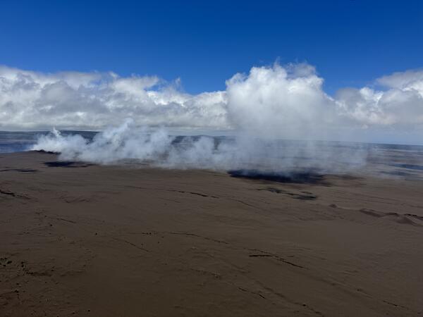
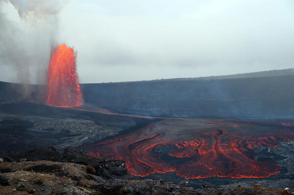
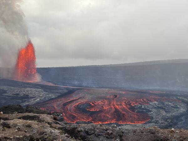
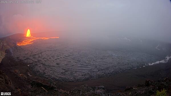
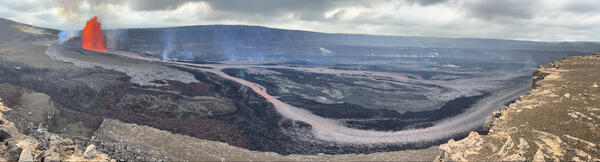
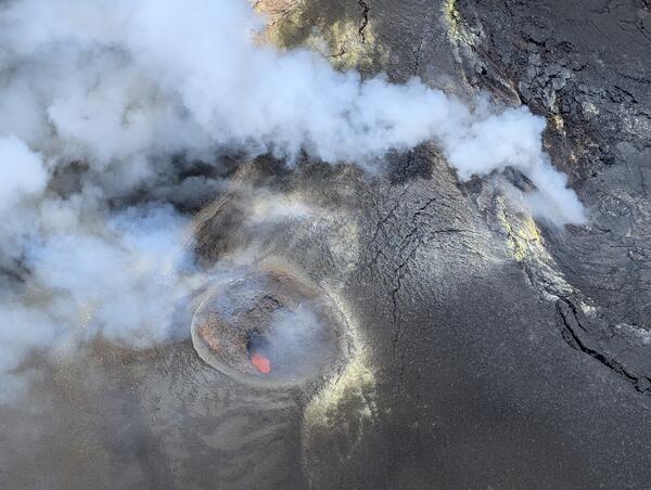
U.S. flag

An official website of the United States government

Images

Kīlauea images of eruptive activity, field work, and more.

Filter Total Items: 2928
color photo looking down at cooled black lava and pale gray steam.
September 24, 2025 — North and south vents at the summit of Kīlauea

USGS Hawaiian Volcano Observatory scientists took this oblique angle view of north (center) and south vents (to the right and closer to top of photo) during a Kīlauea summit monitoring overflight on September 24. The brown sand-like material that covers the right and top parts of the photo are tephra erupted during episode 33.

USGS Hawaiian Volcano Observatory scientists took this oblique angle view of north (center) and south vents (to the right and closer to top of photo) during a Kīlauea summit monitoring overflight on September 24. The brown sand-like material that covers the right and top parts of the photo are tephra erupted during episode 33.

color photo of the Kaluapele with the steaming vents in the distance.
September 24, 2025 — Overview of Kaluapele

The USGS Hawaiian Volcano Observatory's helicopter overflight on September 24 provided aerial views of Kaluapele (Kīlauea caldera) from the east looking west. The vents of the eruption that started on December 23, 2024 are degassing on the western side of Halema‘uma‘u crater. Mauna Loa can be seen in the background. USGS photo by N. Deligne.

The USGS Hawaiian Volcano Observatory's helicopter overflight on September 24 provided aerial views of Kaluapele (Kīlauea caldera) from the east looking west. The vents of the eruption that started on December 23, 2024 are degassing on the western side of Halema‘uma‘u crater. Mauna Loa can be seen in the background. USGS photo by N. Deligne.

color photo looking down at what look like two small holes in the rock that are the north and south vents.
September 24, 2025 — North and south vents at Kīlauea volcano

USGS Hawaiian Volcano Observatory scientists did not see any lava at the bottom of north (bottom right) or south (center) vents during a Kīlauea summit monitoring overflight on September 24. This photo shows the western wall of Halema‘uma‘u, and much of the slope is covered in brown tephra erupted during episode 33 on September 19. USGS photo by N.

USGS Hawaiian Volcano Observatory scientists did not see any lava at the bottom of north (bottom right) or south (center) vents during a Kīlauea summit monitoring overflight on September 24. This photo shows the western wall of Halema‘uma‘u, and much of the slope is covered in brown tephra erupted during episode 33 on September 19. USGS photo by N.

color photo looking toward an old eruption site from the 1980s with a clear hiking trail across it worn by visitors.
September 24, 2025 — Aerial view of Kīlauea Iki, Pu‘u Pua‘i, Pu‘u‘ō‘ō, and Kānenuiohamo, and Maunaulu

This aerial view of Kīlauea Iki (center crater with lava covering the floor) and Pu‘u Pua‘i (brown hill to its right) was taken during a USGS Hawaiian Volcano Observatory monitoring overflight of Kīlauea summit on September 24. On the horizon from left to right are, Pu‘u‘ō‘ō (center), Kānenuiohamo (right of center), and Maunaulu (right).

This aerial view of Kīlauea Iki (center crater with lava covering the floor) and Pu‘u Pua‘i (brown hill to its right) was taken during a USGS Hawaiian Volcano Observatory monitoring overflight of Kīlauea summit on September 24. On the horizon from left to right are, Pu‘u‘ō‘ō (center), Kānenuiohamo (right of center), and Maunaulu (right).

color photo of two geologist looking at the lava fountain in the background.
September 19, 2025 – Observing episode 33

HVO geologists collect video and make visual observations of the episode 33 lava fountain, at the summit of Kīlauea. USGS photo by M. Patrick.

HVO geologists collect video and make visual observations of the episode 33 lava fountain, at the summit of Kīlauea. USGS photo by M. Patrick.

color photo of two scientists walking away after observing the lava fountain in the distance.
September 19, 2025 – Lava fountain observed from the old Crater Rim Drive.

HVO geologists make an initial assessment of the episode 33 lava fountain from the collapsed end of Crater Rim Drive, at the summit of Kīlauea. This portion of Crater Rim Drive was destroyed during the 2018 summit collapse events, and is closed to the public. USGS photo by M. Patrick.

HVO geologists make an initial assessment of the episode 33 lava fountain from the collapsed end of Crater Rim Drive, at the summit of Kīlauea. This portion of Crater Rim Drive was destroyed during the 2018 summit collapse events, and is closed to the public. USGS photo by M. Patrick.

color photo of a man's hand holding a large, black lava bomb about the size of a basketball.
September 19, 2025 – A lava bomb from the north vent

A lava bomb from the north vent above the crater rim that was found not long after it landed and cooled. As the molten bombs fly through the air, they cool and form a glassy crust with the interior full of vesicles. Most shatter into many pieces upon impact with the ground, but on rare occasions some stay mostly intact.

A lava bomb from the north vent above the crater rim that was found not long after it landed and cooled. As the molten bombs fly through the air, they cool and form a glassy crust with the interior full of vesicles. Most shatter into many pieces upon impact with the ground, but on rare occasions some stay mostly intact.

color photo of lava fountain visible beyond the end of a broken road.
September 19, 2025 – Lava fountain from the old Crater Rim Drive.

The episode 33 lava fountain from the north vent, at the summit of Kīlauea, is seen beyond the collapsed end of Crater Rim Drive. This portion of Crater Rim Drive was destroyed during the 2018 summit collapse events, and is closed to the public. USGS photo by M. Patrick.

The episode 33 lava fountain from the north vent, at the summit of Kīlauea, is seen beyond the collapsed end of Crater Rim Drive. This portion of Crater Rim Drive was destroyed during the 2018 summit collapse events, and is closed to the public. USGS photo by M. Patrick.

Color photo of cooled, black lava that overflowed from the north vent.
September 17, 2025 – Remains of overflow from north vent

At 8:38 a.m. HST on September 17, the Halema‘uma‘u north vent overflowed for the first time in advance of Kīlauea summit eruptive episode 33.

Color map showing area covered by lava flows in recent volcanic eruption
September 12, 2025—Kīlauea summit eruption reference map

This reference map depicts the Kīlauea summit eruption within Halema‘uma‘u crater that began on December 23, 2024. As of this posting on September 12, 2025, the eruption has had thirty-two episodes, with the most recent occurring on September 2.

This reference map depicts the Kīlauea summit eruption within Halema‘uma‘u crater that began on December 23, 2024. As of this posting on September 12, 2025, the eruption has had thirty-two episodes, with the most recent occurring on September 2.

Color photograph of volcanic landscape with car driving in the distance
September 3, 2025 — Driving on the tephra deposit in Kīlauea summit region

This view is taken from the flank of the new tephra mound at Kīlauea summit, over Crater Rim Drive (closed to the public) in Hawai‘i Volcanoes National Park. The tire tracks of the vehicle mark the path of Crater Rim Drive.

This view is taken from the flank of the new tephra mound at Kīlauea summit, over Crater Rim Drive (closed to the public) in Hawai‘i Volcanoes National Park. The tire tracks of the vehicle mark the path of Crater Rim Drive.

Color photograph of volcanic terrain with bucket in foreground and degassing in background
September 3, 2025 — Kīlauea summit tephra collection bucket

Tephra is the material erupted that travels through the air before falling on the ground. During the ongoing eruption of Kīlauea, tephra from each episode of lava fountaining tells us about the magma storage conditions leading to the eruption.

Tephra is the material erupted that travels through the air before falling on the ground. During the ongoing eruption of Kīlauea, tephra from each episode of lava fountaining tells us about the magma storage conditions leading to the eruption.

Color photograph of vehicle on volcanic terrain with tire tracks in the background
September 3, 2025 — The closed portion of Crater Rim Drive Road at Kīlauea summit

The tire tracks in this photo trace the path of Crater Rim Drive (closed to the public) in Hawai‘i Volcanoes National Park. This part of the road is covered by more than a meter (yard) of tephra erupted since December 23, 2024. Just south of this photo, a large mound of tephra accumulated during the ongoing eruption has buried the road over 20 meters (yards) deep.

The tire tracks in this photo trace the path of Crater Rim Drive (closed to the public) in Hawai‘i Volcanoes National Park. This part of the road is covered by more than a meter (yard) of tephra erupted since December 23, 2024. Just south of this photo, a large mound of tephra accumulated during the ongoing eruption has buried the road over 20 meters (yards) deep.

Color photograph of bucket next to mound of volcanic material with person walking in the distance
September 3, 2025 — Tephra mound at Kīlauea summit

A USGS Hawaiian Volcano Observatory geologist descends from the new tephra mound at Kīlauea summit that has been deposited over part of Crater Rim Drive (closed to the public) in Hawai‘i Volcanoes National Park. The short wooden post in the bottom left is the top of a sign post for the road. A tephra collection bucket is situated here for tephra sampling.

A USGS Hawaiian Volcano Observatory geologist descends from the new tephra mound at Kīlauea summit that has been deposited over part of Crater Rim Drive (closed to the public) in Hawai‘i Volcanoes National Park. The short wooden post in the bottom left is the top of a sign post for the road. A tephra collection bucket is situated here for tephra sampling.

Color photograph of scientists monitoring eruption
September 2, 2025 — Observing Kīlauea summit eruption episode 32

From the north rim of Halemaʻumaʻu crater, USGS Hawaiian Volcano Observatory scientists document eruptive activity during episode 32 of the ongoing Kīlauea summit eruption. USGS photo by K. Mulliken.

From the north rim of Halemaʻumaʻu crater, USGS Hawaiian Volcano Observatory scientists document eruptive activity during episode 32 of the ongoing Kīlauea summit eruption. USGS photo by K. Mulliken.

Color photograph of lava fountain
S2cam view of Kīlauea summit eruption episode 32

This image was taken by the S2cam during episode 32 of the ongoing Kīlauea summit eruption, on September 2, 2025. The S2cam is a temporary webcamera positioned on the south rim of Kaluapele (Kīlauae summit caldera) and the view is to the west. USGS webcam image. 

This image was taken by the S2cam during episode 32 of the ongoing Kīlauea summit eruption, on September 2, 2025. The S2cam is a temporary webcamera positioned on the south rim of Kaluapele (Kīlauae summit caldera) and the view is to the west. USGS webcam image. 

Color photograph of lava fountain
S2cam image of eruption at Kīlauea summit

This image was taken by the S2cam during the ongoing Kīlauea summit eruption, and it has been cropped from the original version. The S2cam is a temporary webcamera positioned on the south rim of Kaluapele (Kīlauae summit caldera) and the view is to the west. USGS webcam image.  USGS photo. 

This image was taken by the S2cam during the ongoing Kīlauea summit eruption, and it has been cropped from the original version. The S2cam is a temporary webcamera positioned on the south rim of Kaluapele (Kīlauae summit caldera) and the view is to the west. USGS webcam image.  USGS photo. 

Color photograph of lava fountaining
September 2, 2025 — Kīlauea summit eruption episode 32

From the Kīlauea Overlook within Hawaiʻi Volcanoes National Park, USGS Hawaiian Volcano Observatory scientists documented episode 32 of the Kīlauea summit eruption that began on December 23, 2025.

From the Kīlauea Overlook within Hawaiʻi Volcanoes National Park, USGS Hawaiian Volcano Observatory scientists documented episode 32 of the Kīlauea summit eruption that began on December 23, 2025.

Color photograph of eruption within crater
September 2, 2025 — Kīlauea summit aerial overview during episode 32

Aerial view of the episode 32 lava fountain within Halema‘uma‘u during a USGS Hawaiian Volcano Observatory monitoring helicopter overflight at approximately 1:00 pm on September 2, 2025. Three vents were erupting from the western side of Halemaʻumaʻu, and feeding lava flows into the western side of the crater.

Aerial view of the episode 32 lava fountain within Halema‘uma‘u during a USGS Hawaiian Volcano Observatory monitoring helicopter overflight at approximately 1:00 pm on September 2, 2025. Three vents were erupting from the western side of Halemaʻumaʻu, and feeding lava flows into the western side of the crater.

Color photograph of eruption plume
September 2, 2025 — Aerial photo of episode 32 lava fountain, Kīlauea summit

USGS Hawaiian Volcano Observatory scientists conducted an overflight of Kīlauea summit to conduct an aerial photo survey and collect lava samples of the current episode. This photo shows the helicopter passing in front of the outgassing plume on its way into the caldera. USGS photo by M. Patrick.

USGS Hawaiian Volcano Observatory scientists conducted an overflight of Kīlauea summit to conduct an aerial photo survey and collect lava samples of the current episode. This photo shows the helicopter passing in front of the outgassing plume on its way into the caldera. USGS photo by M. Patrick.

Color photograph of lava channel flowing during eruption
September 2, 2025 —Lava flows during Kīlauea summit eruption episode 32

Lava fountaining from the north vent during episode 32 of Kīlauea's summit eruption fed a wide channel on Halemaʻumaʻu crater floor. USGS photo by N. Kohagura.

Was this page helpful?