



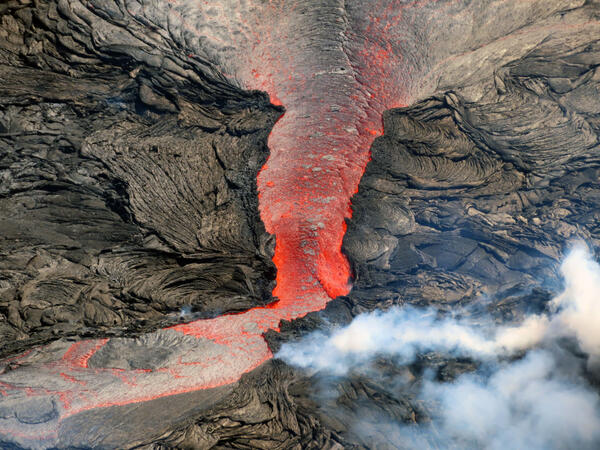
This telephoto view, taken during a eruption monitoring overflight of Kīlauea summit on March 2, 2022, shows the west vent area within Halema‘uma‘u crater. Lava erupts from multiple locations near where the west vent cone, which has broken down over the past several weeks, was located.
Images
Kīlauea images of eruptive activity, field work, and more.
Filter Total Items: 3057

March 2, 2022 — Kīlauea summit eruption resumes
This telephoto view, taken during a eruption monitoring overflight of Kīlauea summit on March 2, 2022, shows the west vent area within Halema‘uma‘u crater. Lava erupts from multiple locations near where the west vent cone, which has broken down over the past several weeks, was located.

March 2, 2022—Kīlauea summit thermal map
A helicopter overflight on March 2, 2022, allowed for aerial visual and thermal imagery to be collected of Halema‘uma‘u crater at the summit of Kīlauea. The active lake surface is limited to the western portion of the crater.
A helicopter overflight on March 2, 2022, allowed for aerial visual and thermal imagery to be collected of Halema‘uma‘u crater at the summit of Kīlauea. The active lake surface is limited to the western portion of the crater.

March 2, 2022 — Kīlauea summit
At approximately 8:15 a.m. on March 2, 2022, HVO geologists conducted an overflight of Kīlauea's summit. The eruption, which resumed several hours earlier, at approximately 1 a.m., continues within Halema‘uma‘u crater. In this photo, active lava is visible near the west vent, near the center of the image, and Mauna Loa looms in the background. USGS image by F.
At approximately 8:15 a.m. on March 2, 2022, HVO geologists conducted an overflight of Kīlauea's summit. The eruption, which resumed several hours earlier, at approximately 1 a.m., continues within Halema‘uma‘u crater. In this photo, active lava is visible near the west vent, near the center of the image, and Mauna Loa looms in the background. USGS image by F.

Summit tiltmeter data (green) shown against lava lake level (blue)
Summit tiltmeter data (green) shown against lava lake level (blue)Summit tiltmeter data (green) shown against lava lake level (blue). The top panel is for the time period 12/1/2017–1/30/2018 and is representative of the “old” lava lake. For this panel, lake level was retrieved from thermal camera images, hence it is given in units of “pixels.” The bottom panel is from 1/15/2022–2/15/2022; in this case, the lake l
Summit tiltmeter data (green) shown against lava lake level (blue)
Summit tiltmeter data (green) shown against lava lake level (blue)Summit tiltmeter data (green) shown against lava lake level (blue). The top panel is for the time period 12/1/2017–1/30/2018 and is representative of the “old” lava lake. For this panel, lake level was retrieved from thermal camera images, hence it is given in units of “pixels.” The bottom panel is from 1/15/2022–2/15/2022; in this case, the lake l

March 2, 2022 — Kīlauea west vent area
This aerial photo, taken south of Halema‘uma‘u crater, shows the active part of the eruption at Kīlauea summit during a routine Hawaiian Volcano Observatory monitoring overflight on March 2, 2022.
This aerial photo, taken south of Halema‘uma‘u crater, shows the active part of the eruption at Kīlauea summit during a routine Hawaiian Volcano Observatory monitoring overflight on March 2, 2022.

March 2, 2022 — Kīlauea lava lake distal margin activity
March 2, 2022 — Kīlauea lava lake distal margin activityTelephoto view of the distal (east) margin of the active lava lake within Halema‘uma‘u crater at the summit of Kīlauea. Minor spattering is visible along the margin, as well as a zone of crustal foundering (a process in which more cool and dense crust at the surface sinks into the molten material below). USGS image by K. Mulliken.
March 2, 2022 — Kīlauea lava lake distal margin activity
March 2, 2022 — Kīlauea lava lake distal margin activityTelephoto view of the distal (east) margin of the active lava lake within Halema‘uma‘u crater at the summit of Kīlauea. Minor spattering is visible along the margin, as well as a zone of crustal foundering (a process in which more cool and dense crust at the surface sinks into the molten material below). USGS image by K. Mulliken.

March 2, 2022 — Keanakāko‘i crater
Aerial view showing Keanakāko‘i crater, located on the south side of Kīlauea summit caldera. Crater Rim Drive, which remains closed to vehicles, is visible cross-cutting the image. Hawai‘i Volcanoes National Park has opened an eruption viewing area to the north of Keanakāko‘i crater, which is is visible in approximately the bottom center portion of the image.
Aerial view showing Keanakāko‘i crater, located on the south side of Kīlauea summit caldera. Crater Rim Drive, which remains closed to vehicles, is visible cross-cutting the image. Hawai‘i Volcanoes National Park has opened an eruption viewing area to the north of Keanakāko‘i crater, which is is visible in approximately the bottom center portion of the image.

March 2, 2022 — Kīlauea steam vents area
Hawaiian Volcano Observatory geologists captured this view of Wahinekapu (Steaming Bluff) and the Steam Vents area within Hawai‘i Volcanoes National Park during a routine morning overflight on March 2, 2022. Cracks in this area allow heated groundwater, which reaches up to 63 degrees Celsius (145 degrees Fahrenheit), to escape from underground as steam.
Hawaiian Volcano Observatory geologists captured this view of Wahinekapu (Steaming Bluff) and the Steam Vents area within Hawai‘i Volcanoes National Park during a routine morning overflight on March 2, 2022. Cracks in this area allow heated groundwater, which reaches up to 63 degrees Celsius (145 degrees Fahrenheit), to escape from underground as steam.

March 2, 2022 — Kīlauea summit Sulphur Banks area
Aerial image taken at approximately 8:30 a.m. during a USGS Hawaiian Volcano Observatory overflight on March 2, 2022. In the foreground, the Ha‘akulamanu trail in Hawai‘i Volcanoes National Park passes through the Sulphur Banks area, while the plume from the ongoing eruption within Halema‘uma‘u crater rises from Kīlauea caldera in the background. USGS photo by K.
Aerial image taken at approximately 8:30 a.m. during a USGS Hawaiian Volcano Observatory overflight on March 2, 2022. In the foreground, the Ha‘akulamanu trail in Hawai‘i Volcanoes National Park passes through the Sulphur Banks area, while the plume from the ongoing eruption within Halema‘uma‘u crater rises from Kīlauea caldera in the background. USGS photo by K.

March 2, 2022—Kīlauea summit thermal map
A helicopter overflight on March 2, 2022, allowed for aerial visual and thermal imagery to be collected of Halema‘uma‘u crater at the summit of Kīlauea. The active lake surface is limited to the western portion of the crater.
A helicopter overflight on March 2, 2022, allowed for aerial visual and thermal imagery to be collected of Halema‘uma‘u crater at the summit of Kīlauea. The active lake surface is limited to the western portion of the crater.

Weak lava flow in Halema‘uma‘u on February 18, 2022
Weak lava flow in Halema‘uma‘u on February 18, 2022On Friday, February 18, Hawaiian Volcano Observatory scientists visited the Halema‘uma‘u crater rim to observe the ongoing Kīlauea summit eruption. At the time of their visit, the lava lake in the western portion of the crater had drained substantially in association with deflation of the summit region.
Weak lava flow in Halema‘uma‘u on February 18, 2022
Weak lava flow in Halema‘uma‘u on February 18, 2022On Friday, February 18, Hawaiian Volcano Observatory scientists visited the Halema‘uma‘u crater rim to observe the ongoing Kīlauea summit eruption. At the time of their visit, the lava lake in the western portion of the crater had drained substantially in association with deflation of the summit region.

2021 Geologic Map of the State of Hawai‘i - District of Puna
2021 Geologic Map of the State of Hawai‘i - District of PunaA portion of the updated 2021 Geologic Map of the State of Hawai‘i showing part of the District of Puna in the County of Hawaii, where recent lava flow units have been added to the map. In this figure, the new lava flow units have been colored differently than the published map to emphasize their location. USGS map.
2021 Geologic Map of the State of Hawai‘i - District of Puna
2021 Geologic Map of the State of Hawai‘i - District of PunaA portion of the updated 2021 Geologic Map of the State of Hawai‘i showing part of the District of Puna in the County of Hawaii, where recent lava flow units have been added to the map. In this figure, the new lava flow units have been colored differently than the published map to emphasize their location. USGS map.

February 10, 2022 - Kīlauea summit eruption F1cam thermal image
February 10, 2022 - Kīlauea summit eruption F1cam thermal imageThis image was captured by the F1cam, a thermal camera located on the west rim of the caldera and looking east, at 4:42 a.m. HST on February 10, 2022. It shows the eruption within Halema‘uma‘u crater, at the summit of Kīlauea. USGS image.
February 10, 2022 - Kīlauea summit eruption F1cam thermal image
February 10, 2022 - Kīlauea summit eruption F1cam thermal imageThis image was captured by the F1cam, a thermal camera located on the west rim of the caldera and looking east, at 4:42 a.m. HST on February 10, 2022. It shows the eruption within Halema‘uma‘u crater, at the summit of Kīlauea. USGS image.
Standing wave in the lava flows at the summit of Kīlauea
Standing wave in the lava flows at the summit of KīlaueaA 1-meter (3-foot)-high standing wave was present in the spillway that is feeding the active portion of Kīlauea's summit lava lake, as seen from the west side of Halema‘uma‘u crater (in the vicinity of the KWcam and looking to the east). USGS photo by L. Gallant
Standing wave in the lava flows at the summit of Kīlauea
Standing wave in the lava flows at the summit of KīlaueaA 1-meter (3-foot)-high standing wave was present in the spillway that is feeding the active portion of Kīlauea's summit lava lake, as seen from the west side of Halema‘uma‘u crater (in the vicinity of the KWcam and looking to the east). USGS photo by L. Gallant

February 7, 2022 — Kīlauea afternoon activity in Halema‘uma‘u
February 7, 2022 — Kīlauea afternoon activity in Halema‘uma‘uOn the afternoon of Monday, February 7, 2022, Kīlauea's summit lava lake activity was located on the west side of Halema‘uma‘u crater.
February 7, 2022 — Kīlauea afternoon activity in Halema‘uma‘u
February 7, 2022 — Kīlauea afternoon activity in Halema‘uma‘uOn the afternoon of Monday, February 7, 2022, Kīlauea's summit lava lake activity was located on the west side of Halema‘uma‘u crater.

February 4, 2022 — Kīlauea
During the afternoon of February 4, HVO geologists observed abundant spattering within the perched margin of the active part of the lava lake in the west portion of Halema‘uma‘u at the summit of Kīlauea volcano. Over the weekend, the eruption has continued, with slight fluctuations in lava output. USGS image by K. Mulliken.
During the afternoon of February 4, HVO geologists observed abundant spattering within the perched margin of the active part of the lava lake in the west portion of Halema‘uma‘u at the summit of Kīlauea volcano. Over the weekend, the eruption has continued, with slight fluctuations in lava output. USGS image by K. Mulliken.

February 4, 2022 — Kīlauea
Lava cascades from a pond north of the west vent in Halema‘uma‘u into the active lava lake in the western portion of the crater. On the afternoon of February 4, the pond was measured as about one meter (a few feet) higher than the larger lava lake at the summit of Kīlauea. USGS photo by K. Mulliken.
Lava cascades from a pond north of the west vent in Halema‘uma‘u into the active lava lake in the western portion of the crater. On the afternoon of February 4, the pond was measured as about one meter (a few feet) higher than the larger lava lake at the summit of Kīlauea. USGS photo by K. Mulliken.

February 4, 2022 — Kīlauea
The west vent in Halema‘uma‘u was glowing as Kīlauea's summit eruption continued through the afternoon of February 4, 2022. From the west rim of Kīlauea caldera, HVO geologists could hear gas-jetting noises from the west vent, as well as from the spatter features on the inactive lava lake surface in the eastern portion of Halema‘uma‘u. USGS photo by K. Mulliken.
The west vent in Halema‘uma‘u was glowing as Kīlauea's summit eruption continued through the afternoon of February 4, 2022. From the west rim of Kīlauea caldera, HVO geologists could hear gas-jetting noises from the west vent, as well as from the spatter features on the inactive lava lake surface in the eastern portion of Halema‘uma‘u. USGS photo by K. Mulliken.

February 4, 2022 — Kīlauea
The lava lake in Halema‘uma‘u crater at the summit of Kīlauea was visibly full beneath overcast skies during a Hawaiian Volcano Observatory eruption monitoring field shift on February 4, 2022. This photo was taken from west rim of the Kīlauea caldera, in the vicinity of the KWcam. USGS photo by K. Mulliken.
The lava lake in Halema‘uma‘u crater at the summit of Kīlauea was visibly full beneath overcast skies during a Hawaiian Volcano Observatory eruption monitoring field shift on February 4, 2022. This photo was taken from west rim of the Kīlauea caldera, in the vicinity of the KWcam. USGS photo by K. Mulliken.

Recent activity at Kīlauea summit - February 1, 2022
Recent activity at Kīlauea summit - February 1, 2022Recent activity at the lava lake in Halema‘uma‘u crater, at the summit of Kīlauea. Lava upwelling at the western vent flows into the lake, where bubbling is commonly present. USGS image by M. Patrick.
Recent activity at Kīlauea summit - February 1, 2022
Recent activity at Kīlauea summit - February 1, 2022Recent activity at the lava lake in Halema‘uma‘u crater, at the summit of Kīlauea. Lava upwelling at the western vent flows into the lake, where bubbling is commonly present. USGS image by M. Patrick.

View of the active lava lake within Halemaʻumaʻu
The western part of Kīlauea's current summit eruption, showing the active part of the lava lake in Halema‘uma‘u crater. This lava lake is being fed from a small pond to the north of the impressive west vent. This photo was taken around 9:30 a.m. on Tuesday, February 1, 2022, from the west rim of Halemaʻumaʻu. USGS photo by D. Downs.
The western part of Kīlauea's current summit eruption, showing the active part of the lava lake in Halema‘uma‘u crater. This lava lake is being fed from a small pond to the north of the impressive west vent. This photo was taken around 9:30 a.m. on Tuesday, February 1, 2022, from the west rim of Halemaʻumaʻu. USGS photo by D. Downs.